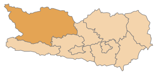
Hermagor District (Bezirk Hermagor)

- district of Austria
- Country:

- Licence Plate Code: HE
- Coordinates: 46° 39' 43" N, 13° 10' 59" E


- GPS tracks (wikiloc): [Link]
- AboveSeaLevel: 794 м m
- Area: 808.02 sq km
- Population: 19294
- Web site: http://www.bh-hermagor.at/
- Wikipedia en: wiki(en)
- Wikipedia: wiki(de)
- Wikidata storage: Wikidata: Q613991
- Wikipedia Commons Category: [Link]
- Freebase ID: [/m/06wk13]
- GeoNames ID: Alt: [2776496]
- VIAF ID: Alt: [125609257]
- GND ID: Alt: [4024502-0]
- archINFORM location ID: [14649]
- Quora topic ID: [Hermagor]
Includes regions:

Sankt Stefan im Gailtal
- municipality in Austria
- Country:
- Postal Code: 9623
- Local Dialing Code: 0 42 83
- Licence Plate Code: HE
- Coordinates: 46° 37' 0" N, 13° 31' 0" E
- GPS tracks (wikiloc): [Link]
- AboveSeaLevel: 726 м m
- Area: 66.33 sq km
- Population: 1593
- Web site: [Link]
Dellach
- municipality in Austria
- Country:
- Postal Code: 9635
- Local Dialing Code: 0 47 18
- Licence Plate Code: HE
- Coordinates: 46° 39' 41" N, 13° 4' 46" E
- GPS tracks (wikiloc): [Link]
- AboveSeaLevel: 672 м m
- Area: 36.17 sq km
- Population: 1231
- Web site: [Link]
Kirchbach
- municipality in Austria
- Country:
- Postal Code: 9632
- Local Dialing Code: 04284
- Licence Plate Code: HE
- Coordinates: 46° 38' 28" N, 13° 11' 0" E
- GPS tracks (wikiloc): [Link]
- AboveSeaLevel: 640 м m
- Area: 99.03 sq km
- Population: 2599
- Web site: [Link]

Kötschach-Mauthen
- municipality in Austria
- Country:
- Postal Code: 9640
- Local Dialing Code: 04715
- Licence Plate Code: HE
- Coordinates: 46° 40' 0" N, 13° 0' 0" E
- GPS tracks (wikiloc): [Link]
- AboveSeaLevel: 705 м m
- Area: 154.14 sq km
- Population: 3348
- Web site: [Link]


Hermagor-Pressegger See
- municipality in Austria
- Country:
- Postal Code: 9620
- Local Dialing Code: 04282
- Licence Plate Code: HE
- Coordinates: 46° 37' 38" N, 13° 22' 2" E
- GPS tracks (wikiloc): [Link]
- AboveSeaLevel: 602 м m
- Area: 204.84 sq km
- Population: 6824
- Web site: [Link]

Lesachtal
- municipality in Austria
- Country:
- Local Dialing Code: 04716
- Licence Plate Code: HE
- Coordinates: 46° 41' 38" N, 12° 48' 57" E
- GPS tracks (wikiloc): [Link]
- AboveSeaLevel: 1043 м m
- Area: 190.69 sq km
- Population: 1318
- Web site: [Link]

Gitschtal
- municipality in Austria
- Country:
- Postal Code: 9622
- Local Dialing Code: 0 42 86
- Licence Plate Code: HE
- Coordinates: 46° 40' 47" N, 13° 15' 38" E
- GPS tracks (wikiloc): [Link]
- AboveSeaLevel: 817 м m
- Area: 56.47 sq km
- Population: 1261
- Web site: [Link]
Shares border with regions:

Spittal an der Drau District
- administrative district in Carinthia, Austria
- Country:
- Licence Plate Code: SP
- Coordinates: 46° 49' 59" N, 13° 18' 22" E
- GPS tracks (wikiloc): [Link]
- AboveSeaLevel: 922 м m
- Area: 2764 sq km
- Population: 76248
- Web site: [Link]