Marzahn-Hellersdorf (Marzahn-Hellersdorf)
Includes regions:


Mahlsdorf
- locality of Berlin
- Country:

- Postal Code: 12623
- Coordinates: 52° 30' 22" N, 13° 36' 54" E


- GPS tracks (wikiloc): [Link]
- AboveSeaLevel: 53 м m
- Area: 12.94 sq km
- Population: 27504
Details...


Kaulsdorf
- locality of Berlin
- Country:
- Postal Code: 12619; 12621
- Coordinates: 52° 30' 29" N, 13° 34' 51" E
- GPS tracks (wikiloc): [Link]
- AboveSeaLevel: 55 м m
- Area: 8.81 sq km
- Population: 18656
Details...


Biesdorf
- locality of Berlin
- Country:
- Postal Code: 12683
- Coordinates: 52° 30' 33" N, 13° 33' 19" E
- GPS tracks (wikiloc): [Link]
- AboveSeaLevel: 44 м m
- Area: 12.44 sq km
- Population: 25622
Details...

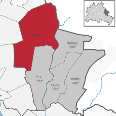
Marzahn
- locality of Berlin
- Country:
- Postal Code: 12689; 12687; 12685; 12681; 12679
- Coordinates: 52° 32' 45" N, 13° 33' 45" E
- GPS tracks (wikiloc): [Link]
- AboveSeaLevel: 62 м m
- Area: 19.54 sq km
- Population: 106640
Details...


Hellersdorf
- locality of Berlin
- Country:
- Postal Code: 12683; 12629; 12627; 12619
- Coordinates: 52° 32' 15" N, 13° 36' 15" E
- GPS tracks (wikiloc): [Link]
- AboveSeaLevel: 60 м m
- Area: 8.1 sq km
- Population: 78683
Details...
Shares border with regions:

Treptow-Köpenick
- borough of Berlin, Germany
- Country:
- Coordinates: 52° 27' 0" N, 13° 34' 0" E
- GPS tracks (wikiloc): [Link]
- Area: 168 sq km
- Web site: [Link]
Details...

Lichtenberg
- borough of Berlin, Germany
- Country:
- Coordinates: 52° 32' 0" N, 13° 30' 0" E
- GPS tracks (wikiloc): [Link]
- Area: 52.11 sq km
- Population: 275142
- Web site: [Link]
Details...