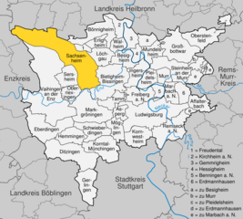
Sachsenheim (Sachsenheim)
- municipality in Germany
- Country:

- Postal Code: 74343
- Local Dialing Code: 07147; 07046
- Licence Plate Code: LB
- Coordinates: 48° 57' 36" N, 9° 3' 53" E


- GPS tracks (wikiloc): [Link]
- AboveSeaLevel: 246 м m
- Area: 57.92 sq km
- Population: 17861
- Web site: https://www.sachsenheim.de/
- Wikipedia en: wiki(en)
- Wikipedia: wiki(de)
- Wikidata storage: Wikidata: Q61920
- Wikipedia Commons Category: [Link]
Shares border with regions:


Markgröningen
- town in the district (Kreis) of Ludwigsburg, Baden-Württemberg, Germany
- Country:

- Postal Code: 71706
- Local Dialing Code: 07147; 07145
- Licence Plate Code: LB
- Coordinates: 48° 54' 17" N, 9° 4' 51" E


- GPS tracks (wikiloc): [Link]
- AboveSeaLevel: 281 м m
- Area: 28.16 sq km
- Population: 14555
- Web site: [Link]
Details...


Pfaffenhofen
- municipality in Germany
- Country:

- Postal Code: 74397
- Local Dialing Code: 07046
- Licence Plate Code: HN
- Coordinates: 49° 3' 52" N, 8° 58' 35" E


- GPS tracks (wikiloc): [Link]
- AboveSeaLevel: 207 м m
- Area: 12.04 sq km
- Population: 2401
- Web site: [Link]
Details...


Güglingen
- municipality in Germany
- Country:

- Postal Code: 74363
- Local Dialing Code: 07135
- Licence Plate Code: HN
- Coordinates: 49° 4' 0" N, 9° 0' 0" E


- GPS tracks (wikiloc): [Link]
- AboveSeaLevel: 206 м m
- Area: 16.27 sq km
- Population: 6089
- Web site: [Link]
Details...


Zaberfeld
- municipality in Germany
- Country:

- Postal Code: 74374
- Local Dialing Code: 07046
- Licence Plate Code: HN
- Coordinates: 49° 3' 0" N, 8° 56' 0" E


- GPS tracks (wikiloc): [Link]
- AboveSeaLevel: 228 м m
- Area: 22.18 sq km
- Population: 3903
- Web site: [Link]
Details...


Cleebronn
- municipality in Germany
- Country:

- Postal Code: 74389
- Local Dialing Code: 07135
- Licence Plate Code: HN
- Coordinates: 49° 3' 0" N, 9° 2' 0" E


- GPS tracks (wikiloc): [Link]
- AboveSeaLevel: 236 м m
- Area: 2858 sq km
- Population: 2858
- Web site: [Link]
Details...


Freudental
- town in Ludwigsburg district, Baden-Württemberg, Germany
- Country:

- Postal Code: 74392
- Local Dialing Code: 07143
- Licence Plate Code: LB
- Coordinates: 49° 0' 35" N, 9° 3' 33" E


- GPS tracks (wikiloc): [Link]
- AboveSeaLevel: 293 м m
- Area: 3.07 sq km
- Population: 2453
- Web site: [Link]
Details...


Oberriexingen
- municipality in Germany
- Country:

- Postal Code: 71739
- Local Dialing Code: 07042
- Licence Plate Code: LB
- Coordinates: 48° 55' 32" N, 9° 1' 41" E


- GPS tracks (wikiloc): [Link]
- AboveSeaLevel: 203 м m
- Area: 8.16 sq km
- Population: 3251
- Web site: [Link]
Details...


Sersheim
- municipality in Germany
- Country:

- Postal Code: 74372
- Local Dialing Code: 07042
- Licence Plate Code: LB
- Coordinates: 48° 58' 0" N, 9° 1' 0" E


- GPS tracks (wikiloc): [Link]
- AboveSeaLevel: 217 м m
- Area: 11.48 sq km
- Population: 5607
- Web site: [Link]
Details...


Bönnigheim
- municipality in Germany
- Country:

- Postal Code: 74357
- Local Dialing Code: 07143
- Licence Plate Code: LB
- Coordinates: 49° 2' 27" N, 9° 5' 42" E


- GPS tracks (wikiloc): [Link]
- AboveSeaLevel: 221 м m
- Area: 20.14 sq km
- Population: 7593
- Web site: [Link]
Details...


Vaihingen an der Enz
- municipality in Germany
- Country:

- Postal Code: 71665
- Local Dialing Code: 07042
- Coordinates: 48° 55' 58" N, 8° 57' 23" E


- GPS tracks (wikiloc): [Link]
- AboveSeaLevel: 217 м m
- Area: 73.41 sq km
- Population: 29308
- Web site: [Link]
Details...


Löchgau
- municipality in Germany
- Country:

- Postal Code: 74369
- Local Dialing Code: 07143
- Licence Plate Code: LB
- Coordinates: 49° 0' 13" N, 9° 6' 23" E


- GPS tracks (wikiloc): [Link]
- AboveSeaLevel: 260 м m
- Area: 10.95 sq km
- Population: 5520
- Web site: [Link]
Details...


Bietigheim-Bissingen
- town in the district of Ludwigsburg, Baden-Württemberg, Germany
- Country:

- Postal Code: 74321
- Local Dialing Code: 07147; 07142
- Licence Plate Code: LB
- Coordinates: 48° 58' 0" N, 9° 8' 0" E


- GPS tracks (wikiloc): [Link]
- AboveSeaLevel: 246 м m
- Area: 31.29 sq km
- Population: 42968
- Web site: [Link]
Details...


Sternenfels
- municipality in Germany
- Country:

- Postal Code: 75447
- Local Dialing Code: 07045
- Licence Plate Code: PF
- Coordinates: 49° 3' 1" N, 8° 51' 2" E


- GPS tracks (wikiloc): [Link]
- AboveSeaLevel: 397 м m
- Area: 17.31 sq km
- Population: 2761
- Web site: [Link]
Details...


