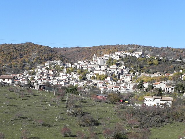
Аквавива-д'Изерния (Acquaviva d'Isernia, Acquaviva d'Isernia)
.svg)
- коммуна Италии
 Hiking in Аквавива-д'Изерния
Acquaviva d'Isernia is a lovely town situated in the Molise region of Italy, surrounded by beautiful landscapes that are ideal for hiking enthusiasts. The area offers a range of trails that cater to different skill levels, allowing hikers to explore its stunning natural beauty, historical sites, and charming villages.
Key Hiking Locations and Trails
-
Monti delle Mainarde: This mountain range located near Acquaviva d'Isernia offers various trails with breathtaking views. The terrain is a mix of rocky paths and lush greenery, making it perfect for intermediate to advanced hikers. The trails lead to panoramic viewpoints, where you can see the surrounding countryside and other peaks.
-
Cerro di Montenero: This area features trails that provide a moderate hike, suitable for families. These trails often pass through forests and alongside streams, offering a serene environment. The area is rich in flora and fauna, so keep your eyes peeled for local wildlife.
-
Ancient Ruins Hike: Venture on trails that link Acquaviva to the historical remains of ancient villages and churches. This hike can be easy to moderate and allows hikers to combine nature with cultural exploration.
-
Agriturismo Trails: Some trails wind through local agriturismo farms where you can sample regional cuisine and local wines. These hikes are usually less strenuous and focus on enjoying the landscape and local culture.
Tips for Hiking in Acquaviva d'Isernia
-
Best Time to Hike: Spring (April to June) and early autumn (September to October) are the ideal times for hiking. The weather is generally mild, and the landscapes are vibrant with blooming flowers or autumn colors.
-
Equipment: Wearing sturdy hiking boots is essential due to varying terrain. A walking stick may also be helpful for steeper trails.
-
Hydration and Snacks: Bring plenty of water and snacks, especially for longer hikes, as amenities might be sparse along the trails.
-
Local Guides: Consider hiring a local guide for specific trails or nature walks. They can provide valuable insights into the environment and history of the area.
-
Stay on Marked Trails: To preserve the natural habitat and ensure your safety, stick to marked trails.
Conclusion
Hiking in Acquaviva d'Isernia is an enchanting experience that combines the beauty of nature with rich cultural heritage. Whether you’re looking for a challenging trek or a leisurely walk, the area offers something for everyone. Always check local resources and maps for the latest trail information, and enjoy the breathtaking views and tranquil atmosphere!
- Страна:

- Почтовый код: 86080
- Телефонный код: 0865
- Код автомобильного номера: IS
- Координаты: 41° 40' 0" N, 14° 9' 0" E


- GPS треки (wikiloc): [Ссылка]
- Высота над уровнем моря: 730 м m
- Площадь: 13.51 кв.км
- Население: 413
- Веб сайт: http://www.comune.acquavivadisernia.is.it/
- Википедия русская: wiki(ru)
- Википедия английская: wiki(en)
- Википедия национальная: wiki(it)
- Хранилище Wikidata: Wikidata: Q278848
- Катеория в википедии: [Ссылка]
- код Freebase: [/m/0gqz_9]
- код GeoNames: Альт: [6537941]
- код VIAF: Альт: [144913529]
- ID отношения в OpenStreetMap: [41484]
- код ISTAT: 094001
- кадастровый код Италии: A051
Граничит с регионами:


Черро-аль-Вольтурно
- коммуна Италии
Hiking in Черро-аль-Вольтурно
Cerro al Volturno is a picturesque area located in the province of Isernia, in the Molise region of Italy. This destination is particularly popular among hikers and nature enthusiasts due to its stunning landscapes, rich biodiversity, and cultural heritage. Here’s what you can expect when hiking in and around Cerro al Volturno:...
- Страна:
- Почтовый код: 86072
- Телефонный код: 0865
- Код автомобильного номера: IS
- Координаты: 41° 39' 0" N, 14° 8' 0" E
- GPS треки (wikiloc): [Ссылка]
- Высота над уровнем моря: 572 м m
- Площадь: 23.79 кв.км
- Население: 1250
- Веб сайт: [Ссылка]

Форли-дель-Саннио
- коммуна Италии
Hiking in Форли-дель-Саннио
Forlì del Sannio is a charming village located in the Molise region of Italy, nestled in the Apennine Mountains. This area is known for its stunning natural landscapes, rich history, and excellent hiking opportunities. Here are some key points to consider if you're planning a hiking trip there:...
- Страна:
- Почтовый код: 86084
- Телефонный код: 0865
- Код автомобильного номера: IS
- Координаты: 41° 42' 0" N, 14° 11' 0" E
- GPS треки (wikiloc): [Ссылка]
- Высота над уровнем моря: 610 м m
- Площадь: 32.56 кв.км
- Население: 683
- Веб сайт: [Ссылка]

Монтенеро-Валь-Коккьяра
- коммуна Италии
Hiking in Монтенеро-Валь-Коккьяра
Montenero Val Cocchiara is a beautiful, lesser-known destination in the Italian region of Molise. Nestled in the Apennine Mountains, it offers a range of hiking opportunities surrounded by stunning natural scenery, quaint villages, and rich history. Here’s what you can expect when hiking in this area:...
- Страна:
- Почтовый код: 86080
- Телефонный код: 0865
- Код автомобильного номера: IS
- Координаты: 41° 43' 0" N, 14° 4' 0" E
- GPS треки (wikiloc): [Ссылка]
- Высота над уровнем моря: 893 м m
- Площадь: 22.02 кв.км
- Население: 514
- Веб сайт: [Ссылка]
Рьонеро-Саннитико
- коммуна Италии
Hiking in Рьонеро-Саннитико
Rionero Sannitico is a picturesque village located in the Molise region of Italy, surrounded by the stunning landscapes of the Apennine Mountains. Hiking in and around Rionero Sannitico offers a unique opportunity to explore both the natural beauty and the cultural heritage of this lesser-known area....
- Страна:
- Почтовый код: 86087
- Телефонный код: 0865
- Код автомобильного номера: IS
- Координаты: 41° 43' 0" N, 14° 8' 0" E
- GPS треки (wikiloc): [Ссылка]
- Высота над уровнем моря: 1051 м m
- Площадь: 29.22 кв.км
- Население: 1130
- Веб сайт: [Ссылка]