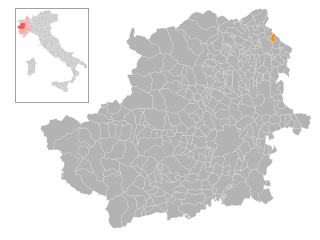
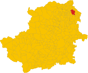
Кашинетте-д'Ивреа (Cascinette d'Ivrea, Cascinette d'Ivrea)

- коммуна Италии
 Hiking in Кашинетте-д'Ивреа
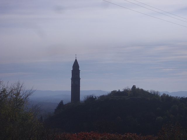
Cascinette d'Ivrea, located in the Piedmont region of northern Italy, is situated near the foothills of the Alps and offers beautiful landscapes and a variety of hiking opportunities. While it may not be as well-known as some larger hiking destinations, it provides a unique experience for outdoor enthusiasts.
Hiking Opportunities:
-
Scenic Trails: The area around Cascinette d'Ivrea features several scenic trails that typically take you through lush forests, rolling hills, and along rivers. The paths are often well-marked, making it a safe and enjoyable experience.
-
Natural Reserves: Nearby natural reserves, such as the Parco del Gran Paradiso, offer stunning hikes with breathtaking views of the Alps and diverse wildlife. There are a number of trails that range from easy family hikes to more challenging routes.
-
Historical Routes: Some trails may lead you to historical sites, including old churches, ruins, and traditional villages that showcase the rich culture of the region.
-
Seasonal Hiking: The best time for hiking in this area is typically from late spring to early autumn (May to October) when the weather is mild and the vistas are particularly beautiful.
Tips for Hiking in Cascinette d'Ivrea:
-
Check Local Maps: Before heading out, make sure to obtain local maps or guidebooks, as well-marked trails can sometimes change.
-
Prepare for Weather: Conditions can vary, especially in the mountains, so be prepared for different weather scenarios. Layered clothing is usually a good choice, as temperatures can change quickly.
-
Stay Hydrated and Nourished: Bring plenty of water and snacks, especially for longer hikes.
-
Respect Nature: Always follow Leave No Trace principles. Stay on marked trails, take your trash with you, and respect wildlife.
-
Safety First: If you're unsure of the trail difficulty or your hiking abilities, consider going with a local guide or joining a hiking group for a safer experience.
Overall, hiking in and around Cascinette d'Ivrea offers an excellent opportunity to enjoy the natural beauty of the Piedmont region, making it a worthwhile destination for hikers of all levels.
- Страна:

- Почтовый код: 10010
- Телефонный код: 0125
- Код автомобильного номера: TO
- Координаты: 45° 29' 0" N, 7° 54' 0" E


- GPS треки (wikiloc): [Ссылка]
- Высота над уровнем моря: 239 м m
- Площадь: 2.17 кв.км
- Население: 1531
- Веб сайт: http://www.comune.cascinette.to.it
- Википедия русская: wiki(ru)
- Википедия английская: wiki(en)
- Википедия национальная: wiki(it)
- Хранилище Wikidata: Wikidata: Q9198
- Катеория в википедии: [Ссылка]
- код Freebase: [/m/0g6typ]
- код GeoNames: Альт: [6542223]
- ID отношения в OpenStreetMap: [45122]
- код ISTAT: 001061
- кадастровый код Италии: B953
Граничит с регионами:

Буроло
- коммуна Италии
Hiking in Буроло
Burolo is a picturesque town located in the Piedmont region of Italy, surrounded by beautiful landscapes that make it an attractive destination for hiking enthusiasts. The area is characterized by its rolling hills, vineyards, and stunning views of the surrounding mountains, including the Alps....
- Страна:
- Почтовый код: 10010
- Телефонный код: 0125
- Код автомобильного номера: TO
- Координаты: 45° 29' 0" N, 7° 56' 0" E
- GPS треки (wikiloc): [Ссылка]
- Высота над уровнем моря: 300 м m
- Площадь: 5.48 кв.км
- Население: 1160
- Веб сайт: [Ссылка]

Кьяверано
- коммуна Италии
Hiking in Кьяверано
Chiaverano is a charming town located in the Canavese region of northern Italy, close to the foothills of the Alps. This area offers a blend of natural beauty, cultural heritage, and a variety of hiking opportunities for enthusiasts of all levels....
- Страна:
- Почтовый код: 10010
- Телефонный код: 0125
- Код автомобильного номера: TO
- Координаты: 45° 30' 0" N, 7° 54' 0" E
- GPS треки (wikiloc): [Ссылка]
- Высота над уровнем моря: 329 м m
- Площадь: 12.02 кв.км
- Население: 2073
- Веб сайт: [Ссылка]

Иврея
- коммуна Италии
Hiking in Иврея
Ivrea, a charming town located in the Piedmont region of northern Italy, offers a variety of hiking opportunities set against a backdrop of beautiful landscapes, mountains, and historical sites. Here are some highlights and tips for hiking in and around Ivrea:...
- Страна:
- Почтовый код: 10015
- Телефонный код: 0125
- Код автомобильного номера: TO
- Координаты: 45° 27' 44" N, 7° 52' 29" E
- GPS треки (wikiloc): [Ссылка]
- Высота над уровнем моря: 253 м m
- Площадь: 30.11 кв.км
- Население: 23637
- Веб сайт: [Ссылка]