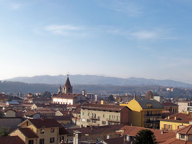
Фонтането-д'Агонья (Fontaneto d'Agogna, Fontaneto d'Agogna)
- коммуна Италии
 Hiking in Фонтането-д'Агонья
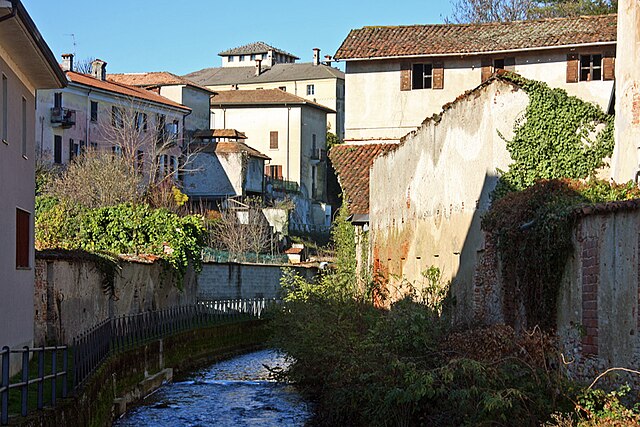
Fontaneto d'Agogna is a charming town located in the Novara province of Italy, nestled in the beautiful Piedmont region. The surrounding landscapes provide a variety of hiking opportunities that cater to different skill levels. Here are some key points to consider if you're planning a hike in this area:
Trails and Routes
- Natural Paths: Fontaneto d'Agogna has several natural paths that wind through its picturesque countryside, characterized by rolling hills, vineyards, and fields.
- Cultural Hikes: Some routes offer a mix of nature and culture, where you can explore local heritage sites, traditional farms, and historic buildings.
- Elevation Changes: The landscape has varying elevation, accommodating both gentle hikes suitable for families and more challenging routes for experienced hikers looking for a workout.
Suggested Hikes
- To the San Marco Monastery: A scenic route leading to the nearby San Marco Monastery, allowing hikers to immerse themselves in history as well as stunning views of the surrounding landscapes.
- Nature Reserves: Explore nearby nature reserves or parks that offer marked paths and opportunities for birdwatching and observing native flora and fauna.
Preparation
- Gear: Make sure to wear comfortable hiking shoes, and bring water, snacks, and a map of the routes or a GPS device as some trails may be less marked.
- Weather: Check the weather conditions before heading out, as the weather can change rapidly in mountainous regions.
- Local Recommendations: It can be helpful to chat with locals or visit the municipal office to gather up-to-date information on trail conditions and safety recommendations.
Safety Tips
- Stay on Trails: To preserve the natural beauty and minimize your impact, stay on marked trails.
- Hike with a Buddy: If possible, hike with a friend or in a group for added safety.
- Wildlife Precautions: Be aware of local wildlife; keep a respectful distance and do not feed animals.
Fontaneto d'Agogna offers a serene hiking experience amidst breathtaking natural beauty and rich culture, making it a lovely destination for outdoor enthusiasts. Make sure to plan your visit to enjoy the best of what this area has to offer!
- Страна:

- Почтовый код: 28010
- Телефонный код: 0322
- Код автомобильного номера: NO
- Координаты: 45° 39' 0" N, 8° 29' 0" E


- GPS треки (wikiloc): [Ссылка]
- Высота над уровнем моря: 260 м m
- Площадь: 21.17 кв.км
- Население: 2660
- Веб сайт: http://www.comune.fontaneto.no.it
- Википедия русская: wiki(ru)
- Википедия английская: wiki(en)
- Википедия национальная: wiki(it)
- Хранилище Wikidata: Wikidata: Q22266
- Катеория в википедии: [Ссылка]
- код Freebase: [/m/0g8s_p]
- код GeoNames: Альт: [6541447]
- код VIAF: Альт: [122391283]
- ID отношения в OpenStreetMap: [45509]
- код LCNAF: Альт: [no2009154617]
- UN/LOCODE: [ITFNT]
- код ISTAT: 003066
- кадастровый код Италии: D675
Граничит с регионами:
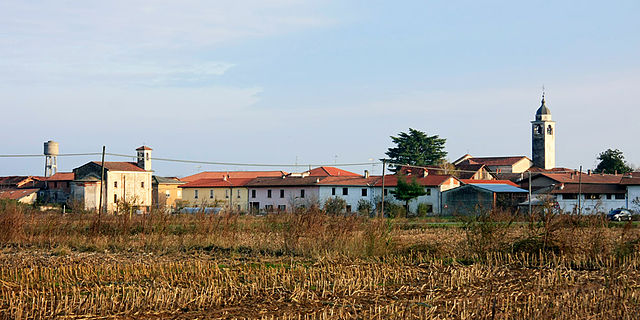
Боргоманеро
- коммуна Италии
Hiking in Боргоманеро
Borgomanero is a charming town located in the Piedmont region of Italy, near Lake Orta and the foothills of the Alps. The area offers a variety of hiking opportunities for outdoor enthusiasts, with trails that showcase stunning landscapes, rich biodiversity, and picturesque views....
- Страна:
- Почтовый код: 28021
- Телефонный код: 0322
- Код автомобильного номера: NO
- Координаты: 45° 42' 0" N, 8° 28' 0" E
- GPS треки (wikiloc): [Ссылка]
- Высота над уровнем моря: 306 м m
- Площадь: 32.27 кв.км
- Население: 21719
- Веб сайт: [Ссылка]
Кавальетто
- Коммуна в Италии, располагается в регионе Пьемонт, подчиняется административному центру Новара.
Hiking in Кавальетто
Cavaglietto is a charming village located in the Piedmont region of Italy, surrounded by beautiful landscapes that are perfect for hiking enthusiasts. The area offers a variety of trails catering to different skill levels, from easy walks to more challenging hikes in the surrounding hills and mountains....
- Страна:
- Почтовый код: 28010
- Телефонный код: 0322
- Код автомобильного номера: NO
- Координаты: 45° 36' 0" N, 8° 30' 0" E
- GPS треки (wikiloc): [Ссылка]
- Высота над уровнем моря: 233 м m
- Площадь: 6.49 кв.км
- Население: 383
- Веб сайт: [Ссылка]

Кавальо-д'Агонья
- Коммуна в Италии, располагается в регионе Пьемонт, подчиняется административному центру Новара.
Hiking in Кавальо-д'Агонья
Cavaglio d'Agogna is a small village located in the Piedmont region of Italy, and it serves as a great base for exploring the natural beauty and hiking opportunities in the surrounding area. The region is characterized by its picturesque landscapes, rolling hills, and proximity to the Sesia Valley and the mountains of the nearby Ossola Valley....
- Страна:
- Почтовый код: 28010
- Телефонный код: 0322
- Код автомобильного номера: NO
- Координаты: 45° 37' 0" N, 8° 29' 0" E
- GPS треки (wikiloc): [Ссылка]
- Высота над уровнем моря: 243 м m
- Площадь: 9.83 кв.км
- Население: 1174
- Веб сайт: [Ссылка]

Каваллирио
- Коммуна в Италии, располагается в регионе Пьемонт, подчиняется административному центру Новара.
Hiking in Каваллирио
Cavallirio is a charming village located in the Piedmont region of Italy, nestled in the hills near Lake Orta and not far from the larger Lake Maggiore. It offers a range of hiking opportunities, thanks to its scenic landscape that features rolling hills, forests, and breathtaking views of the surrounding countryside....
- Страна:
- Почтовый код: 28010
- Телефонный код: 0163
- Код автомобильного номера: NO
- Координаты: 45° 39' 44" N, 8° 23' 44" E
- GPS треки (wikiloc): [Ссылка]
- Высота над уровнем моря: 367 м m
- Площадь: 8.33 кв.км
- Население: 1335
- Веб сайт: [Ссылка]

Кресса
- коммуна Италии
Hiking in Кресса
Cressa is a charming area located in the province of Novara in the Piedmont region of Italy. While it may not be as well-known for hiking as some other regions, it offers a beautiful countryside with trails that can be enjoyable for both beginners and experienced hikers....
- Страна:
- Почтовый код: 28012
- Телефонный код: 0322
- Код автомобильного номера: NO
- Координаты: 45° 39' 0" N, 8° 31' 0" E
- GPS треки (wikiloc): [Ссылка]
- Высота над уровнем моря: 267 м m
- Площадь: 7.1 кв.км
- Население: 1612
- Веб сайт: [Ссылка]

Куреджо
- Коммуна в Италии, располагается в регионе Пьемонт, подчиняется административному центру Новара.
Hiking in Куреджо
Cureggio is a small municipality located in the Piedmont region of Italy, close to the beautiful Lake Orta. While it may not be as well-known as other hiking destinations, it offers enchanting landscapes, tranquil trails, and the charm of rural Italy....
- Страна:
- Почтовый код: 28060
- Телефонный код: 0322
- Код автомобильного номера: NO
- Координаты: 45° 41' 0" N, 8° 28' 0" E
- GPS треки (wikiloc): [Ссылка]
- Высота над уровнем моря: 289 м m
- Площадь: 8.51 кв.км
- Население: 2630
- Веб сайт: [Ссылка]
Гемме
- коммуна Италии
Hiking in Гемме
Ghemme, located in the Piedmont region of northern Italy, is surrounded by beautiful landscapes and a rich cultural heritage, making it an excellent destination for hiking enthusiasts....
- Страна:
- Почтовый код: 28074
- Телефонный код: 0163
- Код автомобильного номера: NO
- Координаты: 45° 36' 0" N, 8° 25' 0" E
- GPS треки (wikiloc): [Ссылка]
- Высота над уровнем моря: 241 м m
- Площадь: 20.64 кв.км
- Население: 3573
- Веб сайт: [Ссылка]
Романьяно-Сезия
- коммуна Италии
Hiking in Романьяно-Сезия
Romagnano Sesia is a charming town located in the Piedmont region of northern Italy, surrounded by scenic landscapes that offer excellent opportunities for hiking and outdoor activities. Here are some aspects of hiking in and around Romagnano Sesia:...
- Страна:
- Почтовый код: 28078
- Телефонный код: 0163
- Код автомобильного номера: NO
- Координаты: 45° 38' 0" N, 8° 23' 0" E
- GPS треки (wikiloc): [Ссылка]
- Высота над уровнем моря: 266 м m
- Площадь: 17.98 кв.км
- Население: 3889
- Веб сайт: [Ссылка]
Суно
- коммуна Италии
Hiking in Суно
Suno is not widely recognized as a specific hiking destination, so it's possible you might be referring to a local or lesser-known area. However, if you're talking about hiking in general or a place similar to "Suno," I can provide some general guidance on what to look for in a hiking location and tips for your hikes....
- Страна:
- Почтовый код: 28019
- Телефонный код: 0322
- Код автомобильного номера: NO
- Координаты: 45° 38' 0" N, 8° 32' 0" E
- GPS треки (wikiloc): [Ссылка]
- Высота над уровнем моря: 250 м m
- Площадь: 21.33 кв.км
- Население: 2788
- Веб сайт: [Ссылка]