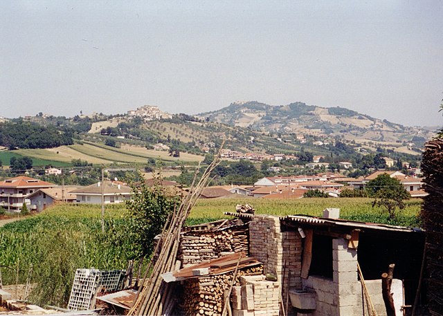
Пенна-Сант'Андреа (Penna Sant'Andrea, Penna Sant'Andrea)
.svg)
- коммуна Италии
 Hiking in Пенна-Сант'Андреа
Penna Sant'Andrea, located in the Abruzzo region of Italy, is a hidden gem for hiking enthusiasts. Nestled in the picturesque Apennine Mountains, this area offers stunning landscapes, rich biodiversity, and a range of hiking trails suitable for different skill levels.
Hiking Trails
-
Sentiero del Lupo (Wolf Trail): This trail is known for its beautiful scenery and the chance to spot wildlife, including wolves, in their natural habitat. The trail offers a moderate hike with varying terrain, making it suitable for most hikers.
-
Cima del Muro: A more challenging hike, this trail leads you to one of the highest points in the region. The views from the summit are breathtaking, showcasing the rolling hills and valleys of Abruzzo.
-
Piana dei Venti: This trail provides a beautiful walk through alpine meadows, where you can enjoy the local flora and fauna. It's ideal for families and less experienced hikers.
Best Time to Hike
The best time to visit Penna Sant'Andrea for hiking is during the spring (April to June) and early autumn (September to October). The weather is usually mild, and the trails are less crowded. Summer can be hot, and winter months may bring snow, which can make hiking more challenging.
Essential Tips
-
Preparation: Always check the weather forecast and trail conditions before heading out. Carry a map or a GPS device, as some trails can be less marked.
-
Water and Snacks: Bring plenty of water, especially on longer hikes, and pack snacks to keep your energy up.
-
Local Regulations: Be aware of local regulations regarding wildlife and preserve the natural environment by practicing Leave No Trace principles.
-
Gear: Wear sturdy hiking boots and appropriate clothing for the conditions. Layers are recommended, as temperatures can vary throughout the day.
Conclusion
Hiking in Penna Sant'Andrea offers a chance to experience Italy's natural beauty and tranquility. With its diverse trails and stunning vistas, it's a wonderful destination for both novice and experienced hikers. Make sure to take your time to enjoy the scenery and maybe even discover some local culture along the way!
- Страна:

- Почтовый код: 64039
- Телефонный код: 0861
- Код автомобильного номера: TE
- Координаты: 42° 36' 0" N, 13° 46' 0" E


- GPS треки (wikiloc): [Ссылка]
- Высота над уровнем моря: 413 м m
- Площадь: 11.1 кв.км
- Население: 1763
- Веб сайт: http://www.psa.it/
- Википедия русская: wiki(ru)
- Википедия английская: wiki(en)
- Википедия национальная: wiki(it)
- Хранилище Wikidata: Wikidata: Q51459
- Катеория в википедии: [Ссылка]
- код Freebase: [/m/0fs47w]
- код GeoNames: Альт: [6538859]
- ID отношения в OpenStreetMap: [42081]
- код ISTAT: 067033
- кадастровый код Италии: G437
Граничит с регионами:

Терамо
- коммуна Италии
Hiking in Терамо
Teramo, located in the Abruzzo region of Italy, is an excellent destination for hiking enthusiasts. The area is characterized by its diverse landscapes, which include rugged mountains, rolling hills, and beautiful coastlines. Here are some highlights and considerations for hiking in and around Teramo:...
- Страна:
- Почтовый код: 64100
- Телефонный код: 0861
- Код автомобильного номера: TE
- Координаты: 42° 39' 32" N, 13° 42' 14" E
- GPS треки (wikiloc): [Ссылка]
- Высота над уровнем моря: 265 м m
- Площадь: 153 кв.км
- Население: 54857
- Веб сайт: [Ссылка]
Башано
- коммуна Италии
Hiking in Башано
Basciano is a small town located in the Abruzzo region of Italy. While it may not be as widely known for hiking as some larger areas, it is surrounded by beautiful landscapes typical of the Abruzzo region, which is known for its natural parks, mountains, and outdoor activities....
- Страна:
- Почтовый код: 64030
- Телефонный код: 0861
- Код автомобильного номера: TE
- Координаты: 42° 35' 47" N, 13° 44' 8" E
- GPS треки (wikiloc): [Ссылка]
- Высота над уровнем моря: 388 м m
- Площадь: 18.85 кв.км
- Население: 2373
- Веб сайт: [Ссылка]

Кастель-Кастанья
- коммуна Италии
Hiking in Кастель-Кастанья
Castel Castagna is a picturesque village located in the Teramo province of the Abruzzo region in Italy. Known for its stunning landscapes and rich natural heritage, it offers a variety of hiking opportunities for outdoor enthusiasts....
- Страна:
- Почтовый код: 64030
- Телефонный код: 0861
- Код автомобильного номера: TE
- Координаты: 42° 33' 0" N, 13° 43' 0" E
- GPS треки (wikiloc): [Ссылка]
- Высота над уровнем моря: 452 м m
- Площадь: 18.16 кв.км
- Население: 490
- Веб сайт: [Ссылка]

Черминьано
- коммуна Италии
Hiking in Черминьано
Cermignano, a charming town located in the Teramo province of Italy, offers a unique blend of natural beauty and cultural heritage. Here are some aspects to consider for hiking in and around Cermignano:...
- Страна:
- Почтовый код: 64037
- Телефонный код: 0861
- Код автомобильного номера: TE
- Координаты: 42° 35' 0" N, 13° 48' 0" E
- GPS треки (wikiloc): [Ссылка]
- Высота над уровнем моря: 563 м m
- Площадь: 26.36 кв.км
- Население: 1591
- Веб сайт: [Ссылка]