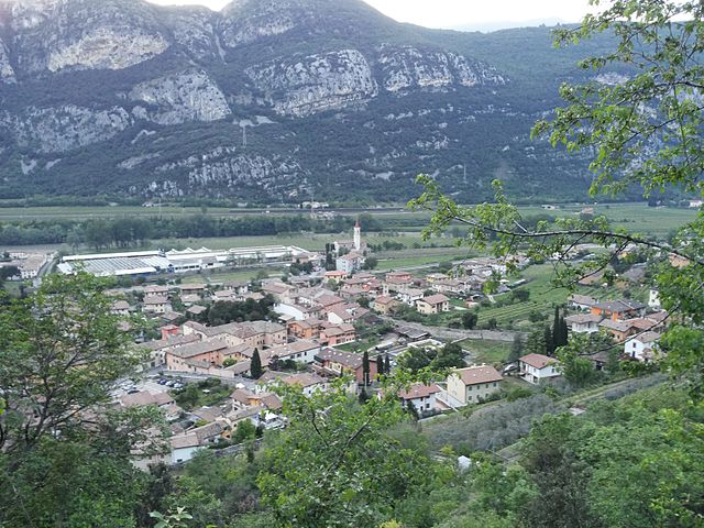
Сант'Амброджо-ди-Вальполичелла (Sant'Ambrogio di Valpolicella, Sant'Ambrogio di Valpolicella)
- коммуна Италии
 Hiking in Сант'Амброджо-ди-Вальполичелла
Sant'Ambrogio di Valpolicella is a picturesque commune located in the Veneto region of Italy, known for its stunning landscapes, vineyards, and hiking trails that traverse the hills and valleys of the Valpolicella wine region. Here are some highlights and tips for hiking in this area:
Scenery and Terrain
- Rolling Hills and Vineyards: The terrain is characterized by vineyards, olive groves, and gentle hills, providing beautiful views and a serene atmosphere. The nearby mountains also offer more rugged hiking opportunities.
- Natural Beauty: The area boasts a variety of flora and fauna, along with breathtaking vistas of the surrounding countryside, especially during sunrise and sunset.
Hiking Trails
- Valpolicella Trails: There are numerous trails that can vary in difficulty, from easy walks through vineyards to more challenging hikes that lead up to panoramic viewpoints. One popular route is the “Sentiero della Valpolicella,” which connects various villages and offers scenic views along the way.
- Monte della Madonna: A hike leading to the peak provides grand vistas of the surrounding area and is a great option for those looking for something more strenuous.
- Local Guidance: It's often useful to consult local maps or visitor centers to find detailed trail information, as well as any seasonal conditions that may affect hiking.
Preparation Tips
- Footwear: Wear sturdy hiking shoes or boots for comfort and support, especially on uneven terrain.
- Weather Conditions: The weather can vary, so check forecasts and be prepared with appropriate clothing. Summers can be hot while springs and autumns are usually mild but may bring rain.
- Hydration and Snacks: Bring plenty of water and some snacks, especially if you plan on hiking longer trails.
Local Culture and Attractions
- Wine Tasting: After hiking, visitors can enjoy wine tastings at local wineries that produce renowned Valpolicella wines, including Amarone and Ripasso.
- Historical Sites: Explore the charming old town of Sant'Ambrogio di Valpolicella and nearby historical landmarks like ancient churches and villas.
- Cuisine: Taste local dishes at restaurants that serve traditional Veneto cuisine, making for a perfect way to end a day of hiking.
Getting There
- Accessibility: Sant'Ambrogio di Valpolicella is easily accessible by car from Verona, which is the nearest major city. Public transportation options may also be available, although having a car can offer more flexibility to explore various trails.
Hiking in Sant'Ambrogio di Valpolicella provides not only a chance to enjoy the great outdoors but also an opportunity to immerse yourself in the rich culture and beauty of this enchanting region of Italy. Be sure to follow local conservation guidelines to help preserve the natural environment for future hikers!
- Страна:

- Почтовый код: 37015
- Телефонный код: 045
- Код автомобильного номера: VR
- Координаты: 45° 31' 0" N, 10° 50' 0" E


- GPS треки (wikiloc): [Ссылка]
- Высота над уровнем моря: 174 м m
- Площадь: 23.5 кв.км
- Население: 11818
- Веб сайт: http://www.comune.santambrogio.vr.it/
- Википедия русская: wiki(ru)
- Википедия английская: wiki(en)
- Википедия национальная: wiki(it)
- Хранилище Wikidata: Wikidata: Q47513
- Галерея изображений в википедии: [Ссылка]
- Катеория в википедии: [Ссылка]
- код Freebase: [/m/0gb365]
- код GeoNames: Альт: [6536209]
- код VIAF: Альт: [125637734]
- ID отношения в OpenStreetMap: [45203]
- код GND: Альт: [4376314-5]
- код LCNAF: Альт: [n93065581]
- WOEID: [12679101]
- UN/LOCODE: [ITXAV]
- код Trismegistos: [31379]
- код ISTAT: 023077
- кадастровый код Италии: I259
Граничит с регионами:


Фумане
- коммуна Италии
Hiking in Фумане
Fumane is a charming area located in the Veneto region of northern Italy, known for its beautiful landscapes, vineyards, and rich archaeological history. It is situated near the Valpolicella region, which is famous for its wine production, and close to the natural wonder of the Lessinia Plateau....
- Страна:
- Почтовый код: 37022
- Телефонный код: 045
- Код автомобильного номера: VR
- Координаты: 45° 32' 35" N, 10° 52' 54" E
- GPS треки (wikiloc): [Ссылка]
- Высота над уровнем моря: 198 м m
- Площадь: 34.21 кв.км
- Население: 4151
- Веб сайт: [Ссылка]

Дольче
- коммуна Италии
Hiking in Дольче
Dolcè is a small village located in the province of Verona, Italy, nestled in the beautiful surroundings of the Lessinia Regional Park. This area is characterized by its stunning landscapes, charming rural architecture, and a variety of hiking trails that cater to different skill levels. Here are some key points about hiking in Dolcè:...
- Страна:
- Почтовый код: 37020
- Телефонный код: 045
- Код автомобильного номера: VR
- Координаты: 45° 36' 0" N, 10° 51' 0" E
- GPS треки (wikiloc): [Ссылка]
- Высота над уровнем моря: 115 м m
- Площадь: 30.95 кв.км
- Население: 2575
- Веб сайт: [Ссылка]


Риволи-Веронезе
- коммуна Италии
Hiking in Риволи-Веронезе
Rivoli Veronese, located in the province of Verona in northern Italy, offers a charming mix of natural beauty and historical significance, making it an excellent destination for hiking. Nestled within the picturesque landscape of the Lessinia Regional Park, the area features a variety of trails that cater to different skill levels....
- Страна:
- Почтовый код: 37010
- Телефонный код: 045
- Код автомобильного номера: VR
- Координаты: 45° 34' 0" N, 10° 49' 0" E
- GPS треки (wikiloc): [Ссылка]
- Высота над уровнем моря: 191 м m
- Площадь: 18.43 кв.км
- Население: 2210
- Веб сайт: [Ссылка]


Сан-Пьетро-ин-Карьяно
- коммуна Италии
Hiking in Сан-Пьетро-ин-Карьяно
San Pietro in Cariano is a charming town located in the province of Verona, in the Veneto region of Italy. Nestled amidst the picturesque hills of the Valpolicella wine region, it offers various hiking opportunities with stunning views of vineyards, olive groves, and the surrounding countryside....
- Страна:
- Почтовый код: 37029
- Телефонный код: 045
- Код автомобильного номера: VR
- Координаты: 45° 31' 0" N, 10° 53' 0" E
- GPS треки (wikiloc): [Ссылка]
- Высота над уровнем моря: 151 м m
- Площадь: 20.24 кв.км
- Население: 12930
- Веб сайт: [Ссылка]

Пескантина
- коммуна Италии
Hiking in Пескантина
Pescantina is a charming village located in the Veneto region of Italy, just a few kilometers from Verona and close to the scenic shores of Lake Garda. The area surrounding Pescantina offers various hiking opportunities, characterized by picturesque landscapes, vineyards, and scenic trails....
- Страна:
- Почтовый код: 37026
- Телефонный код: 045
- Код автомобильного номера: VR
- Координаты: 45° 29' 0" N, 10° 52' 0" E
- GPS треки (wikiloc): [Ссылка]
- Высота над уровнем моря: 80 м m
- Площадь: 19.73 кв.км
- Население: 17236
- Веб сайт: [Ссылка]
Кавайон-Веронезе
- коммуна Италии
Hiking in Кавайон-Веронезе
Cavaion Veronese is a picturesque village located in the Veneto region of Italy, not far from Lake Garda. The surrounding area offers a variety of hiking opportunities with beautiful views of the lake, rolling hills, vineyards, and rural landscapes....
- Страна:
- Почтовый код: 37010
- Телефонный код: 045
- Код автомобильного номера: VR
- Координаты: 45° 32' 24" N, 10° 46' 14" E
- GPS треки (wikiloc): [Ссылка]
- Высота над уровнем моря: 190 м m
- Площадь: 12.91 кв.км
- Население: 5924
- Веб сайт: [Ссылка]


Пастренго
- коммуна Италии
Hiking in Пастренго
Pastrengo, located in the Veneto region of Italy near Lake Garda, offers a variety of hiking opportunities. The area features beautiful landscapes, including rolling hills, vineyards, and historical sites, making it an excellent destination for hikers of all experience levels....
- Страна:
- Почтовый код: 37010
- Телефонный код: 045
- Код автомобильного номера: VR
- Координаты: 45° 30' 0" N, 10° 48' 0" E
- GPS треки (wikiloc): [Ссылка]
- Высота над уровнем моря: 192 м m
- Площадь: 9 кв.км
- Население: 3092
- Веб сайт: [Ссылка]