Эугст-на-Альбисе (Aeugst am Albis, Aeugst am Albis)

 Hiking in Эугст-на-Альбисе
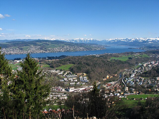
Äugst am Albis is a picturesque municipality located in the canton of Zurich, Switzerland, offering a variety of hiking opportunities that showcase the beauty of the Swiss landscape. As a hiking instructor, here’s what you should know about hiking in this area:
Overview:
- Scenic Trails: The area is characterized by lush forests, rolling hills, and stunning views of the surrounding mountains, including the nearby Albis range.
- Accessibility: Äugst am Albis is easily accessible from Zurich, making it an excellent destination for both day hikes and longer excursions.
- Trail Difficulty: There is a range of trails suited for different skill levels, from easy walks suitable for families to more challenging hikes for experienced trekkers.
Popular Hikes:
-
Sihlwald: Starting from Äugst am Albis, you can hike into the Sihlwald forest. This area features well-marked trails and can be combined with longer routes along the Sihl River.
-
Uetliberg Mountain: A popular hike leading to the Uetliberg summit offers panoramic views of Zurich and beyond. The trail to the Uetliberg from Äugst is well-marked and provides a challenging but rewarding experience.
-
Albis Ridge: For a longer day hike, follow the Albis Ridge trail, which connects various viewing points along the ridge and offers breathtaking vistas of the Zurich area and the Alps on clear days.
Tips for Hiking:
- Equipment: Make sure to wear sturdy hiking boots and bring appropriate clothing, as weather can change quickly in the mountains.
- Trail Maps: Consider carrying a trail map or using a reliable hiking app to stay on track, especially if you venture into less-marked paths.
- Stay Hydrated: Pack enough water, especially during warmer months, and consider bringing snacks for longer hikes.
- Respect Nature: Follow Leave No Trace principles, keeping the trails clean and respecting wildlife.
Local Amenities:
- Public Transport: The area is well-connected by public transport, making it convenient to reach hiking trailheads.
- Food Options: After a hike, you may find local restaurants offering delicious Swiss cuisine in Äugst am Albis.
Conclusion:
Hiking in Äugst am Albis provides a wonderful opportunity to experience the natural beauty of Switzerland. From leisurely strolls through serene forests to challenging mountain hikes, there is something for everyone in this beautiful region. Be sure to check local conditions and trail information before heading out, and enjoy your adventure!
- Страна:

- Телефонный код: 044
- Код автомобильного номера: ZH
- Координаты: 47° 16' 3" N, 8° 29' 7" E


- GPS треки (wikiloc): [Ссылка]
- Высота над уровнем моря: 696 м m
- Площадь: 7.87 кв.км
- Население: 1941
- Веб сайт: http://www.aeugst-albis.ch
- Википедия русская: wiki(ru)
- Википедия английская: wiki(en)
- Википедия национальная: wiki(de)
- Хранилище Wikidata: Wikidata: Q64945
- Катеория в википедии: [Ссылка]
- код Freebase: [/m/0f3fsp]
- код GeoNames: Альт: [7285035]
- код VIAF: Альт: [245831727]
- ID отношения в OpenStreetMap: [1682079]
- идентификатор HDS: [1]
- код швейцарского муниципалитета: [0001]
Граничит с регионами:


Хаузен-на-Альбисе
Hiking in Хаузен-на-Альбисе
Hausen am Albis is a picturesque village located in the Canton of Zurich, Switzerland. It is surrounded by beautiful landscapes, making it an ideal destination for hiking enthusiasts. Here’s a guide to hiking in this charming area:...
- Страна:
- Почтовый код: 8915
- Телефонный код: 044; 043
- Код автомобильного номера: ZH
- Координаты: 47° 14' 41" N, 8° 32' 4" E
- GPS треки (wikiloc): [Ссылка]
- Высота над уровнем моря: 611 м m
- Площадь: 13.64 кв.км
- Население: 3646
- Веб сайт: [Ссылка]

Лангнау-на-Альбисе
Hiking in Лангнау-на-Альбисе
Langnau am Albis, located in the canton of Zurich, Switzerland, is a beautiful area for hiking, offering a mix of scenic landscapes, forests, and panoramic views of the surrounding Alps and Lake Zurich. Here are some highlights and tips for hiking in this region:...
- Страна:
- Почтовый код: 8135
- Телефонный код: 01
- Код автомобильного номера: ZH
- Координаты: 47° 17' 22" N, 8° 32' 29" E
- GPS треки (wikiloc): [Ссылка]
- Высота над уровнем моря: 468 м m
- Площадь: 8.66 кв.км
- Население: 7500
- Веб сайт: [Ссылка]