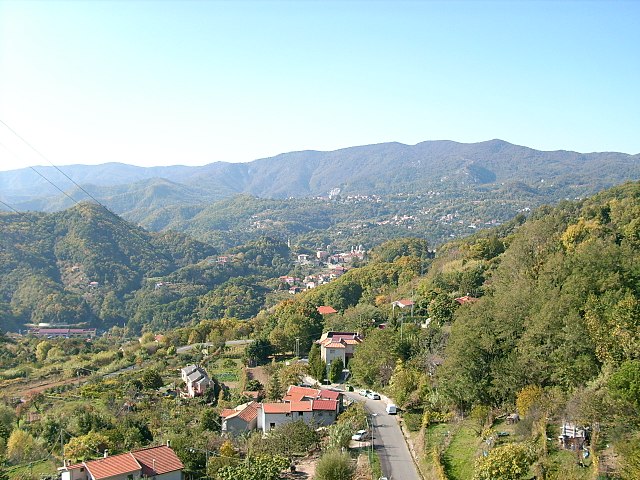
Альбизола-Суперьоре (Albisola Superiore, Albisola Superiore)
.svg)
- коммуна Италии
 Hiking in Альбизола-Суперьоре
Albisola Superiore, located in the Liguria region of Italy, is a beautiful destination for hiking enthusiasts. Nestled along the Italian Riviera, it offers picturesque landscapes, coastal views, and a range of trails suitable for different skill levels. Here’s an overview of what you can expect when hiking in this area:
Trails and Routes
-
Coastal Trails: Many trails run along the coastline, providing stunning views of the Ligurian Sea. These trails are typically easy to moderate, perfect for those who appreciate scenic walks and accessibility.
-
Hiking in the Hills: Just inland from the coast, you’ll find more challenging hikes that take you through lush vegetation, vineyards, and olive groves. The views from the higher elevations can be particularly rewarding.
-
Regional Park of Monte Beigua: Just a short drive away, this park offers a more extensive network of hiking trails that vary in difficulty. You can explore diverse ecosystems, wildlife, and panoramic views.
Points of Interest
- Architectural Wonders: While hiking, you might come across historical landmarks, churches, and traditional Ligurian village architecture, adding cultural significance to your outdoor pursuits.
- Local Flora and Fauna: The region is home to diverse plant and animal species, making it interesting for nature lovers. Be sure to look out for local wildlife along the trails.
Best Times to Hike
- Spring and Fall: These seasons offer mild weather and fewer crowds. The landscapes are particularly beautiful with blooming flowers in spring and autumn foliage.
- Summer: Summer can be hot, but early morning or late afternoon hikes can be quite pleasant.
Tips
- Stay Hydrated: Always bring enough water, especially if hiking during the warmer months.
- Proper Gear: Wear suitable hiking shoes and consider bringing hiking poles for more challenging trails.
- Navigation: Carry a map or use a GPS app to stay on track, as some trails may not be well marked.
Local Amenities
After a day of hiking, you can enjoy local cuisine in nearby restaurants or cafes specializing in Ligurian dishes, including fresh seafood and pasta. This is also a great opportunity to relax and recount the day’s adventures.
Whether you're an experienced hiker or just looking for a leisurely walk with beautiful views, Albisola Superiore offers a wonderful hiking experience amid the beauty of the Italian Riviera.
- Страна:

- Почтовый код: 17011
- Телефонный код: 019
- Код автомобильного номера: SV
- Координаты: 44° 20' 22" N, 8° 30' 36" E


- GPS треки (wikiloc): [Ссылка]
- Высота над уровнем моря: 10 м m
- Площадь: 28.68 кв.км
- Население: 10033
- Веб сайт: http://www.comune.albisola-superiore.sv.it/
- Википедия русская: wiki(ru)
- Википедия английская: wiki(en)
- Википедия национальная: wiki(it)
- Хранилище Wikidata: Wikidata: Q270492
- Галерея изображений в википедии: [Ссылка]
- Катеория в википедии: [Ссылка]
- код Freebase: [/m/0gbzbr]
- код GeoNames: Альт: [3183313]
- код VIAF: Альт: [316737262]
- ID отношения в OpenStreetMap: [43051]
- идентификатор местоположения ArchINFORM: [16418]
- место в MusicBrainz: [02789164-ac9b-48c1-a96f-caec22123ac7]
- код TGN: [7005384]
- UN/LOCODE: [ITASU]
- код ISTAT: 009004
- кадастровый код Италии: A166
Граничит с регионами:


Савона
- коммуна Италии
Hiking in Савона
Hiking in Savona, a charming coastal city in northwest Italy, offers a blend of stunning seascapes, lush landscapes, and historical sites. The area is part of the Liguria region, known for its picturesque cliffs, olive groves, and Mediterranean climate....
- Страна:
- Почтовый код: 17100
- Телефонный код: 019
- Код автомобильного номера: SV
- Координаты: 44° 18' 29" N, 8° 28' 52" E
- GPS треки (wikiloc): [Ссылка]
- Высота над уровнем моря: 4 м m
- Площадь: 65.32 кв.км
- Население: 61057
- Веб сайт: [Ссылка]


Альбиссола-Марина
- коммуна Италии
Hiking in Альбиссола-Марина
Albissola Marina, located on the beautiful Ligurian coast of Italy, is known for its picturesque views, charming architecture, and proximity to the Italian Riviera. While it is primarily a coastal town, there are several hiking opportunities nearby that allow you to explore the stunning natural landscapes of the region....
- Страна:
- Почтовый код: 17012
- Телефонный код: 019
- Код автомобильного номера: SV
- Координаты: 44° 19' 51" N, 8° 30' 35" E
- GPS треки (wikiloc): [Ссылка]
- Высота над уровнем моря: 3 м m
- Площадь: 3.25 кв.км
- Население: 5387
- Веб сайт: [Ссылка]


Кайро-Монтенотте
- коммуна Италии
Hiking in Кайро-Монтенотте
Cairo Montenotte, located in the Liguria region of Italy, is surrounded by beautiful natural landscapes, making it a delightful destination for hiking enthusiasts. The area offers a variety of trails that cater to different skill levels, from leisurely walks to more challenging treks....
- Страна:
- Почтовый код: 17014
- Телефонный код: 019
- Код автомобильного номера: SV
- Координаты: 44° 23' 52" N, 8° 16' 40" E
- GPS треки (wikiloc): [Ссылка]
- Высота над уровнем моря: 330 м m
- Площадь: 100.4 кв.км
- Население: 13145
- Веб сайт: [Ссылка]


Челле-Лигуре
- коммуна Италии
Hiking in Челле-Лигуре
Celle Ligure, located in the Italian region of Liguria, is a charming coastal town known for its beautiful beaches and picturesque scenery. The area surrounding Celle Ligure offers a variety of hiking opportunities that can cater to different skill levels and interests....
- Страна:
- Почтовый код: 17015
- Телефонный код: 019
- Код автомобильного номера: SV
- Координаты: 44° 20' 32" N, 8° 32' 44" E
- GPS треки (wikiloc): [Ссылка]
- Высота над уровнем моря: 4 м m
- Площадь: 9.56 кв.км
- Население: 5184
- Веб сайт: [Ссылка]


Понтинвреа
- коммуна Италии
Hiking in Понтинвреа
Pontinvrea, located in the Liguria region of Italy, offers a variety of hiking opportunities that showcase its beautiful landscapes and rich biodiversity. Here are some key points to consider if you're planning a hike in this area:...
- Страна:
- Почтовый код: 17042
- Телефонный код: 019
- Код автомобильного номера: SV
- Координаты: 44° 26' 41" N, 8° 26' 5" E
- GPS треки (wikiloc): [Ссылка]
- Высота над уровнем моря: 425 м m
- Площадь: 24.95 кв.км
- Население: 829
- Веб сайт: [Ссылка]

Стелла
- коммуна Италии
Hiking in Стелла
Stella is a beautiful municipality located in the province of Savona in the Liguria region of Italy. Nestled in the scenic hills near the coastline, Stella offers a variety of hiking opportunities that cater to different skill levels, making it a great spot for outdoor enthusiasts....
- Страна:
- Почтовый код: 17044
- Телефонный код: 019
- Код автомобильного номера: SV
- Координаты: 44° 23' 49" N, 8° 29' 36" E
- GPS треки (wikiloc): [Ссылка]
- Высота над уровнем моря: 266 м m
- Площадь: 43.68 кв.км
- Население: 3006
- Веб сайт: [Ссылка]