Андон (Andon, Andon)

- коммуна в департаменте Приморские Альпы, регион Прованс — Альпы — Лазурный Берег, Франция
 Hiking in Андон
Andon, located in the Alpes-Maritimes region of France, is a charming village that offers a range of hiking opportunities amidst stunning natural landscapes. Nestled in the foothills of the Alpes, it serves as a gateway to the surrounding mountains and valleys. Here are some highlights and tips for hiking in and around Andon:
Hiking Trails:
-
Sentier des Côtiers: This coastal path offers breathtaking views of the surrounding valleys and is suitable for various skill levels. It’s a great way to enjoy the alpine flora and fauna.
-
Les Gorges de la Loup: A short drive from Andon, this area offers several trails that allow hikers to explore the dramatic gorges, waterfalls, and unique rock formations.
-
Col de l'Escudelle: This hike provides panoramic views of the surrounding peaks and valleys. The trail can be moderately challenging but rewards hikers with beautiful vistas.
-
Les Baous de Saint-Jeannet: A bit farther afield, these iconic limestone cliffs are a popular hiking destination. Trails vary in difficulty and length, providing options for both novice and experienced hikers.
Best Time to Hike:
- Spring (March to June): Ideal for enjoying wildflowers and moderate temperatures.
- Fall (September to November): Offers vibrant autumn colors and cooler hiking conditions.
- Summer (July-August): While warmer, early morning hikes can be delightful; just prepare for possible afternoon thunderstorms.
Accessibility:
Andon is primarily accessible by car, and the trails usually have designated parking areas. Public transportation options may be limited, so it’s advisable to have your own vehicle for flexibility.
Tips for Hiking in Andon:
- Preparation: Bring enough water, snacks, and a map or GPS device. Some trails may not be well marked, so it’s advisable to familiarize yourself with the route beforehand.
- Footwear: Wear sturdy hiking boots with good traction, as trails can be rocky or uneven.
- Weather Conditions: Always check the weather forecast before heading out. The weather can change rapidly in the mountains.
- Wildlife: Be respectful of the local wildlife and make sure to follow Leave No Trace principles.
Local Attractions:
After a day of hiking, consider exploring the village of Andon itself. It’s known for its charming streets, local cuisine, and inviting atmosphere.
Whether you’re an experienced hiker or a casual walker, Andon offers a picturesque setting to enjoy nature and the stunning landscapes of the Alpes-Maritimes.
- Страна:

- Почтовый код: 06750
- Координаты: 43° 46' 23" N, 6° 47' 11" E


- GPS треки (wikiloc): [Ссылка]
- Площадь: 54.3 кв.км
- Население: 562
- Веб сайт: http://www.ville-andon.com
- Википедия русская: wiki(ru)
- Википедия английская: wiki(en)
- Википедия национальная: wiki(fr)
- Хранилище Wikidata: Wikidata: Q841565
- Катеория в википедии: [Ссылка]
- код Freebase: [/m/03m4z0f]
- код Freebase: [/m/03m4z0f]
- код GeoNames: Альт: [3037705]
- код GeoNames: Альт: [3037705]
- номер SIREN: [210600037]
- номер SIREN: [210600037]
- WOEID: [576073]
- WOEID: [576073]
- код муниципалитета INSEE: 06003
- код муниципалитета INSEE: 06003
Граничит с регионами:


Кай
- коммуна в департаменте Приморские Альпы, регион Прованс — Альпы — Лазурный Берег, Франция
Hiking in Кай
Caille is a charming village located in the Alpes-Maritimes department of the Provence-Alpes-Côte d'Azur region in southeastern France. It is known for its beautiful natural settings, making it a great destination for hiking enthusiasts. Here are some highlights and tips for hiking in this area:...
- Страна:
- Почтовый код: 06750
- Координаты: 43° 46' 45" N, 6° 43' 52" E
- GPS треки (wikiloc): [Ссылка]
- Площадь: 16.96 кв.км
- Население: 446
- Веб сайт: [Ссылка]

Сент-Обан
- коммуна в департаменте Приморские Альпы, регион Прованс — Альпы — Лазурный Берег, Франция
Hiking in Сент-Обан
Saint-Auban is a charming village located in the Alpes-Maritimes department in southeastern France, known for its beautiful landscapes and diverse hiking opportunities. The area offers various trails that cater to different skill levels, making it a perfect destination for both novice and experienced hikers....
- Страна:
- Почтовый код: 06850
- Координаты: 43° 50' 54" N, 6° 43' 35" E
- GPS треки (wikiloc): [Ссылка]
- Высота над уровнем моря: 1150 м m
- Площадь: 42.54 кв.км
- Население: 233

Сипьер
- коммуна в департаменте Приморские Альпы, регион Прованс — Альпы — Лазурный Берег, Франция
Hiking in Сипьер
Cipières is a charming village located in the Alpes-Maritimes department of France, nestled in the beautiful French Riviera region. It offers access to a variety of hiking trails that showcase the stunning natural landscapes of the area, including hills, valleys, and panoramic views of the surrounding mountains and countryside....
- Страна:
- Почтовый код: 06620
- Координаты: 43° 47' 0" N, 6° 57' 19" E
- GPS треки (wikiloc): [Ссылка]
- Площадь: 38.15 кв.км
- Население: 387

Вальдерур
- коммуна в департаменте Приморские Альпы, регион Прованс — Альпы — Лазурный Берег, Франция
Hiking in Вальдерур
Valderoure is a picturesque village located in the Alpes-Maritimes department of the Provence-Alpes-Côte d'Azur region in southeastern France. It's a great destination for hiking due to its stunning natural landscapes, hills, and proximity to the mountains....
- Страна:
- Почтовый код: 06750
- Координаты: 43° 47' 48" N, 6° 42' 37" E
- GPS треки (wikiloc): [Ссылка]
- Площадь: 25.34 кв.км
- Население: 429

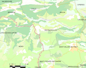
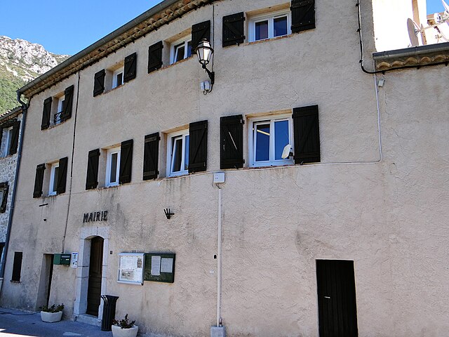
Эскраньоль
- коммуна в департаменте Приморские Альпы, регион Прованс — Альпы — Лазурный Берег, Франция
Hiking in Эскраньоль
Escragnolles is a charming village located in the Alpes-Maritimes department in the Provence-Alpes-Côte d'Azur region of southern France. It's a part of the stunning French Riviera's mountainous landscape, offering numerous hiking opportunities for outdoor enthusiasts....
- Страна:
- Почтовый код: 06460
- Координаты: 43° 43' 51" N, 6° 47' 0" E
- GPS треки (wikiloc): [Ссылка]
- Площадь: 25.48 кв.км
- Население: 614


Греольер
- коммуна в департаменте Приморские Альпы, регион Прованс — Альпы — Лазурный Берег, Франция
Hiking in Греольер
Gréolières is a charming village located in the Alpes-Maritimes region of France, in the foothills of the French Alps, and is known for its stunning landscapes and excellent hiking opportunities. Here are some details that could enhance your hiking experience in the area:...
- Страна:
- Почтовый код: 06620
- Координаты: 43° 47' 45" N, 6° 56' 37" E
- GPS треки (wikiloc): [Ссылка]
- Площадь: 52.67 кв.км
- Население: 606
- Веб сайт: [Ссылка]

Ле-Ма
- коммуна в департаменте Приморские Альпы, регион Прованс — Альпы — Лазурный Берег, Франция
Hiking in Ле-Ма
Le Mas, located in the beautiful region of Provence in southern France, offers a variety of hiking opportunities that showcase the area's stunning landscapes, charming villages, and rich cultural heritage. Here are some highlights and tips for hiking in Le Mas:...
- Страна:
- Почтовый код: 06910
- Координаты: 43° 50' 35" N, 6° 51' 30" E
- GPS треки (wikiloc): [Ссылка]
- Площадь: 32.15 кв.км
- Население: 158
- Веб сайт: [Ссылка]


Сен-Валье-де-Тье
- коммуна в департаменте Приморские Альпы, регион Прованс — Альпы — Лазурный Берег, Франция
Hiking in Сен-Валье-де-Тье
Saint-Vallier-de-Thiey is a charming village located in the Alpes-Maritimes department in southeastern France, offering a variety of hiking opportunities amidst beautiful landscapes. The region is characterized by its diverse terrain, which includes forested areas, rocky outcrops, and panoramic views of the surrounding mountains and valleys....
- Страна:
- Почтовый код: 06460
- Координаты: 43° 41' 56" N, 6° 50' 52" E
- GPS треки (wikiloc): [Ссылка]
- Площадь: 50.68 кв.км
- Население: 3526


Коссоль
- коммуна в департаменте Приморские Альпы, регион Прованс — Альпы — Лазурный Берег, Франция
Hiking in Коссоль
Caussols is a picturesque village located in the Alpes-Maritimes region of France, known for its stunning natural landscapes and diverse hiking opportunities. Nestled in the Provencal countryside and surrounded by beautiful forests, hills, and rocky outcrops, it offers a range of trails that cater to different skill levels....
- Страна:
- Почтовый код: 06460
- Координаты: 43° 44' 29" N, 6° 54' 0" E
- GPS треки (wikiloc): [Ссылка]
- Высота над уровнем моря: 1200 м m
- Площадь: 27.39 кв.км
- Население: 260
- Веб сайт: [Ссылка]