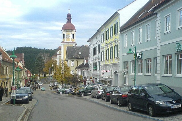
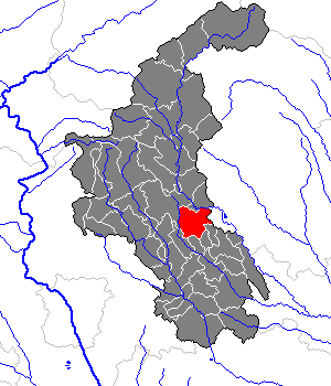
Ангер (Штирия) (Anger, Anger)

 Hiking in Ангер (Штирия)
Anger, located in Styria, Austria, is a charming town that serves as a great base for hiking enthusiasts looking to explore the stunning landscapes of the region. Styria is known for its beautiful hills, forests, and picturesque villages, making it a fantastic area for various hiking trails.
Hiking Highlights in and around Anger:
-
Scenic Trails: The trails around Anger typically offer a mix of moderate to challenging hikes. Many paths weave through lush forests, rolling hills, and scenic farmlands, providing beautiful views of the Styrian countryside.
-
Nearby Nature Reserves: Explore nearby natural attractions like the Buchberger Wald or the Zirbitzkogel–Grebenzen Nature Park, which offer a range of hiking trails, biodiversity, and breathtaking landscapes.
-
Family-Friendly Options: If you're hiking with family, look for gentle trails suitable for children. Many paths have educational signs about local flora and fauna, making hikes both enjoyable and informative.
-
Local Guides and Apps: Consider hiring a local guide who knows the trails well or using hiking apps that can provide maps and information on trail conditions.
-
Seasonal Variations: Depending on the season, the hiking experience can vary greatly. Spring and summer offer lush greenery and blooming wildflowers, while autumn presents vibrant fall colors. Winter hiking can also be a unique experience, but always check local conditions and ensure you're equipped for snow.
-
Cultural Aspects: Many trails may lead you through small villages where you can experience local culture, architecture, and perhaps stop for regional food specialties.
Tips for Hiking in Anger:
- Dress Appropriately: Weather can change quickly in the mountains, so dress in layers and be prepared for rain.
- Hydration and Snacks: Always carry enough water and snacks, especially if you’re planning a longer hike.
- Check Local Resources: Visit tourist information centers in Anger for maps, trail conditions, and recommendations.
- Respect Nature: Follow local guidelines to preserve the natural environment, including staying on marked trails and taking your litter with you.
Hiking in Anger, Styria, is a fantastic way to connect with nature, enjoy beautiful scenery, and experience the charm of the Austrian countryside. Happy hiking!
- Страна:

- Почтовый код: 8184
- Телефонный код: 03175
- Код автомобильного номера: WZ
- Координаты: 47° 16' 25" N, 15° 41' 24" E


- GPS треки (wikiloc): [Ссылка]
- Высота над уровнем моря: 479 м m
- Площадь: 1.97 кв.км
- Население: 4098
- Веб сайт: http://www.anger.st/
- Википедия русская: wiki(ru)
- Википедия английская: wiki(en)
- Википедия национальная: wiki(de)
- Хранилище Wikidata: Wikidata: Q537922
- Катеория в википедии: [Ссылка]
- код Freebase: [/m/03gwlk3]
- код GeoNames: Альт: [7872502]
- код GND: Альт: [10058112-2]
- идентификатор местоположения ArchINFORM: [10049]
- код места в Facebook: [102218393153696]
- код австрийского муниципалитета: [61756]
Граничит с регионами:


Таннхаузен
Hiking in Таннхаузен
Thannhausen, located in the Swabian region of Germany, offers a variety of hiking opportunities that are suitable for different skill levels. The area is characterized by scenic landscapes, rolling hills, and lush forests, making it a great destination for nature lovers....
- Страна:

- Почтовый код: 86470
- Телефонный код: 08281
- Код автомобильного номера: GZ
- Координаты: 48° 16' 0" N, 10° 28' 0" E
- GPS треки (wikiloc): [Ссылка]
- Высота над уровнем моря: 499 м m
- Площадь: 20.03 кв.км
- Население: 4825
- Веб сайт: [Ссылка]

Биркфельд
Hiking in Биркфельд
Birkfeld, located in Austria’s Styria region, is a charming destination for hiking enthusiasts. The area is surrounded by lush forests, rolling hills, and scenic landscapes, making it ideal for outdoor activities....
- Страна:
- Телефонный код: 03174
- Код автомобильного номера: WZ
- Координаты: 47° 21' 17" N, 15° 41' 42" E
- GPS треки (wikiloc): [Ссылка]
- Высота над уровнем моря: 639 м m
- Площадь: 4.26 кв.км
- Население: 4992
- Веб сайт: [Ссылка]


Санкт-Катрайн-ам-Оффенег
Hiking in Санкт-Катрайн-ам-Оффенег
Sankt Kathrein am Offenegg is a charming village located in the heart of Austria, particularly known for its beautiful natural landscapes and outdoor activities. Nestled in the Styrian region, it's an excellent destination for hiking enthusiasts....
- Страна:
- Почтовый код: 8171
- Телефонный код: 03179
- Код автомобильного номера: WZ
- Координаты: 47° 17' 58" N, 15° 34' 36" E
- GPS треки (wikiloc): [Ссылка]
- Высота над уровнем моря: 972 м m
- Площадь: 40.24 кв.км
- Население: 1086
- Веб сайт: [Ссылка]

Пёллау
Hiking in Пёллау
Pöllau is a picturesque spot located in the eastern part of Austria, particularly known for its charming landscapes, rolling hills, and lush greenery. Hiking in Pöllau offers an excellent opportunity to experience a mix of cultural and natural attractions. Here are some highlights and tips for hiking in the area:...
- Страна:
- Почтовый код: 8225
- Телефонный код: 03335
- Код автомобильного номера: HF
- Координаты: 47° 18' 7" N, 15° 50' 2" E
- GPS треки (wikiloc): [Ссылка]
- Высота над уровнем моря: 425 м m
- Площадь: 4.62 кв.км
- Население: 6054
- Веб сайт: [Ссылка]

Пух-Вайц
Hiking in Пух-Вайц
Puch bei Weiz is a beautiful area in Styria, Austria, that offers a variety of hiking opportunities amidst stunning natural scenery. The region is characterized by its rolling hills, lush forests, and picturesque landscapes, making it an ideal destination for outdoor enthusiasts....
- Страна:
- Почтовый код: 8182
- Телефонный код: 03177
- Код автомобильного номера: WZ
- Координаты: 47° 13' 27" N, 15° 43' 30" E
- GPS треки (wikiloc): [Ссылка]
- Высота над уровнем моря: 449 м m
- Площадь: 24.8 кв.км
- Население: 2091
- Веб сайт: [Ссылка]


Флойнг
Hiking in Флойнг
Floing is a picturesque area located in Styria, Austria, renowned for its stunning natural landscapes and various hiking opportunities. The region offers a blend of scenic trails, lush forests, and panoramic views of the surrounding mountains. Here are some highlights to consider if you're planning to hike in Floing:...
- Страна:
- Почтовый код: 8183
- Телефонный код: 03177
- Код автомобильного номера: WZ
- Координаты: 47° 15' 49" N, 15° 44' 48" E
- GPS треки (wikiloc): [Ссылка]
- Высота над уровнем моря: 639 м m
- Площадь: 13.17 кв.км
- Население: 1195
- Веб сайт: [Ссылка]