Ансуи (Ansouis, Ansouis)

- коммуна во Франции
 Hiking in Ансуи
Ansouis, a picturesque village in the Vaucluse department of the Provence-Alpes-Côte d'Azur region in France, offers a beautiful landscape perfect for hiking enthusiasts. Nestled in the Luberon Natural Regional Park, Ansouis is surrounded by vineyards, olive groves, and stunning hilltop views, making it a captivating destination for outdoor activities.
Hiking Trails
-
GR 97 Trail: This is part of the long-distance hiking network in France. The GR 97 runs through the Luberon Regional Park and offers breathtaking views of the countryside, charming villages, and diverse flora and fauna.
-
Local Hiking Paths: Ansouis features various marked trails that lead you through vineyards, forests, and hills. These paths vary in difficulty, making them suitable for both beginners and experienced hikers.
-
Montagne de Lure: Nearby, this mountain offers more challenging hikes with rewarding panoramas. The trails here are well-marked and take you through diverse landscapes.
Points of Interest
-
Château d'Ansouis: A beautiful historical castle that can be viewed from many hiking routes. It adds a touch of culture and history to your outdoor experience.
-
Vineyards and Olive Groves: Many trails pass through local vineyards, offering the chance to taste some of the region’s famous wines, as well as olive oils.
-
Panoramic Views: Higher trails provide stunning vistas of the Luberon valleys and beyond, making them perfect for photography and enjoying nature.
Best Times to Hike
- Spring (March to June): Ideal weather, with blooming wildflowers and comfortable temperatures.
- Fall (September to November): Enjoy the beautiful autumn colors, and the weather is still pleasant for hiking.
Tips for Hikers
- Footwear: Wear sturdy hiking boots to tackle varied terrains.
- Water and Snacks: Carry enough water and snacks, as some trails may not have amenities.
- Sun Protection: Don’t forget sunscreen and a hat, especially during warmer months.
- Map and Navigation: While many trails are marked, having a map or GPS can help you navigate more confidently.
Hiking in Ansouis not only offers a chance to explore the natural beauty of Provence but also to experience its rich culture and history. Whether you're looking for a leisurely stroll or a more intense hike, you'll find something to suit your preferences.
- Страна:

- Почтовый код: 84240
- Координаты: 43° 44' 16" N, 5° 27' 48" E


- GPS треки (wikiloc): [Ссылка]
- Площадь: 17.63 кв.км
- Население: 1051
- Веб сайт: http://www.ansouis.fr
- Википедия русская: wiki(ru)
- Википедия английская: wiki(en)
- Википедия национальная: wiki(fr)
- Хранилище Wikidata: Wikidata: Q322270
- Катеория в википедии: [Ссылка]
- код Freebase: [/m/0c39p6]
- код GeoNames: Альт: [3037482]
- номер SIREN: [218400026]
- код BNF: [15277983b]
- код VIAF: Альт: [140885623]
- ID отношения в OpenStreetMap: [73869]
- код GND: Альт: [7551405-9]
- код LCNAF: Альт: [n96023375]
- код муниципалитета INSEE: 84002
Граничит с регионами:

Кадене
- коммуна во Франции
Hiking in Кадене
Cadenet, located in the Provence-Alpes-Côte d'Azur region of southeastern France, is a charming village that serves as a great starting point for hiking adventures in the surrounding Vaucluse and Luberon regions. Here are some noteworthy aspects of hiking in and around Cadenet:...
- Страна:
- Почтовый код: 84160
- Координаты: 43° 44' 6" N, 5° 22' 24" E
- GPS треки (wikiloc): [Ссылка]
- Высота над уровнем моря: 234 м m
- Площадь: 25.08 кв.км
- Население: 4154
- Веб сайт: [Ссылка]

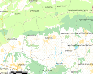
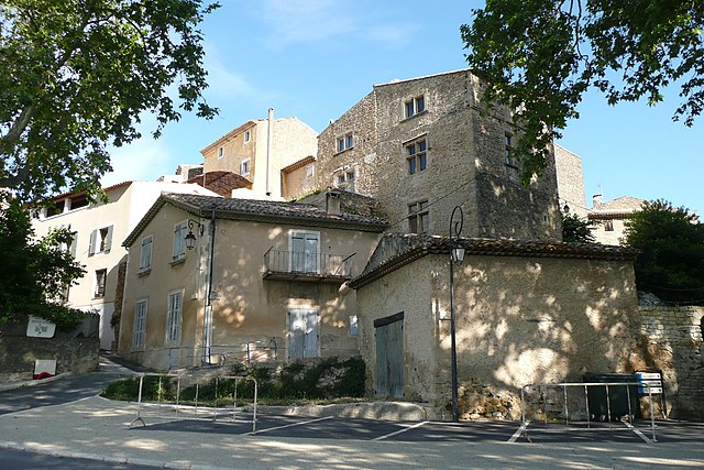
Кюкюрон
- коммуна во Франции
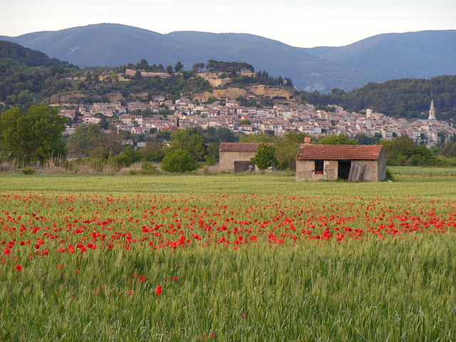
Hiking in Кюкюрон
Cucuron is a charming village located in the Provence region of southeastern France, known for its picturesque landscapes, historical architecture, and serene natural surroundings. While Cucuron itself may be small, it offers access to various hiking trails and scenic areas nearby. Here are some highlights and tips for hiking in and around Cucuron:...
- Страна:
- Почтовый код: 84160
- Координаты: 43° 46' 24" N, 5° 26' 19" E
- GPS треки (wikiloc): [Ссылка]
- Площадь: 32.68 кв.км
- Население: 1781
- Веб сайт: [Ссылка]


Пертюи
- коммуна во Франции
Hiking in Пертюи
Pertuis, located in the Vaucluse department of the Provence-Alpes-Côte d'Azur region in southeastern France, offers a variety of hiking opportunities that highlight the stunning landscapes and natural beauty of the area. Here are some features and trails you might find interesting:...
- Страна:
- Почтовый код: 84120
- Координаты: 43° 41' 39" N, 5° 30' 11" E
- GPS треки (wikiloc): [Ссылка]
- Площадь: 66.23 кв.км
- Население: 19645
- Веб сайт: [Ссылка]


Санн
Hiking in Санн
It seems like you might be referring to a specific location called "Sannes." However, I don't have specific information on a place by that name. If you meant a popular hiking destination, it could be a misspelling or a less-known location. Would you mind specifying if you're referring to a region, city, or a certain country?...
- Страна:
- Почтовый код: 84240
- Координаты: 43° 45' 26" N, 5° 29' 25" E
- GPS треки (wikiloc): [Ссылка]
- Площадь: 4.6 кв.км
- Население: 212
- Веб сайт: [Ссылка]


Вильлор
- коммуна во Франции
Hiking in Вильлор
Villelaure is a charming village located in the Provence-Alpes-Côte d'Azur region of southern France. It's surrounded by beautiful landscapes, making it a great destination for hiking enthusiasts. Here are some highlights of hiking in and around Villelaure:...
- Страна:
- Почтовый код: 84530
- Координаты: 43° 42' 38" N, 5° 26' 2" E
- GPS треки (wikiloc): [Ссылка]
- Площадь: 18.25 кв.км
- Население: 3361
- Веб сайт: [Ссылка]
Вожин
- коммуна во Франции
Hiking in Вожин
Vaugines is a charming village located in the Vaucluse department of the Provence-Alpes-Côte d'Azur region in southeastern France. Surrounded by beautiful natural scenery, it offers a variety of hiking opportunities for outdoor enthusiasts....
- Страна:
- Почтовый код: 84160
- Координаты: 43° 46' 44" N, 5° 24' 54" E
- GPS треки (wikiloc): [Ссылка]
- Площадь: 15.55 кв.км
- Население: 566


Ла-Тур-д'Эг
- коммуна во Франции
Hiking in Ла-Тур-д'Эг
La Tour-d'Aigues is a picturesque village located in the Vaucluse department of the Provence-Alpes-Côte d'Azur region in southern France. It's set in a lovely landscape of vineyards, hills, and charming countryside that provides ample opportunities for hiking and outdoor activities....
- Страна:
- Почтовый код: 84240
- Координаты: 43° 43' 31" N, 5° 32' 52" E
- GPS треки (wikiloc): [Ссылка]
- Площадь: 41.3 кв.км
- Население: 4196