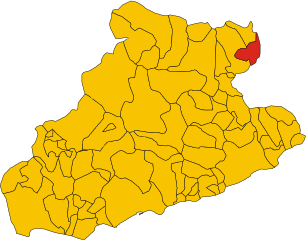
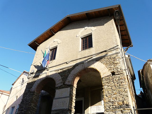
Акуила-д'Аррошия (Aquila d'Arroscia, Aquila d'Arroscia)
.svg)
- коммуна Италии
 Hiking in Акуила-д'Аррошия
Aquila d'Arroscia is a charming village located in the Liguria region of Italy, nestled in the picturesque hills of the Italian Riviera. The area offers opportunities for delightful hiking, surrounded by stunning landscapes, rich vegetation, and historical sites.
Hiking Trails
-
Pista della Salute: This is a popular trail that winds through forests and offers views of the surrounding mountains. It’s a relatively easy hike, making it suitable for families and beginners.
-
Ecovia della Valle Arroscia: This long-distance trail follows the Arroscia River and is part of a network of pathways that connect various villages in the region. It provides a mix of natural beauty and cultural heritage.
-
Monte Armetta: For those looking for a challenge, hiking to Monte Armetta offers a rewarding experience with panoramic views over the Ligurian landscape. The trail is more demanding, with steep sections that will appeal to experienced hikers.
What to Expect
- Scenery: Expect breathtaking views of the surrounding hills and valleys, especially in the spring when wildflowers bloom and the landscape is lush.
- Wildlife: The area is home to diverse flora and fauna, so keep an eye out for local wildlife, including various bird species.
- Historical Sites: Along the trails, you may find remnants of ancient settlements and churches, giving insight into the region's rich history.
Tips for Hiking in Aquila d'Arroscia
- Pack Accordingly: Bring sufficient water, snacks, and a first aid kit. Wear sturdy hiking shoes and bring layers, as weather can change quickly in the mountains.
- Check Local Maps: Before heading out, consult local maps or visitor centers for trail conditions and recommendations.
- Respect Nature: Follow Leave No Trace principles to help preserve the beauty of the area for future hikers.
Hiking in Aquila d'Arroscia can be a refreshing escape into nature, with a mix of physical activity and cultural exploration. Whether you're a casual hiker or an experienced backpacker, this area has something to offer everyone. Enjoy your hike!
- Страна:

- Почтовый код: 18020
- Телефонный код: 0183
- Код автомобильного номера: IM
- Координаты: 44° 5' 1" N, 8° 0' 20" E


- GPS треки (wikiloc): [Ссылка]
- Высота над уровнем моря: 680 м m
- Площадь: 10.06 кв.км
- Население: 158
- Веб сайт: http://aquilacomune.it/
- Википедия русская: wiki(ru)
- Википедия английская: wiki(en)
- Википедия национальная: wiki(it)
- Хранилище Wikidata: Wikidata: Q268098
- Катеория в википедии: [Ссылка]
- код Freebase: [/m/0gby56]
- код GeoNames: Альт: [6542427]
- ID отношения в OpenStreetMap: [42858]
- код ISTAT: 008003
- кадастровый код Италии: A344
Граничит с регионами:

Альто
- коммуна Италии
Hiking in Альто
Alto, located in the Piedmont region of Italy, offers a breathtaking landscape ideal for hiking enthusiasts. The area is characterized by its rolling hills, lush valleys, and the stunning backdrop of the Alps to the north. Here are some highlights and tips for hiking in Alto, Piedmont:...
- Страна:
- Почтовый код: 12070
- Телефонный код: 0174
- Код автомобильного номера: CN
- Координаты: 44° 7' 0" N, 8° 0' 0" E
- GPS треки (wikiloc): [Ссылка]
- Высота над уровнем моря: 650 м m
- Площадь: 7.46 кв.км
- Население: 130
- Веб сайт: [Ссылка]

Капрауна
- коммуна Италии
Hiking in Капрауна
Caprauna is a charming destination for hiking enthusiasts situated in the Italian region of Liguria, specifically in the province of Savona. This area is known for its stunning natural beauty, featuring lush greenery, mountainous terrains, and panoramic views of the surrounding landscape. Here’s an overview of hiking in Caprauna:...
- Страна:
- Почтовый код: 12070
- Телефонный код: 0174
- Код автомобильного номера: CN
- Координаты: 44° 7' 0" N, 7° 57' 0" E
- GPS треки (wikiloc): [Ссылка]
- Высота над уровнем моря: 1000 м m
- Площадь: 11.5 кв.км
- Население: 104
- Веб сайт: [Ссылка]


Боргетто-д'Аррошия
- коммуна Италии
Hiking in Боргетто-д'Аррошия
Borghetto d'Arroscia is a picturesque village located in the Liguria region of Italy, nestled in the Arroscia Valley. This area is known for its stunning natural landscapes, rich history, and a variety of hiking trails that cater to different skill levels. Here are some highlights about hiking in and around Borghetto d'Arroscia:...
- Страна:
- Почтовый код: 18020
- Телефонный код: 0183
- Код автомобильного номера: IM
- Координаты: 44° 3' 27" N, 7° 58' 54" E
- GPS треки (wikiloc): [Ссылка]
- Высота над уровнем моря: 155 м m
- Площадь: 25.94 кв.км
- Население: 449
- Веб сайт: [Ссылка]

Ранцо
- коммуна Италии
Hiking in Ранцо
Ranzo is a charming village located in the province of Savona, in the Liguria region of Italy. It offers a range of hiking opportunities that highlight the natural beauty of the surrounding landscape, including picturesque views of the Italian Riviera and the nearby Apennine mountains....
- Страна:
- Почтовый код: 18020
- Телефонный код: 0183
- Код автомобильного номера: IM
- Координаты: 44° 3' 34" N, 8° 0' 53" E
- GPS треки (wikiloc): [Ссылка]
- Высота над уровнем моря: 124 м m
- Площадь: 10.86 кв.км
- Население: 555
- Веб сайт: [Ссылка]


Назино
- коммуна Италии
Hiking in Назино
Nasino, a municipality located in the province of Imperia in the Italian region of Liguria, offers a fantastic array of hiking opportunities, particularly due to its proximity to the Ligurian Alps and the coastline. The area is characterized by its beautiful landscapes, diverse flora and fauna, quaint villages, and scenic views of the Mediterranean Sea....
- Страна:
- Почтовый код: 17030
- Телефонный код: 0182
- Код автомобильного номера: SV
- Координаты: 44° 6' 52" N, 8° 1' 47" E
- GPS треки (wikiloc): [Ссылка]
- Высота над уровнем моря: 335 м m
- Площадь: 22.18 кв.км
- Население: 193
- Веб сайт: [Ссылка]

Онцо
- коммуна Италии
Hiking in Онцо
Onzo, a small town located in the province of Imperia in the Liguria region of Italy, offers beautiful hiking opportunities amidst picturesque landscapes, charming villages, and scenic coastal views. Here’s what you can expect when hiking in and around Onzo:...
- Страна:
- Почтовый код: 17030
- Телефонный код: 0182
- Код автомобильного номера: SV
- Координаты: 44° 4' 12" N, 8° 3' 18" E
- GPS треки (wikiloc): [Ссылка]
- Высота над уровнем моря: 400 м m
- Площадь: 8.23 кв.км
- Население: 216
- Веб сайт: [Ссылка]