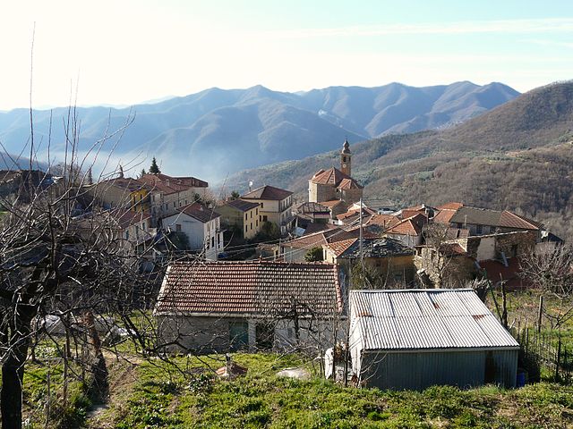
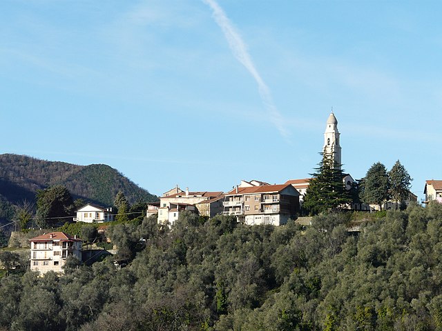
Ранцо (Ranzo, Ranzo)
.svg)
- коммуна Италии
 Hiking in Ранцо
Ranzo is a charming village located in the province of Savona, in the Liguria region of Italy. It offers a range of hiking opportunities that highlight the natural beauty of the surrounding landscape, including picturesque views of the Italian Riviera and the nearby Apennine mountains.
Hiking Trails in Ranzo
-
Sentiero della Valle Argentina: This trail runs through the Argentinal Valley, offering breathtaking views of the mountains and valleys. The trail showcases the local flora and fauna, making it a great option for nature enthusiasts.
-
Monte Galero: This hike leads to the peak of Monte Galero, which provides stunning panoramic views of the surrounding hills and the sea. The ascent is moderately challenging, making it suitable for hikers with some experience.
-
Via Alta dei Monti Liguri: A segment of this long-distance trail can be accessed from Ranzo. It winds through the Ligurian mountains and is well-marked. The trail is perfect for those looking for a more extended hike with varying levels of difficulty.
Best Time to Hike
The best time to hike in Ranzo is during the spring (April to June) and fall (September to October). During these seasons, the weather is generally mild, and the natural scenery is breathtaking, with wildflowers blooming in spring and vibrant autumn foliage.
Preparation and Safety
- Trail Maps: It's advisable to carry a map or use a hiking app to stay oriented, as some trails may not be well-marked.
- Gear: Wear sturdy hiking shoes and bring adequate water, snacks, and sun protection.
- Weather Check: Always check the local weather forecast before heading out, as conditions can change quickly in the mountains.
Local Considerations
Before hitting the trails, it's also good to familiarize yourself with local regulations and guidelines to ensure a responsible and enjoyable hiking experience.
In summary, hiking in Ranzo offers a unique blend of scenic landscapes and cultural experiences, making it a great destination for outdoor enthusiasts looking to explore the beauty of the Italian countryside.
- Страна:

- Почтовый код: 18020
- Телефонный код: 0183
- Код автомобильного номера: IM
- Координаты: 44° 3' 34" N, 8° 0' 53" E


- GPS треки (wikiloc): [Ссылка]
- Высота над уровнем моря: 124 м m
- Площадь: 10.86 кв.км
- Население: 555
- Веб сайт: http://www.comune.ranzo.im.it/Default.aspx?pageid=page481
- Википедия русская: wiki(ru)
- Википедия английская: wiki(en)
- Википедия национальная: wiki(it)
- Хранилище Wikidata: Wikidata: Q269695
- Катеория в википедии: [Ссылка]
- код Freebase: [/m/0gbz1k]
- код GeoNames: Альт: [6542497]
- код VIAF: Альт: [239241787]
- ID отношения в OpenStreetMap: [42827]
- UN/LOCODE: [ITRZ2]
- код ISTAT: 008048
- кадастровый код Италии: H180
Граничит с регионами:

Акуила-д'Аррошия
- коммуна Италии
Hiking in Акуила-д'Аррошия
Aquila d'Arroscia is a charming village located in the Liguria region of Italy, nestled in the picturesque hills of the Italian Riviera. The area offers opportunities for delightful hiking, surrounded by stunning landscapes, rich vegetation, and historical sites....
- Страна:
- Почтовый код: 18020
- Телефонный код: 0183
- Код автомобильного номера: IM
- Координаты: 44° 5' 1" N, 8° 0' 20" E
- GPS треки (wikiloc): [Ссылка]
- Высота над уровнем моря: 680 м m
- Площадь: 10.06 кв.км
- Население: 158
- Веб сайт: [Ссылка]


Боргетто-д'Аррошия
- коммуна Италии
Hiking in Боргетто-д'Аррошия
Borghetto d'Arroscia is a picturesque village located in the Liguria region of Italy, nestled in the Arroscia Valley. This area is known for its stunning natural landscapes, rich history, and a variety of hiking trails that cater to different skill levels. Here are some highlights about hiking in and around Borghetto d'Arroscia:...
- Страна:
- Почтовый код: 18020
- Телефонный код: 0183
- Код автомобильного номера: IM
- Координаты: 44° 3' 27" N, 7° 58' 54" E
- GPS треки (wikiloc): [Ссылка]
- Высота над уровнем моря: 155 м m
- Площадь: 25.94 кв.км
- Население: 449
- Веб сайт: [Ссылка]

Казанова-Лерроне
- коммуна Италии
Hiking in Казанова-Лерроне
Casanova Lerrone is a picturesque village located in the Liguria region of Italy, nestled within the Italian Riviera. It offers a variety of hiking opportunities suitable for different skill levels, making it an excellent destination for outdoor enthusiasts....
- Страна:
- Почтовый код: 17033
- Телефонный код: 0182
- Код автомобильного номера: SV
- Координаты: 44° 1' 54" N, 8° 2' 54" E
- GPS треки (wikiloc): [Ссылка]
- Высота над уровнем моря: 256 м m
- Площадь: 24.23 кв.км
- Население: 739
- Веб сайт: [Ссылка]


Назино
- коммуна Италии
Hiking in Назино
Nasino, a municipality located in the province of Imperia in the Italian region of Liguria, offers a fantastic array of hiking opportunities, particularly due to its proximity to the Ligurian Alps and the coastline. The area is characterized by its beautiful landscapes, diverse flora and fauna, quaint villages, and scenic views of the Mediterranean Sea....
- Страна:
- Почтовый код: 17030
- Телефонный код: 0182
- Код автомобильного номера: SV
- Координаты: 44° 6' 52" N, 8° 1' 47" E
- GPS треки (wikiloc): [Ссылка]
- Высота над уровнем моря: 335 м m
- Площадь: 22.18 кв.км
- Население: 193
- Веб сайт: [Ссылка]

Онцо
- коммуна Италии
Hiking in Онцо
Onzo, a small town located in the province of Imperia in the Liguria region of Italy, offers beautiful hiking opportunities amidst picturesque landscapes, charming villages, and scenic coastal views. Here’s what you can expect when hiking in and around Onzo:...
- Страна:
- Почтовый код: 17030
- Телефонный код: 0182
- Код автомобильного номера: SV
- Координаты: 44° 4' 12" N, 8° 3' 18" E
- GPS треки (wikiloc): [Ссылка]
- Высота над уровнем моря: 400 м m
- Площадь: 8.23 кв.км
- Население: 216
- Веб сайт: [Ссылка]