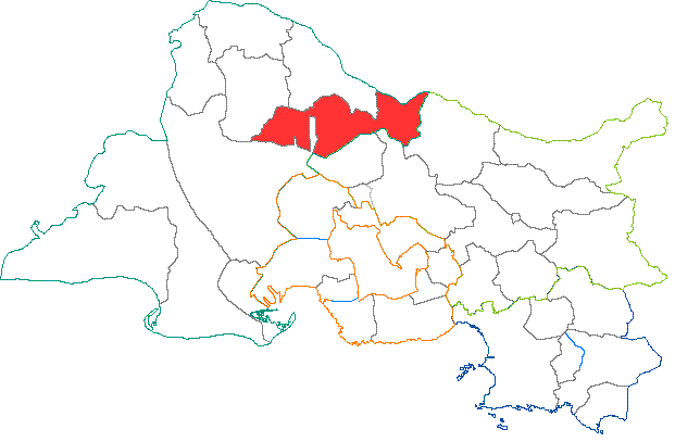
Арль (arrondissement of Arles, arrondissement d'Arles)

- округ Франции
 Hiking in Арль
The Arrondissement of Arles, located in the Bouches-du-Rhône department in the Provence-Alpes-Côte d'Azur region of southern France, offers a unique blend of natural beauty, historical significance, and diverse landscapes that make it an intriguing destination for hikers.
Key Hiking Areas:
-
Camargue Regional Nature Park:
- This vast natural park is known for its wetlands, marshes, and distinctive wildlife, including pink flamingos and wild horses. Hiking here allows you to explore a unique ecosystem and enjoy birdwatching, photography, and the scenery of the tranquil waterways.
- Popular trails often lead to viewpoints and along the "chemins de randonnée" where you can see the traditional working landscapes of the Camargue.
-
The Alpilles:
- A mountain range located just north of Arles, offering several trails that vary in difficulty and length. The trails wind through olive groves, vineyards, and limestone hills, providing stunning vistas of the surrounding valleys and countryside.
- The village of Les Baux-de-Provence is a great starting point for hikes in the Alpilles, where you can explore historical ruins alongside nature.
-
Historic Trails:
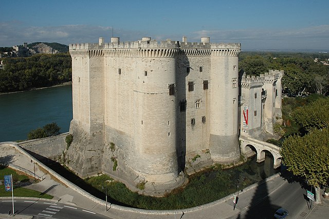
- The area around Arles is rich in history, with trails that lead you to ancient Roman ruins, including the Roman amphitheater and the theater of Arles, as well as via the Via Aurelia—an ancient Roman road.
- Many of these routes combine cultural visits with scenic walking, making them suitable for those interested in both history and nature.
Practical Hiking Tips:
- Preparation: Always check the weather and trail conditions before heading out. The Provence region can get hot in the summer, so it's advisable to hike in the early morning or late afternoon.
- Gear: Wear appropriate hiking boots and layers suitable for the weather. Always carry water, snacks, a map (or GPS), and a first-aid kit.
- Guided Tours: If you're unfamiliar with the area, consider joining a guided hike. Local guides can provide insights into the flora, fauna, and history of the landscape.
Best Hiking Season:
- Spring (March to May) and fall (September to November) are ideal for hiking in this region, as the temperatures are milder and the landscapes are vibrant with blooming flowers or autumn colors.
Conclusion:
Hiking in the Arrondissement of Arles offers a rich experience, with its stunning natural settings, wildlife, historical sites, and beautiful landscapes. Whether you’re a seasoned hiker or a casual walker, there’s something to explore for everyone.
- Страна:

- Столица: Арль
- Координаты: 43° 40' 0" N, 4° 45' 0" E


- GPS треки (wikiloc): [Ссылка]
- Площадь: 2284 кв.км
- Население: 207316
- Википедия русская: wiki(ru)
- Википедия английская: wiki(en)
- Википедия национальная: wiki(fr)
- Хранилище Wikidata: Wikidata: Q700484
- код Freebase: [/m/08cxy3]
- код GeoNames: Альт: [3036937]
- код округа INSEE: [132]
- код GNS: -1408371
Включает регионы:


Шаторенар (кантон)
- Страна:
- Столица: Шаторенар
- Координаты: 43° 53' 0" N, 4° 51' 19" E
- GPS треки (wikiloc): [Ссылка]
- Население: 72517

Эйгьер (кантон)
Hiking in Эйгьер (кантон)
Canton d'Eyguières is a beautiful region situated in the Bouches-du-Rhône department in the south of France. It offers a diverse range of landscapes and hiking opportunities, particularly appreciated for its stunning natural scenery, picturesque villages, and rich cultural heritage....


Пор-Сен-Луи-дю-Рон (кантон)
- Страна:
- Столица: Пор-Сен-Луи-дю-Рон
- Координаты: 43° 23' 15" N, 4° 48' 16" E
- GPS треки (wikiloc): [Ссылка]


Сен-Реми-де-Прованс
- кантон Франции
- Страна:
- Столица: Сен-Реми-де-Прованс
- Координаты: 43° 47' 24" N, 4° 49' 57" E
- GPS треки (wikiloc): [Ссылка]

Сент-Мари-де-ла-Мер
- Страна:
- Столица: Сент-Мари-де-ла-Мер
- Координаты: 43° 27' 10" N, 4° 25' 43" E
- GPS треки (wikiloc): [Ссылка]