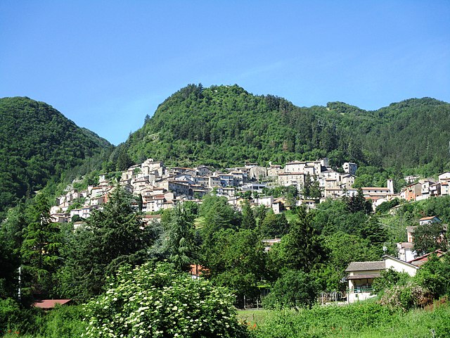
Арсоли (Arsoli, Arsoli)
.svg)
- коммуна Италии
 Hiking in Арсоли
Arsoli is a charming village located in the province of Rome, Italy, and is surrounded by beautiful natural landscapes that offer fantastic hiking opportunities. Nestled in the Simbruini Mountains, the area is characterized by its rugged terrain, lush forests, and stunning views, making it an excellent destination for outdoor enthusiasts.
Hiking Trails in Arsoli
-
Monte Gennaro: This trail is popular among hikers looking for panoramic vistas. The hike to the summit offers breathtaking views of the surrounding valleys and hills. The trail can be moderately challenging but is well worth the effort.
-
Parco Regionale dei Monti Simbruini: This regional park encompasses a vast area of pristine natural beauty, with various trails suitable for different skill levels. You can find trails ranging from easy walks to more difficult ascents. The park is rich in flora and fauna and is a great spot for birdwatching.
-
Valle dell'Aniene: Another beautiful area for hiking, this valley offers serene paths along the river Aniene, with opportunities to explore the surrounding woodlands. It's a great option for a leisurely hike or a picnic by the water.
Tips for Hiking in Arsoli
-
Preparation: Always check the weather before heading out and dress in layers, as temperatures can change rapidly in the mountains. Sturdy hiking boots and a good backpack are essential.
-
Navigation: Make sure to have a map of the area or a GPS device, as some trails may not be well-marked. Local hiking clubs or guides can also provide valuable information and safety tips.
-
Water and Snacks: Bring plenty of water and some snacks to keep your energy up during your hike, especially if you plan to be out for several hours.
-
Respect Nature: Follow local guidelines for conservation, such as sticking to marked paths and not disturbing wildlife.
Hiking in Arsoli provides a perfect blend of adventure and relaxation, with stunning natural beauty and cultural heritage waiting to be discovered. Enjoy your outdoor exploration!
- Страна:

- Почтовый код: 00023
- Телефонный код: 0774
- Код автомобильного номера: RM
- Координаты: 42° 2' 26" N, 13° 1' 4" E


- GPS треки (wikiloc): [Ссылка]
- Высота над уровнем моря: 470 м m
- Площадь: 12.2 кв.км
- Население: 1534
- Веб сайт: http://www.comunediarsoli.rm.it
- Википедия русская: wiki(ru)
- Википедия английская: wiki(en)
- Википедия национальная: wiki(it)
- Хранилище Wikidata: Wikidata: Q241758
- Катеория в википедии: [Ссылка]
- код Freebase: [/m/08kg6q]
- код GeoNames: Альт: [6536939]
- код VIAF: Альт: [236100049]
- ID отношения в OpenStreetMap: [41718]
- код ISTAT: 058010
- кадастровый код Италии: A446
Граничит с регионами:


Червара-ди-Рома
- коммуна Италии
Hiking in Червара-ди-Рома
Cervara di Roma is a charming mountain village located in the Apennines, known for its stunning landscapes, rich history, and excellent hiking opportunities. Here are some highlights about hiking in and around Cervara di Roma:...
- Страна:
- Почтовый код: 00020
- Телефонный код: 0774
- Код автомобильного номера: RM
- Координаты: 41° 59' 17" N, 13° 4' 2" E
- GPS треки (wikiloc): [Ссылка]
- Высота над уровнем моря: 1053 м m
- Площадь: 31.75 кв.км
- Население: 438
- Веб сайт: [Ссылка]


Марано-Экуо
- коммуна Италии
Hiking in Марано-Экуо
Marano Equo is a charming village located in the Roman province of Lazio, Italy, nestled in the Aniene Valley and surrounded by the beautiful Sabine Mountains. Hiking around this area offers a mix of stunning natural landscapes, historical sites, and traditional Italian culture. Here are some highlights and tips for hiking in Marano Equo:...
- Страна:
- Почтовый код: 00020
- Телефонный код: 0774
- Код автомобильного номера: RM
- Координаты: 41° 59' 38" N, 13° 1' 0" E
- GPS треки (wikiloc): [Ссылка]
- Высота над уровнем моря: 450 м m
- Площадь: 7.65 кв.км
- Население: 783
- Веб сайт: [Ссылка]
Риофреддо
- коммуна Италии
Hiking in Риофреддо
Riofreddo is a picturesque village located in the province of Rome, Italy, surrounded by the stunning landscapes of the Apennine Mountains. It's a great destination for hiking enthusiasts, offering various trails that cater to different skill levels. Here are some highlights for hiking in the Riofreddo area:...
- Страна:
- Почтовый код: 00020
- Телефонный код: 0774
- Код автомобильного номера: ROMA
- Координаты: 42° 3' 32" N, 12° 59' 48" E
- GPS треки (wikiloc): [Ссылка]
- Высота над уровнем моря: 705 м m
- Площадь: 12.38 кв.км
- Население: 749
- Веб сайт: [Ссылка]


Ровьяно
- коммуна Италии
Hiking in Ровьяно
Roviano, located in the province of Rome, Italy, is a picturesque town surrounded by the Monti Lucretili regional park. This area offers various hiking opportunities for outdoor enthusiasts, with trails that showcase the natural beauty of the region, including lush forests, stunning views, and charming rural landscapes....
- Страна:
- Почтовый код: 00027
- Телефонный код: 0774
- Код автомобильного номера: ROMA
- Координаты: 42° 1' 33" N, 12° 59' 40" E
- GPS треки (wikiloc): [Ссылка]
- Высота над уровнем моря: 523 м m
- Площадь: 8.5 кв.км
- Население: 1341
- Веб сайт: [Ссылка]


Орикола
- коммуна Италии
Hiking in Орикола
Oricola is a charming town located in the province of L'Aquila, in the Abruzzo region of Italy. It is known for its stunning natural landscapes, making it an excellent destination for hiking enthusiasts. Here are some key points to consider when hiking in Oricola:...
- Страна:
- Почтовый код: 67063
- Телефонный код: 0863
- Код автомобильного номера: AQ
- Координаты: 42° 3' 1" N, 13° 2' 22" E
- GPS треки (wikiloc): [Ссылка]
- Высота над уровнем моря: 810 м m
- Площадь: 18.36 кв.км
- Население: 1251
- Веб сайт: [Ссылка]

Рокка-ди-Ботте
- коммуна Италии
Hiking in Рокка-ди-Ботте
Rocca di Botte is a charming mountain village located in the Abruzzo region of Italy, nestled in the scenic Apennine Mountains. The area is known for its stunning natural landscapes, rich biodiversity, and opportunities for outdoor activities, particularly hiking....
- Страна:
- Почтовый код: 67066
- Телефонный код: 0863
- Код автомобильного номера: AQ
- Координаты: 42° 1' 38" N, 13° 4' 7" E
- GPS треки (wikiloc): [Ссылка]
- Высота над уровнем моря: 750 м m
- Площадь: 31.1 кв.км
- Население: 842
- Веб сайт: [Ссылка]