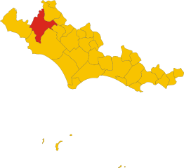
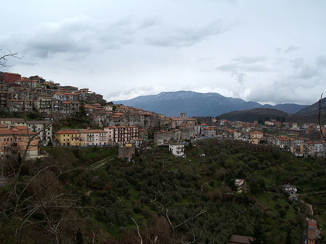
Артена (Artena, Artena)
.svg)
- коммуна Италии
 Hiking in Артена
Artena is a charming hilltop town located in the province of Rome, Italy. It is set in the beautiful landscape of the Lazio region, surrounded by hills, forests, and panoramic views, making it a great destination for hiking enthusiasts. Here are a few highlights about hiking in and around Artena:
Trails and Routes
-
Natural Reserves: The area around Artena features several nature reserves, such as the Castelli Romani Regional Park. These parks offer a variety of trails that cater to different skill levels, providing opportunities to hike through dense forests, along streams, and to scenic viewpoints.
-
Historical Trails: There are routes that connect Artena to other historic towns in the region, such as Palestrina and Colleferro. These hikes combine both nature and culture, allowing hikers to explore ancient ruins and learn about the area's history.
-
The Via Francigena: Parts of this ancient pilgrimage route pass near Artena. Hiking segments of the Via Francigena offers a unique glimpse into Italy's cultural heritage while enjoying the natural scenery.
Difficulty Levels
The hikes in this region range from easy, family-friendly walks to more challenging treks, suitable for experienced hikers. Always check the trail difficulty and prepare accordingly.
Best Time to Hike
The best time to hike in Artena is during the spring (March to June) and autumn (September to November) months when the weather is mild, and the landscapes are at their most vibrant. Summer can be hot, while winters can be cold with occasional snow in higher elevations.
What to Bring
- Proper Footwear: Sturdy hiking boots are essential for traction and comfort.
- Water and Snacks: Always carry enough water and some energy snacks.
- Map or GPS Device: While many trails are well-marked, having a map or GPS can help in case of detours.
- Weather Gear: Depending on the season, carry appropriate clothing for changing weather conditions.
Safety Tips
- Always let someone know your hiking plans.
- Stay on marked trails to prevent getting lost.
- Be mindful of wildlife and respect their habitats.
By exploring the hiking paths around Artena, you can enjoy stunning natural landscapes, rich history, and the tranquility of the Italian countryside. Happy hiking!
- Страна:

- Почтовый код: 00031
- Телефонный код: 06
- Код автомобильного номера: RM
- Координаты: 41° 44' 0" N, 12° 55' 0" E


- GPS треки (wikiloc): [Ссылка]
- Высота над уровнем моря: 420 м m
- Площадь: 54.8 кв.км
- Население: 14107
- Веб сайт: http://www.artena.comnet.roma.it
- Википедия русская: wiki(ru)
- Википедия английская: wiki(en)
- Википедия национальная: wiki(it)
- Хранилище Wikidata: Wikidata: Q241770
- Катеория в википедии: [Ссылка]
- код Freebase: [/m/089l49]
- код GeoNames: Альт: [6540515]
- код BNF: [15795751z]
- код VIAF: Альт: [150809679]
- ID отношения в OpenStreetMap: [41464]
- код GND: Альт: [4195209-1]
- код Цифрового атласа Римской империи: [21877]
- код ISTAT: 058011
- кадастровый код Италии: A449
Граничит с регионами:

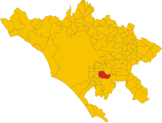
Чистерна-Ди-Латина
- коммуна Италии
Hiking in Чистерна-Ди-Латина
Cisterna di Latina, located in the Lazio region of Italy, offers a unique setting for hiking enthusiasts. This area is characterized by its picturesque landscapes, rolling hills, and proximity to both the Tyrrhenian Sea and the Apennine Mountains. If you're considering hiking in this area, here are some key points to consider:...
- Страна:
- Почтовый код: 04012
- Телефонный код: 06
- Код автомобильного номера: LT
- Координаты: 41° 36' 0" N, 12° 50' 0" E
- GPS треки (wikiloc): [Ссылка]
- Высота над уровнем моря: 77 м m
- Площадь: 144.16 кв.км
- Население: 36980
- Веб сайт: [Ссылка]


Кори
- коммуна Италии
Hiking in Кори
Cori, located in the region of Lazio, is known for its picturesque landscapes, rich history, and charming medieval architecture. Hiking in this area offers a blend of natural beauty and cultural exploration, making it a rewarding experience....
- Страна:
- Почтовый код: 04010
- Телефонный код: 06
- Код автомобильного номера: LT
- Координаты: 41° 39' 0" N, 12° 55' 0" E
- GPS треки (wikiloc): [Ссылка]
- Высота над уровнем моря: 384 м m
- Площадь: 85.31 кв.км
- Население: 10893
- Веб сайт: [Ссылка]
Рокка-Массима
- коммуна Италии
Hiking in Рокка-Массима
Rocca Massima is a small town located in the province of Latina, in the Lazio region of Italy. Nestled in the charming landscapes of the Lepini Mountains, it offers stunning views and a variety of hiking opportunities for both beginners and experienced hikers....
- Страна:
- Почтовый код: 04010
- Телефонный код: 06
- Код автомобильного номера: LT
- Координаты: 41° 41' 0" N, 12° 55' 0" E
- GPS треки (wikiloc): [Ссылка]
- Высота над уровнем моря: 735 м m
- Площадь: 18.17 кв.км
- Население: 1135
- Веб сайт: [Ссылка]


Веллетри
- коммуна Италии
Hiking in Веллетри
Velletri, a town located in the Castelli Romani region of Italy, offers a variety of hiking opportunities that showcase the natural beauty and historical significance of the area. Here are some key points about hiking in Velletri:...
- Страна:
- Почтовый код: 00049
- Телефонный код: 06
- Код автомобильного номера: ROMA
- Координаты: 41° 40' 0" N, 12° 47' 0" E
- GPS треки (wikiloc): [Ссылка]
- Высота над уровнем моря: 332 м m
- Площадь: 113.23 кв.км
- Население: 53188
- Веб сайт: [Ссылка]


Коллеферро
- коммуна Италии
Hiking in Коллеферро
Colleferro, located in the Lazio region of Italy, offers a variety of hiking opportunities thanks to its picturesque landscapes and proximity to the beautiful Monti Lepini mountain range. Here’s a breakdown of what you can expect when hiking in and around Colleferro:...
- Страна:
- Почтовый код: 00034
- Телефонный код: 06
- Код автомобильного номера: ROMA
- Координаты: 41° 43' 43" N, 13° 0' 11" E
- GPS треки (wikiloc): [Ссылка]
- Высота над уровнем моря: 218 м m
- Площадь: 27 кв.км
- Население: 21394
- Веб сайт: [Ссылка]
Лариано
- коммуна Италии
Hiking in Лариано
Lariano is a charming town located in the Lazio region of Italy, not far from Rome. It's surrounded by beautiful natural landscapes, making it an ideal destination for hiking enthusiasts. Here are some key points to consider if you're planning a hiking trip in Lariano:...
- Страна:
- Почтовый код: 00040
- Телефонный код: 06
- Код автомобильного номера: ROMA
- Координаты: 41° 44' 0" N, 12° 50' 0" E
- GPS треки (wikiloc): [Ссылка]
- Высота над уровнем моря: 350 м m
- Площадь: 22.53 кв.км
- Население: 13448
- Веб сайт: [Ссылка]


Палестрина
- коммуна Италии
Hiking in Палестрина
Palestrina, located just east of Rome, Italy, is not only rich in history but also offers various hiking opportunities that blend natural beauty with cultural exploration. Here are some aspects of hiking in Palestrina:...
- Страна:
- Почтовый код: 00036
- Телефонный код: 06
- Код автомобильного номера: ROMA
- Координаты: 41° 50' 0" N, 12° 54' 0" E
- GPS треки (wikiloc): [Ссылка]
- Высота над уровнем моря: 450 м m
- Площадь: 47.02 кв.км
- Население: 21872
- Веб сайт: [Ссылка]


Рокка-Приора
- коммуна Италии
Hiking in Рокка-Приора
Rocca Priora is a charming town located in the Alban Hills of Italy, approximately 30 kilometers southeast of Rome. It is part of the Regional Park of the Castelli Romani, which is known for its beautiful landscapes, rolling hills, and rich historical sites, making it a popular destination for hikers and nature enthusiasts....
- Страна:
- Почтовый код: 00040
- Телефонный код: 06
- Код автомобильного номера: RM
- Координаты: 41° 47' 0" N, 12° 46' 0" E
- GPS треки (wikiloc): [Ссылка]
- Высота над уровнем моря: 768 м m
- Площадь: 28.27 кв.км
- Население: 12060
- Веб сайт: [Ссылка]

Рокка-ди-Папа
- коммуна Италии
Hiking in Рокка-ди-Папа
Rocca di Papa is a beautiful town located in the Castelli Romani area of Italy, renowned for its stunning landscapes, historical sites, and excellent hiking opportunities. The town is situated on the slopes of the Alban Hills and provides access to several scenic trails that showcase the natural beauty of the region....
- Страна:
- Почтовый код: 00040
- Телефонный код: 06
- Код автомобильного номера: RM
- Координаты: 41° 46' 0" N, 12° 43' 0" E
- GPS треки (wikiloc): [Ссылка]
- Высота над уровнем моря: 680 м m
- Площадь: 39.72 кв.км
- Население: 17201
- Веб сайт: [Ссылка]

Сеньи
- коммуна Италии
Hiking in Сеньи
Segni, located in the province of Rome, Italy, offers a range of hiking opportunities with its beautiful landscapes, historical sites, and varied terrain. Nestled in the foothills of the Lepini Mountains, this area is perfect for outdoor enthusiasts looking to explore nature while appreciating the rich cultural heritage of the region....
- Страна:
- Почтовый код: 00037
- Телефонный код: 06
- Код автомобильного номера: RM
- Координаты: 41° 41' 0" N, 13° 1' 0" E
- GPS треки (wikiloc): [Ссылка]
- Высота над уровнем моря: 668 м m
- Площадь: 60.86 кв.км
- Население: 9192
- Веб сайт: [Ссылка]

Вальмонтоне
- коммуна Италии
Hiking in Вальмонтоне
Valmontone, located in the Lazio region of Italy, is not only known for its historical sites and proximity to the Rainbow Magicland amusement park but also offers some inviting hiking opportunities. Here are some aspects to consider if you're planning to hike in and around Valmontone:...
- Страна:
- Почтовый код: 00038
- Телефонный код: 06
- Код автомобильного номера: ROMA
- Координаты: 41° 46' 24" N, 12° 55' 7" E
- GPS треки (wikiloc): [Ссылка]
- Высота над уровнем моря: 303 м m
- Площадь: 40.91 кв.км
- Население: 16073
- Веб сайт: [Ссылка]