Атина (Atina, Lazio, Atina)
.svg)
- коммуна Италии
 Hiking in Атина
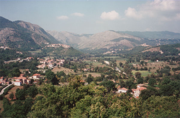
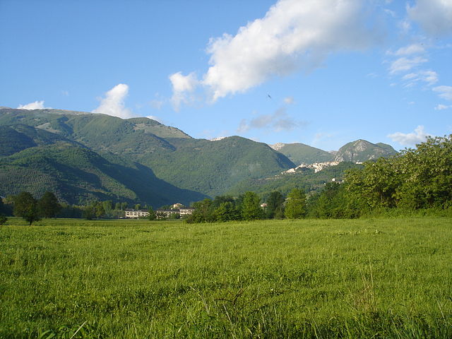
Atina, located in the province of Frosinone in the Lazio region of Italy, is a beautiful area known for its stunning landscapes and opportunities for hiking. Nestled in the hills of the Valle di Comino, Atina offers a mix of verdant valleys, rustic villages, and picturesque mountain views, making it an appealing destination for outdoor enthusiasts.
Hiking Trails and Routes
-
Sentiero del Parco Nazionale d'Abruzzo: While not directly within Atina, this nearby national park has several trails that can be accessed from the surrounding areas. The park boasts diverse flora and fauna and offers various levels of hiking difficulty, from easy walks to challenging treks.
-
Monte Meta: A prominent peak nearby, Monte Meta has trails that lead to panoramic views of the surrounding valleys and mountains. The trail can be demanding but is rewarding for those who tackle it.
-
Valle di Comino: Exploring the valleys and hills surrounding Atina provides a chance to hike through serene landscapes dotted with small villages and agricultural fields. The area is suitable for various hiking experiences, from leisurely walks to more strenuous hikes.
-
Historic Trails: Some trails in the area connect Atina with neighboring towns and villages, allowing hikers to explore the rich cultural heritage and history of the region. These routes often pass ancient ruins, churches, and old stone paths.
Best Time to Hike
The best times for hiking in Atina are during spring (April to June) and fall (September to October) when temperatures are milder and the scenery is particularly beautiful with blooming flowers or autumn foliage. Summer can be hot, so early morning or late afternoon hikes are recommended during those months.
Preparation Tips
- Footwear: Wear sturdy hiking shoes with good traction, as some trails may be steep or rocky.
- Water: Carry enough water to stay hydrated, especially during warmer months.
- Snack: Pack energy-boosting snacks like nuts, fruit, or granola bars.
- Navigation: While some trails are marked, it's wise to have a map or a GPS device if you're exploring lesser-known paths.
- Weather: Check the weather forecast before setting out and dress in layers to accommodate changing conditions.
Local Attractions
In addition to hiking, you can enjoy the local culture in Atina, such as tasting the regional cuisine, visiting historical sites, and exploring charming streets. Don’t miss the chance to try the local wines and other specialties.
Overall, hiking in and around Atina offers a mix of natural beauty, challenging trails, and cultural experiences, making it an excellent destination for outdoor lovers visiting Italy.
- Страна:

- Почтовый код: 03042
- Телефонный код: 0776
- Код автомобильного номера: FR
- Координаты: 41° 37' 0" N, 13° 48' 0" E


- GPS треки (wikiloc): [Ссылка]
- Высота над уровнем моря: 481 м m
- Площадь: 29.89 кв.км
- Население: 4245
- Веб сайт: http://www.comune.atina.fr.it
- Википедия русская: wiki(ru)
- Википедия английская: wiki(en)
- Википедия национальная: wiki(it)
- Хранилище Wikidata: Wikidata: Q116531
- Катеория в википедии: [Ссылка]
- код Freebase: [/m/0dr2_v]
- код GeoNames: Альт: [6538702]
- код VIAF: Альт: [132685673]
- ID отношения в OpenStreetMap: [41404]
- UN/LOCODE: [ITZCY]
- код Цифрового атласа Римской империи: [22561]
- код ISTAT: 060011
- кадастровый код Италии: A486
Граничит с регионами:
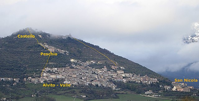

Альвито
- коммуна Италии
Hiking in Альвито
Alvito, located in the province of Frosinone in the Lazio region of Italy, is surrounded by beautiful natural landscapes, including the Abruzzo, Lazio, and Molise National Park. Hiking in this area offers a wonderful experience of both stunning scenery and cultural heritage....
- Страна:
- Почтовый код: 03041
- Телефонный код: 0776
- Код автомобильного номера: FR
- Координаты: 41° 41' 24" N, 13° 44' 53" E
- GPS треки (wikiloc): [Ссылка]
- Высота над уровнем моря: 475 м m
- Площадь: 51.72 кв.км
- Население: 2650
- Веб сайт: [Ссылка]
Бельмонте-Кастелло
- коммуна Италии
Hiking in Бельмонте-Кастелло
Belmonte Castello is a charming municipality in Italy, situated within the province of Frosinone in the Lazio region. It offers a variety of hiking opportunities thanks to its picturesque landscapes, hilly terrain, and rich historical context....
- Страна:
- Почтовый код: 03040
- Телефонный код: 0776
- Код автомобильного номера: FR
- Координаты: 41° 35' 0" N, 13° 49' 0" E
- GPS треки (wikiloc): [Ссылка]
- Высота над уровнем моря: 369 м m
- Площадь: 14.05 кв.км
- Население: 708
- Веб сайт: [Ссылка]

Казалаттико
- коммуна Италии
Hiking in Казалаттико
Casalattico is a charming town located in the Abruzzo region of Italy, surrounded by beautiful landscapes that offer excellent hiking opportunities. The area is characterized by its mountainous terrain, lush forests, and picturesque views, making it a great destination for outdoor enthusiasts....
- Страна:
- Почтовый код: 03030
- Телефонный код: 0776
- Код автомобильного номера: FR
- Координаты: 41° 37' 18" N, 13° 43' 30" E
- GPS треки (wikiloc): [Ссылка]
- Высота над уровнем моря: 420 м m
- Площадь: 28.38 кв.км
- Население: 549
- Веб сайт: [Ссылка]
Казалвиери
- коммуна Италии
Hiking in Казалвиери
Casalvieri, located in the province of Frosinone in the Lazio region of Italy, is surrounded by beautiful natural landscapes that are perfect for hiking enthusiasts. The area features lush hills, forests, and stunning views of the surrounding mountains, making it an attractive destination for both beginners and experienced hikers....
- Страна:
- Почтовый код: 03034
- Телефонный код: 0776
- Код автомобильного номера: FR
- Координаты: 41° 38' 0" N, 13° 43' 0" E
- GPS треки (wikiloc): [Ссылка]
- Высота над уровнем моря: 380 м m
- Площадь: 27.27 кв.км
- Население: 2665
- Веб сайт: [Ссылка]
Галлинаро
- коммуна Италии
Hiking in Галлинаро
Gallinaro is a small town located in the province of Frosinone, in the Lazio region of Italy. Nestled in the beautiful Apennine Mountains, this area offers stunning landscapes and a variety of hiking opportunities....
- Страна:
- Почтовый код: 03040
- Телефонный код: 0776
- Код автомобильного номера: FR
- Координаты: 41° 39' 18" N, 13° 47' 53" E
- GPS треки (wikiloc): [Ссылка]
- Высота над уровнем моря: 558 м m
- Площадь: 17.74 кв.км
- Население: 1232
- Веб сайт: [Ссылка]

Пичиниско
- коммуна Италии
Hiking in Пичиниско
Picinisco is a charming village located in the province of Frosinone, in the Lazio region of Italy. Nestled in the Apennine mountains, it offers a variety of hiking opportunities that allow visitors to explore its stunning natural landscapes, rich biodiversity, and historical sites....
- Страна:
- Почтовый код: 03040
- Телефонный код: 0776
- Код автомобильного номера: FR
- Координаты: 41° 39' 0" N, 13° 52' 0" E
- GPS треки (wikiloc): [Ссылка]
- Высота над уровнем моря: 725 м m
- Площадь: 62.15 кв.км
- Население: 1173
- Веб сайт: [Ссылка]
Терелле
- коммуна Италии
Hiking in Терелле
Terelle, a charming village located in the beautiful region of Lazio, Italy, is surrounded by stunning natural landscapes, making it an excellent destination for hiking enthusiasts. The area is characterized by rolling hills, lush forests, and breathtaking views, ideal for both novice and experienced hikers....
- Страна:
- Почтовый код: 03040
- Телефонный код: 0776
- Код автомобильного номера: FR
- Координаты: 41° 33' 0" N, 13° 47' 0" E
- GPS треки (wikiloc): [Ссылка]
- Высота над уровнем моря: 905 м m
- Площадь: 31.65 кв.км
- Население: 376
- Веб сайт: [Ссылка]
Вилла-Латина
- коммуна Италии
Hiking in Вилла-Латина
Villa Latina is a charming location in the Italian region of Lazio, known for its beautiful landscapes and outdoor activities, including hiking. Nestled in the Monti Aurunci National Park, the area offers a variety of trails that cater to different skill levels, making it an excellent destination for both novice and experienced hikers....
- Страна:
- Почтовый код: 03040
- Телефонный код: 0776
- Код автомобильного номера: FR
- Координаты: 41° 37' 0" N, 13° 50' 0" E
- GPS треки (wikiloc): [Ссылка]
- Высота над уровнем моря: 415 м m
- Площадь: 17.02 кв.км
- Население: 1217