Авансон (Avançon, Avançon)
- коммуна во Франции
 Hiking in Авансон
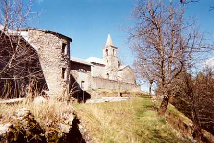
Avançon is a picturesque commune in the Hautes-Alpes department of southeastern France, located in the southern Alps. This region is known for its stunning landscapes, including mountains, valleys, and clear rivers, which make it an excellent destination for hiking enthusiasts.
Hiking Opportunities
-
Diverse Terrain: The Hautes-Alpes region offers a variety of hiking trails that accommodate all skill levels, from easy walks suitable for families to challenging ascents for experienced hikers. The terrain ranges from alpine meadows to steep mountain paths.
-
Scenic Views: Many trails provide breathtaking views of the surrounding peaks, including the Écrins National Park. Hikers can experience stunning panoramas of rugged mountains, clear lakes, and vibrant wildflowers during the summer months.
-
Local Trails: There are numerous marked trails in and around Avançon that lead to beautiful vistas, charming villages, and historical sites. The GR (long-distance hiking) trails, such as the GR 54, are particularly popular and traverse some of the most scenic areas.
-
Wildlife Watching: The region is rich in biodiversity, and hikers may encounter various wildlife species, including chamois, marmots, and a variety of bird species. Wildlife watching can be particularly rewarding, especially during the early morning or late evening.
Tips for Hiking in Avançon
- Preparation: Always check the weather conditions before heading out and make sure to dress in layers, as alpine weather can change quickly.
- Safety: Carry sufficient water, snacks, a map, and a compass, or use a GPS device. Inform someone about your hiking plan and expected return time.
- Footwear: Wear sturdy hiking boots to navigate rocky and uneven terrain comfortably.
- Leave No Trace: Follow the Leave No Trace principles to help preserve the natural beauty of the area. Stay on marked trails and dispose of waste properly.
Best Time to Hike
The ideal time for hiking in Avançon is during the late spring through early autumn (May to October), when the trails are more accessible, and the weather is typically warmer. Summer brings wildflower blooms and lush greenery, while autumn offers stunning foliage.
Whether you're looking for a leisurely hike or a more challenging adventure, Avançon and the surrounding Hautes-Alpes offer a spectacular backdrop for a memorable hiking experience.
- Страна:

- Почтовый код: 05230
- Координаты: 44° 31' 31" N, 6° 11' 7" E


- GPS треки (wikiloc): [Ссылка]
- Площадь: 22.57 кв.км
- Население: 402
- Википедия русская: wiki(ru)
- Википедия английская: wiki(en)
- Википедия национальная: wiki(fr)
- Хранилище Wikidata: Wikidata: Q1340871
- Катеория в википедии: [Ссылка]
- код Freebase: [/m/03m812r]
- код Freebase: [/m/03m812r]
- код GeoNames: Альт: [6446621]
- код GeoNames: Альт: [6446621]
- номер SIREN: [210500112]
- номер SIREN: [210500112]
- код тезауруса PACTOLS: [pcrtZatO39185c]
- код тезауруса PACTOLS: [pcrtZatO39185c]
- код муниципалитета INSEE: 05011
- код муниципалитета INSEE: 05011
Граничит с регионами:

Ла-Бати-Вьей
- коммуна во Франции
Hiking in Ла-Бати-Вьей
La Bâtie-Vieille, a small village located in the French Alps, offers beautiful hiking opportunities and stunning natural scenery. Here are some key points to consider if you're planning to hike in this region:...
- Страна:
- Почтовый код: 05000
- Координаты: 44° 33' 14" N, 6° 9' 45" E
- GPS треки (wikiloc): [Ссылка]
- Площадь: 9.05 кв.км
- Население: 346
- Веб сайт: [Ссылка]

Тею
- коммуна во Франции
Hiking in Тею
Théus, a small village in the Hautes-Alpes region of France, offers a variety of hiking opportunities amidst beautiful Alpine scenery. Here’s what you need to know if you're planning to hike in or around Théus:...
- Страна:
- Почтовый код: 05190
- Координаты: 44° 28' 34" N, 6° 11' 18" E
- GPS треки (wikiloc): [Ссылка]
- Площадь: 16.71 кв.км
- Население: 202

Сент-Этьен-ле-Ло
- коммуна во Франции
Hiking in Сент-Этьен-ле-Ло
Saint-Étienne-le-Laus is a charming village located in the Hautes-Alpes region of France, offering beautiful hiking opportunities amidst stunning natural landscapes. The area is characterized by picturesque mountains, lush valleys, and diverse flora and fauna, making it a great destination for outdoor enthusiasts....
- Страна:
- Почтовый код: 05130
- Координаты: 44° 30' 8" N, 6° 9' 44" E
- GPS треки (wikiloc): [Ссылка]
- Площадь: 8.66 кв.км
- Население: 294
Монгарден
- коммуна во Франции
Hiking in Монгарден
Montgardin, located in the Hautes-Alpes region of France, offers beautiful hiking opportunities in the heart of the French Alps. The area is known for its stunning alpine landscapes, including mountains, valleys, and picturesque villages. Here are some highlights to consider when planning a hike in Montgardin:...
- Страна:
- Почтовый код: 05230
- Координаты: 44° 33' 1" N, 6° 14' 23" E
- GPS треки (wikiloc): [Ссылка]
- Площадь: 15.32 кв.км
- Население: 462
- Веб сайт: [Ссылка]

Эспинас
- коммуна в департаменте Верхние Альпы, Франция
Hiking in Эспинас
Espinasses is a charming village located in the French Alps, in the department of Hautes-Alpes. It offers a variety of hiking opportunities suitable for different skill levels, surrounded by stunning natural beauty....
- Страна:
- Почтовый код: 05190
- Координаты: 44° 28' 0" N, 6° 13' 29" E
- GPS треки (wikiloc): [Ссылка]
- Площадь: 13.86 кв.км
- Население: 728
- Веб сайт: [Ссылка]

Ла-Бати-Нёв
- коммуна во Франции
Hiking in Ла-Бати-Нёв
La Bâtie-Neuve is a picturesque village located in the Hautes-Alpes region of southeastern France. It's an excellent destination for hiking enthusiasts due to its stunning natural surroundings, including the nearby Écrins National Park and the breathtaking landscapes of the Alps....
- Страна:
- Почтовый код: 05230
- Координаты: 44° 34' 0" N, 6° 11' 45" E
- GPS треки (wikiloc): [Ссылка]
- Площадь: 27.99 кв.км
- Население: 2487
- Веб сайт: [Ссылка]