Avignon-lès-Saint-Claude (Avignon-lès-Saint-Claude)

- коммуна во Франции
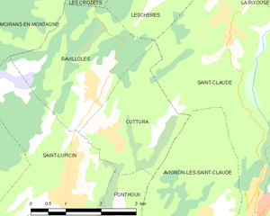
 Hiking in Avignon-lès-Saint-Claude
Avignon-lès-Saint-Claude, located in the Jura Mountains of France, offers a beautiful setting for hiking enthusiasts. The region is characterized by its stunning natural landscapes, including forests, rolling hills, and panoramic views of the surrounding mountains.
Hiking in Avignon-lès-Saint-Claude
-
Trails and Routes:
- There are several well-marked hiking trails around Avignon-lès-Saint-Claude, varying in difficulty and length. Popular routes include easier family-friendly paths as well as more challenging hikes for experienced trekkers.
- The GR (Grande Randonnée) 9 trail passes nearby, offering a longer hiking option that connects various regions of the Jura.
-
Scenic Views:
- Hikers can enjoy breathtaking views of the Jura Mountains, particularly from higher elevations. Lookouts along some trails provide great spots for photos and resting.
-
Natural Attractions:
- The area is rich in biodiversity, with different flora and fauna to observe. You may encounter numerous wildflowers, birds, and possibly even deer along the trails.
- Nearby natural sites, such as waterfalls and lakes, can often be incorporated into hiking itineraries.
-
Best Time to Hike:
- Spring and fall are particularly beautiful times for hiking in this region, with mild temperatures and vibrant foliage. Summer can be warm, while winter months may have snow, suitable for winter hiking or snowshoeing.
-
Preparation:
- Be sure to wear appropriate footwear and bring sufficient water and snacks. A good hiking map or GPS device is recommended, as some trails may not have consistent signage.
-
Local Amenities:
- The village offers basic amenities, including small shops and possibly local accommodations. It’s advisable to check for local guides or organized hikes if you prefer structured experiences.
Hiking in Avignon-lès-Saint-Claude is not only a way to enjoy nature but also to experience the charm of the Jura region. Whether you're a seasoned hiker or a beginner, there are many options to explore and enjoy the landscape.
- Страна:

- Почтовый код: 39200
- Координаты: 46° 23' 26" N, 5° 50' 47" E


- GPS треки (wikiloc): [Ссылка]
- Высота над уровнем моря: 729 м m
- Площадь: 7.83 кв.км
- Население: 390
- Википедия английская: wiki(en)
- Википедия национальная: wiki(fr)
- Хранилище Wikidata: Wikidata: Q790977
- Катеория в википедии: [Ссылка]
- код Freebase: [/m/08x5x0]
- код GeoNames: Альт: [6616689]
- номер SIREN: [213900327]
- код BNF: [15258398j]
- код муниципалитета INSEE: 39032
Граничит с регионами:


Сен-Клод
- коммуна во Франции
Hiking in Сен-Клод
Saint-Claude, located in the Jura region of France, is a fantastic destination for hiking enthusiasts. Nestled in the mountains, it offers a variety of trails that cater to different skill levels, from leisurely walks to challenging treks. Here are some highlights about hiking in Saint-Claude:...
- Страна:
- Почтовый код: 39200
- Координаты: 46° 23' 14" N, 5° 51' 48" E
- GPS треки (wikiloc): [Ссылка]
- Площадь: 70.19 кв.км
- Население: 9732
- Веб сайт: [Ссылка]


Ponthoux
- коммуна во Франции
Hiking in Ponthoux
Ponthoux is a charming village located in the Alpes-Maritimes region of France, near the French Riviera. The surrounding area offers beautiful landscapes, featuring a mix of forests, hills, and views of the Mediterranean. Here are some key points to consider when hiking in and around Ponthoux:...
- Страна:
- Почтовый код: 39170
- Координаты: 46° 23' 45" N, 5° 48' 39" E
- GPS треки (wikiloc): [Ссылка]
- Высота над уровнем моря: 300 м m
- Площадь: 2.18 кв.км
- Население: 75

Cuttura
- коммуна во Франции
Hiking in Cuttura
Cuttura, a lesser-known but beautiful area, offers scenic landscapes that are ideal for hiking enthusiasts. While my specific information on Cuttura may be limited, here are some general hiking tips and things to consider when exploring the area:...
- Страна:
- Почтовый код: 39170
- Координаты: 46° 24' 48" N, 5° 48' 41" E
- GPS треки (wikiloc): [Ссылка]
- Площадь: 5.95 кв.км
- Население: 326