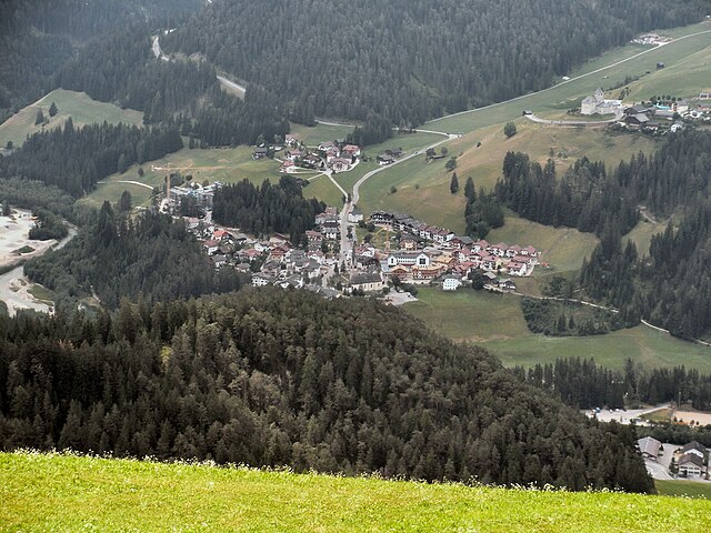
Бадия (Badia, Badia)
.svg)
- коммуна Италии
 Hiking in Бадия
Hiking in Badia, located in the heart of South Tyrol, Italy, offers a unique blend of stunning natural landscapes, rich cultural heritage, and a variety of trails suitable for all skill levels. Here are several important aspects of hiking in this beautiful area:
Trails and Routes
-
Diverse Difficulty Levels: Badia provides numerous trails ranging from easy walks suitable for families to challenging mountain hikes. Popular routes include the Trail of the Three Peaks and paths leading to the scenic Prags Valley.
-
Duration and Scenery: Depending on your skill level, hikes can vary from short, 1-2 hour walks to more extended excursions that can last all day. Many trails offer breathtaking views of the Dolomites, alpine meadows, and charming villages.
-
Signposted Routes: Trails are well-marked with signs and maps available at visitor centers, ensuring that hikers can easily navigate the area.
Highlights
-
Sass de Putia: A prominent mountain that is a popular destination for hikers. The views from the summit are spectacular, and the landscape is often dotted with picturesque alpine flora.
-
Lago di Braies: While a bit of a drive from Badia, this stunning lake is often part of hiking itineraries in the region, providing excellent photo opportunities.
-
Cultural Sites: As you hike, you may encounter traditional Ladin villages, historic churches, and local farms, giving you a taste of the unique culture and history of the region.
Best Time to Hike
-
Spring (May – June): Mild weather and blooming wildflowers make for pleasant hiking conditions.
-
Summer (July – August): The most popular season, with warm temperatures and full access to trails. However, it can be crowded at times.
-
Autumn (September – October): Offers stunning fall foliage, cooler temperatures, and fewer crowds, making it ideal for a peaceful hike.
Preparation Tips
-
Gear: Good hiking boots, weather-appropriate clothing, trekking poles, and supplies such as water, snacks, and a map or GPS device are essential.
-
Weather: Conditions can change rapidly in the mountains, so monitoring the weather and being prepared for sudden changes is crucial.
-
Local Regulations: Be mindful of local rules regarding wildlife, trail usage, and camping, to help preserve the environment for everyone.
Additional Activities
In addition to hiking, Badia offers opportunities for mountain biking, climbing, and even skiing in the winter months, making it a year-round destination for outdoor enthusiasts.
Overall, hiking in Badia, South Tyrol, is an enriching experience that combines natural beauty, adventure, and cultural discovery. Whether you're an experienced hiker or just starting, this region has something to offer everyone!
- Страна:

- Почтовый код: 39036
- Телефонный код: 0471
- Код автомобильного номера: BZ
- Координаты: 46° 36' 40" N, 11° 53' 40" E


- GPS треки (wikiloc): [Ссылка]
- Высота над уровнем моря: 1315 м m
- Площадь: 83.18 кв.км
- Население: 3491
- Веб сайт: http://www.comunbadia.it
- Википедия русская: wiki(ru)
- Википедия английская: wiki(en)
- Википедия национальная: wiki(it)
- Хранилище Wikidata: Wikidata: Q333816
- Галерея изображений в википедии: [Ссылка]
- Катеория в википедии: [Ссылка]
- код Freebase: [/m/0ccbyq]
- код GeoNames: Альт: [6535967]
- код VIAF: Альт: [133144647636950357852]
- ID отношения в OpenStreetMap: [47255]
- код GND: Альт: [4264792-7]
- место в MusicBrainz: [da790244-e653-4f14-900f-d6e28eec93e0]
- код ISTAT: 021006
- кадастровый код Италии: A537
Граничит с регионами:


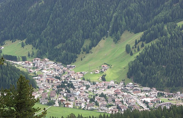
Корвара-ин-Бадия
- коммуна в регионе Трентино — Альто-Адидже, Италия
Hiking in Корвара-ин-Бадия
Corvara, located in the heart of the Dolomites in South Tyrol, Italy, is a stunning destination for hiking enthusiasts. Surrounded by dramatic mountain peaks, lush valleys, and picturesque meadows, it offers a wide variety of hiking experiences suitable for all skill levels. Here’s an overview of what you can expect when hiking in Corvara:...
- Страна:
- Почтовый код: 39033
- Телефонный код: 0471
- Код автомобильного номера: BZ
- Координаты: 46° 33' 1" N, 11° 52' 24" E
- GPS треки (wikiloc): [Ссылка]
- Высота над уровнем моря: 1568 м m
- Площадь: 38.92 кв.км
- Население: 1372
- Веб сайт: [Ссылка]


Ливиналлонго-дель-Коль-ди-Лана
- коммуна Италии
Hiking in Ливиналлонго-дель-Коль-ди-Лана
Livinallongo del Col di Lana is a stunning valley located in the Dolomites of northern Italy. It offers a unique combination of breathtaking landscapes, rich history, and a variety of hiking trails that cater to different skill levels....
- Страна:
- Почтовый код: 32020
- Телефонный код: 0436
- Код автомобильного номера: BL
- Координаты: 46° 29' 0" N, 11° 57' 0" E
- GPS треки (wikiloc): [Ссылка]
- Высота над уровнем моря: 1645 м m
- Площадь: 100.01 кв.км
- Население: 1300
- Веб сайт: [Ссылка]


Кортина-д’Ампеццо
- коммуна Италии
Hiking in Кортина-д’Ампеццо
Cortina d'Ampezzo, located in the Veneto region of Italy, is a renowned destination for hiking enthusiasts, offering stunning landscapes, diverse trails, and breathtaking views of the Dolomites, a UNESCO World Heritage site. Here’s a guide to hiking in this beautiful area:...
- Страна:
- Почтовый код: 32043
- Телефонный код: 0436
- Код автомобильного номера: BL
- Координаты: 46° 32' 17" N, 12° 8' 14" E
- GPS треки (wikiloc): [Ссылка]
- Высота над уровнем моря: 1224 м m
- Площадь: 252.81 кв.км
- Население: 5852
- Веб сайт: [Ссылка]


Ла-Валле
- коммуна Италии
Hiking in Ла-Валле
La Val, located in the Dolomites of Northern Italy, is a picturesque destination ideal for hiking enthusiasts. This charming valley is part of the South Tyrol province and is known for its stunning landscapes, rich culture, and a wide array of hiking trails suitable for all levels of experience....
- Страна:
- Почтовый код: 39030
- Телефонный код: 0471
- Код автомобильного номера: BZ
- Координаты: 46° 39' 27" N, 11° 55' 26" E
- GPS треки (wikiloc): [Ссылка]
- Высота над уровнем моря: 1353 м m
- Площадь: 38.92 кв.км
- Население: 1387
- Веб сайт: [Ссылка]


Мареббе
- коммуна Италии
Hiking in Мареббе
Mareo is a charming area in the Asturias region of northern Spain, known for its breathtaking natural landscapes, rich biodiversity, and traditional villages. Hiking in Mareo can be a rewarding experience, offering various trails that cater to hikers of different skill levels. Here are a few key points to consider if you plan on hiking in this area:...
- Страна:
- Почтовый код: 39030
- Телефонный код: 0474
- Код автомобильного номера: BZ
- Координаты: 46° 43' 8" N, 11° 55' 1" E
- GPS треки (wikiloc): [Ссылка]
- Высота над уровнем моря: 1186 м m
- Площадь: 160.32 кв.км
- Население: 3037
- Веб сайт: [Ссылка]

Сан-Мартино-ин-Бадия
- коммуна в Италии
Hiking in Сан-Мартино-ин-Бадия
San Martin de Tor, located in the Dolomites of Northern Italy, is an excellent destination for hiking enthusiasts. The area is known for its stunning landscapes, rich cultural heritage, and a variety of trails that cater to different skill levels. Here are some highlights and tips for hiking in and around San Martin de Tor:...
- Страна:
- Почтовый код: 39030
- Телефонный код: 0474
- Код автомобильного номера: BZ
- Координаты: 46° 40' 54" N, 11° 53' 53" E
- GPS треки (wikiloc): [Ссылка]
- Высота над уровнем моря: 1127 м m
- Площадь: 75.94 кв.км
- Население: 1744
- Веб сайт: [Ссылка]

Сельва-ди-Валь-Гардена
- коммуна в Италии
Hiking in Сельва-ди-Валь-Гардена
Sëlva, known as Selva di Val Gardena, is a picturesque village located in the Dolomites of northern Italy, particularly popular for its stunning landscapes and diverse hiking trails. The Dolomites are a UNESCO World Heritage site, making hiking in this region an unforgettable experience....
- Страна:
- Почтовый код: 39048
- Телефонный код: 0471
- Код автомобильного номера: BZ
- Координаты: 46° 33' 17" N, 11° 45' 37" E
- GPS треки (wikiloc): [Ссылка]
- Высота над уровнем моря: 1563 м m
- Площадь: 56.24 кв.км
- Население: 2621
- Веб сайт: [Ссылка]