
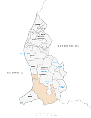
Бальцерс (Balzers, Balzers)


 Hiking in Бальцерс
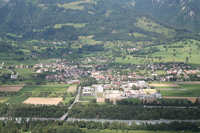
Balzers is a beautiful municipality in Liechtenstein, known for its scenic landscapes, historic sites, and outdoor activities, including hiking. Situated in the Rhine Valley, Balzers offers a range of hiking trails suitable for all skill levels, from leisurely walks to more challenging hikes.
Popular Hiking Trails in Balzers:
-
Burg Gutenberg: This hike leads you to the historic Gutenberg Castle, which offers stunning views of the valley and surrounding mountains. The trail is relatively easy and suitable for families. It's a perfect way to combine history with nature.
-
Liechtenstein Trail: This long-distance trail passes through Balzers and showcases the diverse landscapes of the country. The trail covers around 75 km in total, with sections that are more challenging but reward hikers with incredible vistas.
-
Hiking to the Rhine: A gentler trail that leads you along the banks of the Rhine River, providing a peaceful setting ideal for enjoying nature, birdwatching, or having a picnic.
-
Panoramaweg (Panorama Trail): This loop trail offers panoramic views of the surrounding mountains and meadows. It’s a moderate hike and is perfect for those wanting to immerse themselves in the natural beauty of the region.
Tips for Hiking in Balzers:
- Weather: Be sure to check the weather forecast before heading out, as conditions can change rapidly, especially in mountainous areas.
- Gear: Wear comfortable hiking shoes and dress in layers to adapt to changing temperatures. Don't forget essentials like water, snacks, and sunscreen.
- Maps and Signage: Many trails are well-marked, but it’s always a good idea to carry a map or have a GPS device, especially for longer hikes.
- Respect Nature: Follow the Leave No Trace principles to ensure that the beautiful landscape remains unspoiled for future hikers.
Conclusion:
Hiking in Balzers allows you to experience both the natural beauty and cultural heritage of Liechtenstein. Whether you’re looking for a quick stroll or a more strenuous hike, you’ll find something suitable in this picturesque area. Always stay safe, be prepared, and enjoy your adventure in Balzers!
- Страна:

- Почтовый код: 9496
- Телефонный код: 7003
- Координаты: 47° 4' 0" N, 9° 30' 0" E


- GPS треки (wikiloc): [Ссылка]
- Высота над уровнем моря: 472 м m
- Площадь: 19.6 кв.км
- Население: 4583
- Веб сайт: http://www.balzers.li
- Википедия русская: wiki(ru)
- Википедия английская: wiki(en)
- Википедия национальная: wiki(de)
- Хранилище Wikidata: Wikidata: Q49663
- Катеория в википедии: [Ссылка]
- код Freebase: [/m/06l9ms]
- код GeoNames: Альт: [3042074]
- код VIAF: Альт: [243169376]
- код GND: Альт: [4408081-5]
- идентификатор местоположения ArchINFORM: [15758]
- WOEID: [856455]
- идентификатор HDS: [7026]
- код швейцарского муниципалитета: [7003]
- код Цифрового атласа Римской империи: [21286]
- код Pleiades: [187307]
- ISO 3166-2: LI-01
- FIPS 10-4: LS01
Граничит с регионами:


Вадуц
- столица княжества Лихтенштейн
Hiking in Вадуц
Hiking in Vaduz, the capital of Liechtenstein, offers a wonderful blend of stunning alpine scenery, cultural landmarks, and well-maintained trails. Here are some highlights to consider if you're planning a hiking trip in this picturesque area:...
- Страна:
- Почтовый код: 9490
- Координаты: 47° 8' 23" N, 9° 31' 19" E
- GPS треки (wikiloc): [Ссылка]
- Высота над уровнем моря: 455 м m
- Площадь: 17.3 кв.км
- Население: 5429
- Веб сайт: [Ссылка]


Тризенберг
- муниципалитет Лихтенштейна
Hiking in Тризенберг
Triesenberg is a picturesque village in Liechtenstein, nestled in the foothills of the Alps. It's an excellent destination for hiking enthusiasts, offering a variety of trails that cater to different skill levels and preferences. Here are some highlights of hiking in Triesenberg:...
- Страна:
- Почтовый код: 9497
- Телефонный код: 7004
- Координаты: 47° 7' 0" N, 9° 32' 0" E
- GPS треки (wikiloc): [Ссылка]
- Высота над уровнем моря: 884 м m
- Площадь: 29.8 кв.км
- Население: 2596
- Веб сайт: [Ссылка]

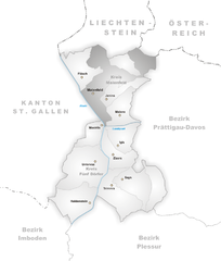
Тризен
Hiking in Тризен
Triesen, a charming municipality located in Liechtenstein, offers some wonderful hiking opportunities for outdoor enthusiasts. Nestled in the Rhine Valley, surrounded by scenic landscapes and the backdrop of the Alps, Triesen presents a variety of hiking trails suitable for different skill levels....
- Страна:
- Почтовый код: 9495
- Телефонный код: 7002
- Координаты: 47° 6' 0" N, 9° 31' 0" E
- GPS треки (wikiloc): [Ссылка]
- Высота над уровнем моря: 512 м m
- Площадь: 26.4 кв.км
- Веб сайт: [Ссылка]


Шан
Hiking in Шан
Schaan, located in Liechtenstein, is a great destination for hiking enthusiasts. It offers a picturesque landscape and access to various trails that cater to different skill levels. Here are some details about hiking in and around Schaan:...
- Страна:
- Почтовый код: 9494
- Телефонный код: 7005
- Координаты: 47° 10' 0" N, 9° 31' 0" E
- GPS треки (wikiloc): [Ссылка]
- Высота над уровнем моря: 450 м m
- Площадь: 26.8 кв.км
- Население: 5959
- Веб сайт: [Ссылка]


Планкен
Hiking in Планкен
Planken is a charming municipality located in the Principality of Liechtenstein. While it's not as well-known as some larger hiking destinations, it offers a variety of scenic trails suitable for different skill levels. Here are some key points to consider when hiking in Planken:...
- Страна:
- Почтовый код: 9498
- Телефонный код: 7006
- Координаты: 47° 10' 49" N, 9° 33' 36" E
- GPS треки (wikiloc): [Ссылка]
- Высота над уровнем моря: 786 м m
- Площадь: 5.3 кв.км
- Веб сайт: [Ссылка]
Майенфельд
Hiking in Майенфельд
Maienfeld, located in the canton of Graubünden in Switzerland, is a picturesque village famous for its stunning landscapes and wine production, particularly its Bündner wine. The area offers a variety of hiking trails that cater to different skill levels, providing hikers with breathtaking views of the surrounding Alps, charming vineyards, and lush meadows....
- Страна:

- Почтовый код: 7304
- Телефонный код: 081
- Код автомобильного номера: GR
- Координаты: 47° 0' 28" N, 9° 31' 51" E
- GPS треки (wikiloc): [Ссылка]
- Высота над уровнем моря: 1469 м m
- Площадь: 32.33 кв.км
- Население: 2860
- Веб сайт: [Ссылка]


Зарганс
Hiking in Зарганс
Sargans, located in the eastern part of Switzerland, offers a variety of beautiful hiking trails suitable for different skill levels, making it a great destination for outdoor enthusiasts. Nestled in the foothills of the Alps, Sargans provides stunning views of the surrounding mountains and valleys....
- Страна:
- Почтовый код: 7320
- Телефонный код: 081
- Код автомобильного номера: SG
- Координаты: 47° 2' 53" N, 9° 26' 23" E
- GPS треки (wikiloc): [Ссылка]
- Высота над уровнем моря: 483 м m
- Площадь: 9.48 кв.км
- Население: 6118
- Веб сайт: [Ссылка]


Флеш
Hiking in Флеш
Fläsch is a charming village located in the Bündner Herrschaft region of Switzerland, known for its stunning natural landscapes and excellent hiking opportunities. The area around Fläsch features a mix of vineyards, forests, and panoramic mountain views, making it an ideal destination for both casual walkers and experienced hikers....
- Страна:
- Почтовый код: 7306
- Телефонный код: 081
- Код автомобильного номера: GR
- Координаты: 47° 2' 23" N, 9° 31' 59" E
- GPS треки (wikiloc): [Ссылка]
- Высота над уровнем моря: 528 м m
- Площадь: 19.94 кв.км
- Население: 774
- Веб сайт: [Ссылка]


Вартау
Hiking in Вартау
Wartau, located in the canton of St. Gallen in Switzerland, is a beautiful destination for hiking enthusiasts. The region boasts stunning landscapes, including rolling hills, picturesque valleys, and views of the Swiss Alps....
- Страна:
- Почтовый код: 9478
- Телефонный код: 081
- Код автомобильного номера: SG
- Координаты: 47° 4' 59" N, 9° 29' 0" E
- GPS треки (wikiloc): [Ссылка]
- Высота над уровнем моря: 472 м m
- Площадь: 41.74 кв.км
- Население: 5296
- Веб сайт: [Ссылка]