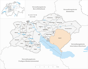
Беатенберг (Beatenberg, Beatenberg)

 Hiking in Беатенберг
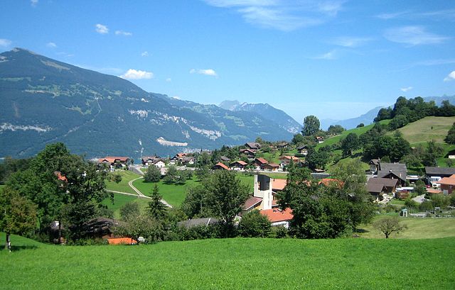
Beatenberg is a picturesque village located in the Swiss region of Bernese Oberland. It's renowned for its stunning panoramic views of the surrounding Alps and Lake Thun. The area is a fantastic destination for hikers of all levels, offering a variety of trails that showcase the beautiful landscapes.
Popular Hiking Trails:
-
Beatenberg to Niederhorn:
- Difficulty: Moderate
- Duration: Approximately 3-5 hours
- Description: This trail leads you up to the Niederhorn, where you'll enjoy breathtaking views over the Bernese Alps and Lake Thun. The route can be steep in sections, but the scenic rewards are well worth the effort.
-
Niederhorn to Habkern:
- Difficulty: Moderate
- Duration: Around 4 hours
- Description: This route offers a mix of forest trails and open meadows, with a great opportunity to spot wildlife. The views over the surrounding mountains and valleys are stunning.
-
Beatenberg Village Trails:
- Difficulty: Easy to Moderate
- Description: There are several shorter, well-marked trails around Beatenberg that are ideal for families or those looking for a leisurely hike. These trails often pass through charming villages and offer a chance to experience local flora and fauna.
-
The Panorama Trail:
- Difficulty: Easy to Moderate
- Duration: Varies
- Description: This trail provides spectacular views of Lake Thun and the distant peaks of the Eiger, Mönch, and Jungfrau. It’s well-maintained and suitable for all ages.
Practical Tips:
-
Best Time to Hike: The best hiking season in Beatenberg generally runs from late spring (May) to early autumn (October). Summer offers the best weather and longer days.
-
Equipment: Good hiking shoes are essential, and it’s advisable to bring trekking poles for more challenging routes. Dress in layers as the weather can change quickly in the mountains.
-
Safety: Always inform someone of your hiking plans, check the weather before heading out, and consider carrying a map or a GPS device. Some hikes may be more difficult in wet or slippery conditions.
-
Cultural Highlights: The area is rich in Swiss culture, and you might also want to visit local cheese farms or enjoy traditional Swiss cuisine in nearby restaurants.
-
Public Transport: Beatenberg is accessible via public transport, and there are local buses that can take you to different starting points for hiking.
Beatenberg is a charming place to explore, with its combination of natural beauty, well-marked trails, and opportunities for adventure. Be sure to take your time to soak in the stunning views and perhaps even spot some wildlife along your journey!
- Страна:

- Почтовый код: 3803
- Телефонный код: 033
- Код автомобильного номера: BE
- Координаты: 46° 42' 53" N, 7° 48' 16" E


- GPS треки (wikiloc): [Ссылка]
- Высота над уровнем моря: 1678 м m
- Площадь: 29.2 кв.км
- Население: 1208
- Веб сайт: http://www.beatenberg.ch
- Википедия русская: wiki(ru)
- Википедия английская: wiki(en)
- Википедия национальная: wiki(de)
- Хранилище Wikidata: Wikidata: Q68108
- Катеория в википедии: [Ссылка]
- код Freebase: [/m/0c89j2]
- код GeoNames: Альт: [7285173]
- код VIAF: Альт: [352145857874823020667]
- ID отношения в OpenStreetMap: [1682372]
- место в MusicBrainz: [af442bc8-e790-40a7-8bf5-3c4e4086c88a]
- идентификатор HDS: [326]
- код швейцарского муниципалитета: [0571]
Граничит с регионами:


Хабкерн
Hiking in Хабкерн
Habkern is a charming village located in the Bernese Oberland region of Switzerland, surrounded by stunning alpine scenery, making it a fantastic destination for hiking enthusiasts. The area offers a variety of trails that cater to different skill levels, from easy walks to more challenging hikes....
- Страна:
- Почтовый код: 3804
- Телефонный код: 033
- Код автомобильного номера: BE
- Координаты: 46° 45' 18" N, 7° 53' 24" E
- GPS треки (wikiloc): [Ссылка]
- Высота над уровнем моря: 1646 м m
- Площадь: 51.1 кв.км
- Население: 643
- Веб сайт: [Ссылка]
Эриц
Hiking in Эриц
Eriz, a small village located in the Bernese Oberland region of Switzerland, offers stunning landscapes and a variety of hiking trails suitable for different skill levels. Here’s an overview of what you can expect when hiking in Eriz:...
- Страна:
- Почтовый код: 3619
- Телефонный код: 033
- Код автомобильного номера: BE
- Координаты: 46° 47' 16" N, 7° 48' 42" E
- GPS треки (wikiloc): [Ссылка]
- Высота над уровнем моря: 1015 м m
- Площадь: 21.80 кв.км
- Население: 490
- Веб сайт: [Ссылка]


Дерлиген
Hiking in Дерлиген
Därligen is a charming village located near Lake Thun in the Bernese Oberland region of Switzerland. It's a fantastic area for hiking, offering stunning views of the lake and surrounding mountains, while also providing access to a variety of trails suitable for different skill levels....
- Страна:
- Почтовый код: 3707
- Телефонный код: 033
- Код автомобильного номера: BE
- Координаты: 46° 39' 12" N, 7° 48' 46" E
- GPS треки (wikiloc): [Ссылка]
- Высота над уровнем моря: 823 м m
- Площадь: 6.91 кв.км
- Население: 429
- Веб сайт: [Ссылка]
Хорренбах-Бухен
Hiking in Хорренбах-Бухен
Horrenbach-Buchen is a charming area situated in the heart of the Lower Austria region, known for its picturesque landscapes and extensive hiking opportunities. It offers a range of trails that cater to different skill levels, making it an excellent destination for both casual walkers and experienced hikers. Here are some highlights:...
- Страна:
- Почтовый код: 3623
- Телефонный код: 033
- Код автомобильного номера: BE
- Координаты: 46° 45' 59" N, 7° 44' 59" E
- GPS треки (wikiloc): [Ссылка]
- Высота над уровнем моря: 1000 м m
- Площадь: 20.37 кв.км
- Население: 226
- Веб сайт: [Ссылка]

Зигрисвиль
Hiking in Зигрисвиль
Sigriswil is a picturesque village located in the Canton of Bern, Switzerland, known for its stunning landscapes and beautiful hiking trails. Nestled near the shores of Lake Thun, Sigriswil offers a variety of hiking options suitable for different fitness levels, making it an attractive destination for outdoor enthusiasts....
- Страна:
- Почтовый код: 3655
- Телефонный код: 033
- Код автомобильного номера: BE
- Координаты: 46° 44' 7" N, 7° 44' 52" E
- GPS треки (wikiloc): [Ссылка]
- Высота над уровнем моря: 1349 м m
- Площадь: 55.34 кв.км
- Население: 4788
- Веб сайт: [Ссылка]

Краттиген
Hiking in Краттиген
Krattigen is a charming village located in the Bernese Oberland region of Switzerland, known for its stunning views of Lake Thun and the surrounding mountains. This area is a fantastic destination for hiking enthusiasts, offering a variety of trails suitable for different skill levels. Here are some highlights and tips for hiking in and around Krattigen:...
- Страна:
- Почтовый код: 3704
- Телефонный код: 033
- Код автомобильного номера: BE
- Координаты: 46° 39' 1" N, 7° 44' 25" E
- GPS треки (wikiloc): [Ссылка]
- Высота над уровнем моря: 932 м m
- Площадь: 6.0 кв.км
- Население: 1128
- Веб сайт: [Ссылка]


Унтерзен
Hiking in Унтерзен
Unterseen is a charming village located near Interlaken in Switzerland, surrounded by stunning landscapes that offer a variety of hiking opportunities for all levels of outdoor enthusiasts. Here are some highlights for hiking in and around Unterseen:...
- Страна:
- Почтовый код: 3800
- Телефонный код: 033
- Код автомобильного номера: BE
- Координаты: 46° 41' 14" N, 7° 50' 59" E
- GPS треки (wikiloc): [Ссылка]
- Высота над уровнем моря: 789 м m
- Площадь: 14.1 кв.км
- Население: 5712
- Веб сайт: [Ссылка]