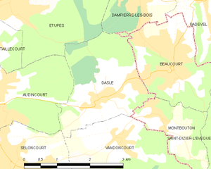
Beaucourt (Beaucourt)

- коммуна во Франции
 Hiking in Beaucourt
Beaucourt is a small commune in the Territoire de Belfort department in the Bourgogne-Franche-Comté region of France. While it may not be as widely recognized for hiking as some other areas, there are opportunities for outdoor activities in and around Beaucourt. Here's what you can expect:
Trails and Areas
-
Local Paths: Beaucourt features several local paths that can be explored, providing a chance to enjoy the natural landscape. These trails may be suitable for short hikes or leisurely walks.
-
Surrounding Nature: The region around Beaucourt offers various green spaces and wooded areas, which can be great for hiking. You can discover natural beauty while enjoying the tranquility of rural France.
-
Nearby Parks: You might also consider visiting nearby parks, such as the Parc Naturel Régional des Ballons des Vosges, which is a bit further afield. This park features well-marked hiking trails with varying difficulties and stunning landscapes.
Tips for Hiking in Beaucourt
- Maps and Guides: Check local maps to identify hiking trails. Local tourism offices can provide maps or guides to help you navigate the area.
- Weather: Always monitor the weather before heading out as conditions can change rapidly. Be prepared for rain or changes in temperature.
- Gear: Appropriate hiking gear is crucial. Wear sturdy footwear, dress in layers, and bring essentials like water, snacks, and a first-aid kit.
- Wildlife: Be aware of local wildlife and flora. Respect nature by sticking to marked trails and leaving no trace.
Local Amenities
- Village Amenities: Beaucourt has basic amenities such as shops and cafes for refreshments after your hike. It’s advisable to check ahead for specific opening hours.
Conclusion
While Beaucourt may not have extensive hiking trails, it offers a peaceful environment for walking and enjoying nature. For more adventurous hikes, consider venturing to nearby natural parks in the region. Always plan ahead and respect the natural environment during your hikes.
- Страна:

- Почтовый код: 90500
- Координаты: 47° 29' 10" N, 6° 55' 31" E


- GPS треки (wikiloc): [Ссылка]
- Площадь: 4.95 кв.км
- Население: 5090
- Веб сайт: http://www.beaucourt.fr
- Википедия английская: wiki(en)
- Википедия национальная: wiki(fr)
- Хранилище Wikidata: Wikidata: Q593729
- Катеория в википедии: [Ссылка]
- код Freebase: [/m/03mh90x]
- код Freebase: [/m/03mh90x]
- код Freebase: [/m/03mh90x]
- код GeoNames: Альт: [6613169]
- код GeoNames: Альт: [6613169]
- код GeoNames: Альт: [6613169]
- номер SIREN: [219000098]
- номер SIREN: [219000098]
- номер SIREN: [219000098]
- код BNF: [15279950v]
- код BNF: [15279950v]
- код BNF: [15279950v]
- код VIAF: Альт: [239989667]
- код VIAF: Альт: [239989667]
- код VIAF: Альт: [239989667]
- код GND: Альт: [4248985-4]
- код GND: Альт: [4248985-4]
- код GND: Альт: [4248985-4]
- место в MusicBrainz: [398270bf-ffe9-461a-86af-cf1b52ba87e8]
- место в MusicBrainz: [398270bf-ffe9-461a-86af-cf1b52ba87e8]
- место в MusicBrainz: [398270bf-ffe9-461a-86af-cf1b52ba87e8]
- код муниципалитета INSEE: 90009
- код муниципалитета INSEE: 90009
- код муниципалитета INSEE: 90009
Граничит с регионами:

Badevel
- коммуна во Франции
Hiking in Badevel
Badevel, a charming area in the Doubs department of France, offers a variety of hiking opportunities for enthusiasts of all skill levels. The region is characterized by its picturesque landscapes, which include rolling hills, dense forests, and scenic viewpoints. Here are some key highlights for hiking in Badevel:...
- Страна:
- Почтовый код: 25490
- Координаты: 47° 30' 0" N, 6° 56' 23" E
- GPS треки (wikiloc): [Ссылка]
- Площадь: 3.73 кв.км
- Население: 833

Dasle
- коммуна во Франции
Hiking in Dasle
Dasle is not a widely recognized hiking destination, so it seems there may be a confusion with the name or a lesser-known local trail. If you meant a specific area or region, please provide more details, such as the country or state....
- Страна:
- Почтовый код: 25230
- Координаты: 47° 28' 40" N, 6° 53' 39" E
- GPS треки (wikiloc): [Ссылка]
- Площадь: 5.67 кв.км
- Население: 1420


Dampierre-les-Bois
- коммуна во Франции
Hiking in Dampierre-les-Bois
Dampierre-les-Bois, located in the Doubs department in the Bourgogne-Franche-Comté region of eastern France, offers several opportunities for hiking enthusiasts. The area is characterized by its scenic landscapes, including rolling hills, forests, and meadows, which are ideal for both casual walkers and more serious hikers....
- Страна:
- Почтовый код: 25490
- Координаты: 47° 30' 25" N, 6° 54' 43" E
- GPS треки (wikiloc): [Ссылка]
- Площадь: 4.72 кв.км
- Население: 1659


Saint-Dizier-l'Évêque
- коммуна во Франции
Hiking in Saint-Dizier-l'Évêque
Saint-Dizier-l'Évêque is a quaint commune located in the Auvergne-Rhône-Alpes region of France, offering picturesque landscapes and a peaceful environment for hiking enthusiasts. Here are some key points to consider when planning a hike in this area:...
- Страна:
- Почтовый код: 90100
- Координаты: 47° 28' 15" N, 6° 57' 40" E
- GPS треки (wikiloc): [Ссылка]
- Площадь: 10.83 кв.км
- Население: 423


Montbouton
- коммуна во Франции
Hiking in Montbouton
Montbouton, while not prominently featured as a major hiking destination, is likely a local area that may offer beautiful trails and scenic views typical of many mountainous regions. To get the most from your hiking experience there, here are some general tips and information you might find useful:...
- Страна:
- Почтовый код: 90500
- Координаты: 47° 28' 22" N, 6° 55' 9" E
- GPS треки (wikiloc): [Ссылка]
- Площадь: 2.81 кв.км
- Население: 403