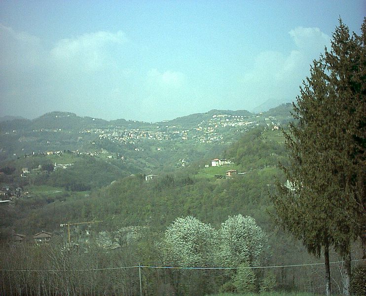
Бедулита (Bedulita, Bedulita)
.svg)
- коммуна Италии
 Hiking in Бедулита
Bedulita is a small village located in the province of Bergamo, Lombardy, Italy. It is situated in the foothills of the Alps, making it a great starting point for hiking and exploring the natural beauty of the surrounding area.
Hiking Trails:
-
Sentiero dei Fiori: This trail offers a delightful experience with various wildflowers and stunning views of the valley and surrounding mountains. It's a moderate hike suitable for families and less experienced hikers.
-
Monte Linzone: A popular destination for hikers, Monte Linzone offers several trail options of varying difficulties. The summit provides panoramic views of the Po Valley and the Alps. The trails are well-marked and can be accessed from Bedulita.
-
Valle Imagna: The valley is filled with numerous hiking paths, ranging from easy walks to more challenging routes. You can find trails that lead you through picturesque villages, forests, and along streams.
-
Traversata Alta: This higher-altitude trek takes you deeper into the mountains, offering breathtaking views and a more remote hiking experience. It’s recommended for experienced hikers due to its elevation and rugged terrain.
Tips for Hiking in Bedulita:
- Best Time to Hike: Spring and autumn are ideal for hiking because of the mild weather, while summer can get hot. Winter hikes are rewarding but require proper gear.
- Trail Markers: Familiarize yourself with local trail markers, such as red-and-white stripes, which help guide you. Always carry a map or GPS device.
- Pack Essentials: Bring plenty of water, snacks, a first-aid kit, and suitable clothing layers to accommodate changing weather conditions.
- Respect Nature: Stay on marked paths to protect the local flora and fauna. Carry out any waste to keep the trails clean.
Local Amenities:
Bedulita offers basic amenities including small shops or local eateries where you can try regional dishes. However, it’s advisable to plan for meals and snacks, especially if hiking for an extended period.
Whether you’re an experienced hiker or a beginner looking to enjoy nature, Bedulita provides a charming setting for outdoor activities. Enjoy your hike!
- Страна:

- Почтовый код: 24030
- Телефонный код: 035
- Код автомобильного номера: BG
- Координаты: 45° 47' 29" N, 9° 33' 4" E


- GPS треки (wikiloc): [Ссылка]
- Высота над уровнем моря: 600 м m
- Площадь: 4.27 кв.км
- Население: 732
- Веб сайт: http://www.comune.bedulita.bg.it
- Википедия русская: wiki(ru)
- Википедия английская: wiki(en)
- Википедия национальная: wiki(it)
- Хранилище Wikidata: Wikidata: Q99965
- Галерея изображений в википедии: [Ссылка]
- Катеория в википедии: [Ссылка]
- код Freebase: [/m/0gj8q1]
- код GeoNames: Альт: [6542552]
- код VIAF: Альт: [233920269]
- ID отношения в OpenStreetMap: [46142]
- код ISTAT: 016022
- кадастровый код Италии: A732
Граничит с регионами:


Капиццоне
- коммуна Италии
Hiking in Капиццоне
Capizzone is a charming town located in the Lombardy region of Italy, nestled in the foothills of the Alps. It is a great area for hiking enthusiasts, offering a variety of trails that showcase the stunning landscapes, lush greenery, and breathtaking views of the surrounding mountains and valleys....
- Страна:
- Почтовый код: 24030
- Телефонный код: 035
- Код автомобильного номера: BG
- Координаты: 45° 47' 8" N, 9° 34' 0" E
- GPS треки (wikiloc): [Ссылка]
- Высота над уровнем моря: 454 м m
- Площадь: 4.68 кв.км
- Население: 1231
- Веб сайт: [Ссылка]


Коста-Валле-Иманья
- коммуна Италии
Hiking in Коста-Валле-Иманья
Costa Valle Imagna, located in the Lombardy region of Italy, offers a wonderful hiking experience characterized by picturesque landscapes, charming villages, and a rich cultural heritage. Here are some key points about hiking in this area:...
- Страна:
- Почтовый код: 24030
- Телефонный код: 035
- Код автомобильного номера: BG
- Координаты: 45° 48' 0" N, 9° 30' 0" E
- GPS треки (wikiloc): [Ссылка]
- Высота над уровнем моря: 1014 м m
- Площадь: 4.21 кв.км
- Население: 587
- Веб сайт: [Ссылка]


Ронкола
- коммуна Италии
Hiking in Ронкола
Roncola is a picturesque area in Italy, situated in the Lombardy region, near the beautiful Bergamo Alps. It's known for its stunning landscapes, rich history, and various hiking opportunities. Here are some key points to consider if you're planning a hiking trip in and around Roncola:...
- Страна:
- Почтовый код: 24030
- Телефонный код: 035
- Код автомобильного номера: BG
- Координаты: 45° 46' 0" N, 9° 33' 0" E
- GPS треки (wikiloc): [Ссылка]
- Высота над уровнем моря: 854 м m
- Площадь: 5.07 кв.км
- Население: 780
- Веб сайт: [Ссылка]


Сант'Омобоно-Терме
- коммуна Италии
Hiking in Сант'Омобоно-Терме
Sant'Omobono Terme is a charming town located in the province of Bergamo, Lombardy, Italy. It is well-known for its thermal springs and beautiful surrounding landscapes, making it an attractive destination for hikers and outdoor enthusiasts....
- Страна:
- Почтовый код: 24038
- Телефонный код: 035
- Код автомобильного номера: BG
- Координаты: 45° 48' 33" N, 9° 32' 14" E
- GPS треки (wikiloc): [Ссылка]
- Высота над уровнем моря: 427 м m
- Площадь: 16.43 кв.км
- Население: 3940
- Веб сайт: [Ссылка]

Бербенно
- коммуна Италии
Hiking in Бербенно
Berbenno is a charming village located in the province of Sondrio, in the Lombardy region of northern Italy. Set against the stunning backdrop of the Italian Alps, it offers a variety of hiking opportunities that cater to different skill levels and preferences. Here are some highlights about hiking in and around Berbenno:...
- Страна:
- Почтовый код: 24030
- Телефонный код: 035
- Код автомобильного номера: BG
- Координаты: 45° 48' 49" N, 9° 34' 6" E
- GPS треки (wikiloc): [Ссылка]
- Высота над уровнем моря: 675 м m
- Площадь: 6.14 кв.км
- Население: 2357
- Веб сайт: [Ссылка]