Бинаско (Binasco, Binasco)
.svg)
- коммуна Италии
 Hiking in Бинаско
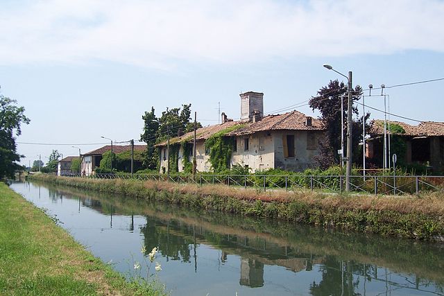
Binasco, a small town located in the Lombardy region of Italy, is nestled near the banks of the Naviglio Pavese, which provides charming scenery and potential hiking opportunities. While Binasco itself may not be a well-known hiking destination, several routes and areas nearby can offer enjoyable hikes.
Here are some aspects to consider for hiking in and around Binasco:
-
Naviglio Pavese: The canal is flanked by walking paths that are ideal for leisurely hikes or nature walks. You can enjoy the serenity of water views, passing boats, and local wildlife. The paths are generally flat and easy, making them suitable for hikers of all skill levels.
-
Parco Agricolo Sud Milano: Just a short distance from Binasco, this park features a variety of trails and natural landscapes, including fields, forests, and rivers. It’s a great place for hiking, biking, and enjoying the local flora and fauna.
-
Nature Reserves: Explore any nearby nature reserves that may offer well-marked trails. These areas often provide a more rugged hiking experience while allowing you to immerse yourself in local biodiversity.
-
Cultural and Historical Routes: In addition to natural landscapes, you might find routes that lead to historical sites and local landmarks, enhancing your hiking experience with cultural insights.
-
Preparation and Safety: Always check trail conditions before heading out. Bring appropriate gear, including sturdy hiking shoes, sufficient water, snacks, and possibly a map or a GPS device.
-
Local Weather: The weather in Lombardy can vary, so always check the forecast and be prepared for sudden changes, especially in the spring and autumn.
-
Nearby Trails: If you’re willing to travel a bit further, the surrounding area—especially the hills and parks outside Binasco—can offer more challenging hikes, such as those in the nearby hills of the Milanese hinterland.
Overall, while Binasco itself may not be a hiking hotspot, the surrounding region provides a variety of pleasant options for outdoor enthusiasts. Whether you’re looking for an easy stroll by the canal or a more robust hike in the countryside, you’re likely to find a route that suits your needs!
- Страна:

- Почтовый код: 20082
- Телефонный код: 02
- Код автомобильного номера: MI
- Координаты: 45° 20' 0" N, 9° 6' 0" E


- GPS треки (wikiloc): [Ссылка]
- Высота над уровнем моря: 101 м m
- Площадь: 3.87 кв.км
- Население: 7251
- Веб сайт: http://www.comunebinasco.it/
- Википедия русская: wiki(ru)
- Википедия английская: wiki(en)
- Википедия национальная: wiki(it)
- Хранилище Wikidata: Wikidata: Q43029
- Катеория в википедии: [Ссылка]
- код Freebase: [/m/0gj4pg]
- код GeoNames: Альт: [6537110]
- код VIAF: Альт: [158604056]
- ID отношения в OpenStreetMap: [44725]
- WOEID: [710995]
- UN/LOCODE: [ITBIO]
- код ISTAT: 015024
- кадастровый код Италии: A872
- LombardiaBeniCulturali toponym ID: 8000052
Граничит с регионами:


Казариле
- коммуна Италии
Hiking in Казариле
Casarile is a small town located in the Lombardy region of Italy, and while it may not be as famous for hiking as some other areas in Italy, it can serve as a good starting point for exploring the surrounding countryside....
- Страна:
- Почтовый код: 20080
- Телефонный код: 02
- Код автомобильного номера: MI
- Координаты: 45° 19' 0" N, 9° 6' 0" E
- GPS треки (wikiloc): [Ссылка]
- Высота над уровнем моря: 97 м m
- Площадь: 7.33 кв.км
- Население: 4081
- Веб сайт: [Ссылка]
Новильо
- коммуна Италии
Hiking in Новильо
Noviglio, located in the Lombardy region of Italy, offers a scenic backdrop for hiking enthusiasts, though it may not be as well-known as some of the major hiking destinations in the region. The area is characterized by its flat landscapes, vineyards, and agricultural fields, making it ideal for leisurely hikes rather than strenuous mountain trekking....
- Страна:
- Почтовый код: 20082
- Телефонный код: 02
- Код автомобильного номера: MI
- Координаты: 45° 22' 0" N, 9° 3' 0" E
- GPS треки (wikiloc): [Ссылка]
- Высота над уровнем моря: 103 м m
- Площадь: 15.86 кв.км
- Население: 4584
- Веб сайт: [Ссылка]
Лаккьярелла
- коммуна Италии
Hiking in Лаккьярелла
Lacchiarella is a small town in the Lombardy region of Italy, located near the metropolitan area of Milan. While it might not be a well-known hiking destination compared to other Italian locales like the Dolomites or Cinque Terre, there are still plenty of opportunities for pleasant walks and hikes in the surrounding areas....
- Страна:
- Почтовый код: 20084
- Телефонный код: 02
- Код автомобильного номера: MI
- Координаты: 45° 19' 30" N, 9° 8' 24" E
- GPS треки (wikiloc): [Ссылка]
- Высота над уровнем моря: 98 м m
- Площадь: 24.04 кв.км
- Население: 8964
- Веб сайт: [Ссылка]


Роццано
- коммуна Италии
Hiking in Роццано
Rozzano is a town located in the Lombardy region of Italy, approximately 10 kilometers south of Milan. While Rozzano itself is more urban and primarily residential, it serves as a convenient starting point for exploring the nearby natural areas and parks suitable for hiking....
- Страна:
- Почтовый код: 20089
- Телефонный код: 02
- Код автомобильного номера: MI
- Координаты: 45° 23' 0" N, 9° 9' 0" E
- GPS треки (wikiloc): [Ссылка]
- Высота над уровнем моря: 103 м m
- Площадь: 12.24 кв.км
- Население: 42417
- Веб сайт: [Ссылка]


Вернате
- коммуна Италии
Hiking in Вернате
Vernate is a small village located in the Lombardy region of Italy, not far from Milan. While it may not be as widely known for hiking as some other areas in Lombardy, it offers a charming landscape with some opportunities for outdoor activities, including hiking....
- Страна:
- Почтовый код: 20082
- Телефонный код: 02
- Код автомобильного номера: MI
- Координаты: 45° 19' 0" N, 9° 4' 0" E
- GPS треки (wikiloc): [Ссылка]
- Высота над уровнем моря: 108 м m
- Площадь: 14.65 кв.км
- Население: 3365
- Веб сайт: [Ссылка]

Цибидо-Сан-Джакомо
- коммуна Италии
Hiking in Цибидо-Сан-Джакомо
Zibido San Giacomo, a small town in the Lombardy region of Italy, is not as well-known for hiking as some other areas in the region, but it does offer opportunities for outdoor activities in its surrounding landscapes. Here are some key points about hiking in and around Zibido San Giacomo:...
- Страна:
- Почтовый код: 20080
- Телефонный код: 02
- Код автомобильного номера: MI
- Координаты: 45° 22' 0" N, 9° 7' 0" E
- GPS треки (wikiloc): [Ссылка]
- Высота над уровнем моря: 111 м m
- Площадь: 24.58 кв.км
- Население: 6856
- Веб сайт: [Ссылка]