Bissone (Bissone)

 Hiking in Bissone
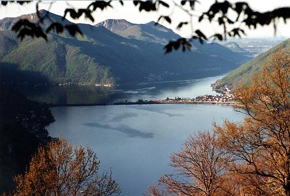
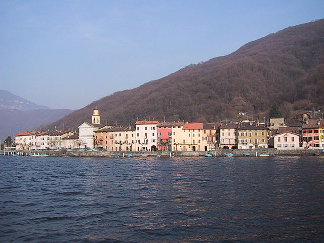
Bissone is a charming village located along Lake Lugano in the Canton of Ticino, Switzerland. It is surrounded by stunning landscapes and offers a variety of hiking opportunities that cater to different skill levels. Here’s what you need to know about hiking in and around Bissone:
Scenic Trails
-
Sentiero di Bissone: This picturesque trail runs along the lakeshore, providing stunning views of Lake Lugano and the surrounding mountains. It's relatively flat and suitable for all levels, making it a perfect leisurely hike.
-
Monte San Giorgio: A bit further away, Monte San Giorgio offers more challenging hikes. The mountain has well-marked trails that lead to panoramic views over the lake and surrounding regions. It’s renowned for its geological significance and is a UNESCO World Heritage site.
-
Path to Morcote: A popular route that connects Bissone to the nearby village of Morcote. This trail offers a mix of natural beauty and cultural experiences, passing through lush forests and quaint villages.
Key Points to Consider
- Preparation: Always check the weather conditions and trail information before heading out. Swiss weather can change rapidly, especially in mountainous areas.
- Gear: Wear sturdy hiking shoes, bring plenty of water, snacks, and a map or GPS device.
- Local Wildlife: Keep an eye out for local flora and fauna, and remember to practice Leave No Trace principles to preserve the natural environment.
- Public Transport: Bissone is well connected by public transport, making it easy to reach starting points for various trails.
Best Time to Hike
The ideal hiking season in Bissone is from late spring to early autumn (May to October), when the weather is generally mild and the trails are accessible. However, early autumn can also offer stunning fall foliage.
Conclusion
Hiking in Bissone provides beautiful scenery, a variety of trail options, and opportunities to explore the rich culture of the region. Whether you’re looking for a relaxing lakeside stroll or a more challenging mountain hike, Bissone has something to offer every nature enthusiast. Enjoy your adventure!
- Страна:

- Почтовый код: 6816
- Телефонный код: 091
- Код автомобильного номера: TI
- Координаты: 45° 57' 0" N, 8° 58' 0" E


- GPS треки (wikiloc): [Ссылка]
- Высота над уровнем моря: 273 м m
- Площадь: 1.8 кв.км
- Население: 926
- Веб сайт: http://www.bissone.ch
- Википедия английская: wiki(en)
- Википедия национальная: wiki(de)
- Хранилище Wikidata: Wikidata: Q69269
- Катеория в википедии: [Ссылка]
- код Freebase: [/m/0bt18x]
- код GeoNames: Альт: [2661486]
- код VIAF: Альт: [134707265]
- ID отношения в OpenStreetMap: [1684629]
- код GND: Альт: [4569075-3]
- идентификатор местоположения ArchINFORM: [1518]
- код LCNAF: Альт: [nr94027519]
- место в MusicBrainz: [dd78deee-75a0-4438-8fdd-20aa3987fb03]
- идентификатор HDS: [2142]
- код швейцарского муниципалитета: [5154]
Граничит с регионами:


Кампионе-д’Италия
- коммуна Италии
Hiking in Кампионе-д’Италия
Campione d'Italia is a unique and picturesque location situated on the shores of Lake Lugano in Switzerland, while being an Italian exclave. Its stunning landscape makes it an appealing destination for hikers....
- Страна:

- Почтовый код: I-22060; CH-6911; 6911; 22060
- Телефонный код: 004191; 091
- Код автомобильного номера: CO
- Координаты: 45° 58' 15" N, 8° 58' 15" E
- GPS треки (wikiloc): [Ссылка]
- Высота над уровнем моря: 273 м m
- Площадь: 1.6 кв.км
- Население: 1971
- Веб сайт: [Ссылка]

Riva San Vitale
Hiking in Riva San Vitale
Riva San Vitale is a picturesque town located on the shores of Lake Lugano in Switzerland, surrounded by stunning mountains, making it a great destination for hiking enthusiasts. Here are some highlights and information about hiking in this beautiful area:...
- Страна:
- Почтовый код: 6826
- Телефонный код: 091
- Код автомобильного номера: TI
- Координаты: 45° 54' 0" N, 8° 58' 0" E
- GPS треки (wikiloc): [Ссылка]
- Высота над уровнем моря: 273 м m
- Площадь: 5.9 кв.км
- Население: 2617
- Веб сайт: [Ссылка]


Arogno
Hiking in Arogno
Arogno is a small municipality in the canton of Ticino in southern Switzerland, nestled in the foothills of the Swiss Alps. It's known for its beautiful landscapes, charming villages, and rich cultural heritage. Hiking in Arogno offers a delightful experience, with picturesque trails that showcase stunning views of the surrounding mountains, valleys, and Lake Lugano....
- Страна:
- Почтовый код: 6822
- Телефонный код: 091
- Код автомобильного номера: TI
- Координаты: 45° 58' 0" N, 8° 59' 0" E
- GPS треки (wikiloc): [Ссылка]
- Высота над уровнем моря: 606 м m
- Площадь: 8.53 кв.км
- Население: 1011
- Веб сайт: [Ссылка]

Melide
Hiking in Melide
Melide, located in the picturesque region of Ticino, Switzerland, is a charming village situated alongside Lake Lugano. It serves as an excellent base for hiking enthusiasts who want to explore the stunning landscapes of the Swiss countryside and the surrounding mountains....
- Страна:
- Почтовый код: 6815
- Телефонный код: 091
- Код автомобильного номера: TI
- Координаты: 45° 57' 24" N, 8° 56' 39" E
- GPS треки (wikiloc): [Ссылка]
- Высота над уровнем моря: 368 м m
- Площадь: 1.70 кв.км
- Население: 1816
- Веб сайт: [Ссылка]

Brusino Arsizio
Hiking in Brusino Arsizio
Brusino Arsizio is a picturesque village located in the Swiss region of Ticino, near the shores of Lake Lugano. It's an excellent destination for hiking enthusiasts, offering a variety of trails that cater to different skill levels. Here are some highlights of hiking in this area:...
- Страна:
- Почтовый код: 6827
- Телефонный код: 091
- Код автомобильного номера: TI
- Координаты: 45° 55' 42" N, 8° 56' 19" E
- GPS треки (wikiloc): [Ссылка]
- Высота над уровнем моря: 551 м m
- Площадь: 5.78 кв.км
- Население: 485
- Веб сайт: [Ссылка]


Maroggia
Hiking in Maroggia
Maroggia is a charming village located on the shores of Lake Lugano in the canton of Ticino, Switzerland. It is surrounded by stunning landscapes that offer various hiking opportunities for different skill levels. Here’s an overview of what you can expect when hiking in and around Maroggia:...
- Страна:
- Почтовый код: 6817
- Телефонный код: 091
- Код автомобильного номера: TI
- Координаты: 45° 56' 17" N, 8° 58' 25" E
- GPS треки (wikiloc): [Ссылка]
- Высота над уровнем моря: 380 м m
- Площадь: 1.0 кв.км
- Население: 683
- Веб сайт: [Ссылка]