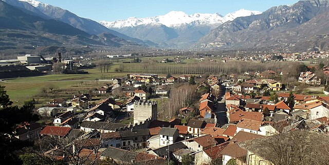
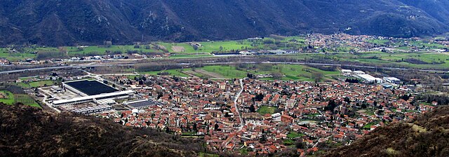
Боргоне-Суза (Borgone Susa, Borgone Susa)

- коммуна Италии
 Hiking in Боргоне-Суза
Borgone Susa is a charming village located in the Susa Valley in the Piedmont region of Italy. Surrounded by the breathtaking peaks of the Alps, it offers a variety of hiking opportunities that cater to different skill levels, making it an ideal destination for both beginner and experienced hikers.
Hiking Trails and Areas
-
The Susa Valley Trails: The Susa Valley is dotted with numerous trails that offer stunning views of the mountains and valleys. You can find well-marked paths ranging from easy walks to more challenging hikes. Some trails can lead you to historical sites, churches, and picturesque villages.
-
Monte Rocciamelone: This peak is a popular hiking destination near Borgone Susa. The hike to Monte Rocciamelone is quite challenging, but it’s rewarded with panoramic views of the surrounding mountains. The trail begins in the nearby town and takes you through forested areas and alpine meadows.
-
Gite e Rifugi: Along many hiking paths, you’ll find mountain huts (rifugi) that offer food and shelter. These places are perfect for resting while enjoying some local cuisine and soaking in the views.
-
Nature Reserves: Explore the nearby natural parks such as the Gran Bosco di Salbertrand Natural Park, which features diverse flora and fauna, making it a great destination for nature lovers and bird watchers.
Best Time to Hike
- Spring and Fall: These seasons are ideal for hiking, as the weather is usually mild, and the trails are less crowded. The wildflowers in spring are particularly beautiful.
- Summer: While summer offers clear skies and long days, some trails can be busy. Be cautious with hydration and sun protection.
- Winter: If you’re interested in snowshoeing or winter hiking, Borgone Susa provides opportunities for winter sports, although trail access may depend on snow conditions.
Important Tips
- Preparation: Always prepare properly with appropriate gear, including sturdy hiking boots, water, snacks, and a map or a GPS device.
- Local Guides: Consider hiring a local guide or joining a hiking group. They can provide insights into the area’s natural and cultural history and ensure a safe experience.
- Respect Nature: Follow the Leave No Trace principles. Stick to marked trails, and be mindful of local wildlife and plant life.
Borgone Susa, with its stunning landscapes and rich cultural heritage, is a fantastic spot for hiking enthusiasts looking to explore the Italian Alps. Whether you’re on a casual stroll or a challenging trek, you’re bound to enjoy the beauty of this region.
- Страна:

- Почтовый код: 10050
- Телефонный код: 011
- Код автомобильного номера: TO
- Координаты: 45° 7' 23" N, 7° 14' 28" E


- GPS треки (wikiloc): [Ссылка]
- Высота над уровнем моря: 394 м m
- Площадь: 4.96 кв.км
- Население: 2205
- Веб сайт: http://www.comune.borgonesusa.to.it
- Википедия русская: wiki(ru)
- Википедия английская: wiki(en)
- Википедия национальная: wiki(it)
- Хранилище Wikidata: Wikidata: Q9069
- Катеория в википедии: [Ссылка]
- код Freebase: [/m/0g6t09]
- код GeoNames: Альт: [6541431]
- код VIAF: Альт: [238812965]
- ID отношения в OpenStreetMap: [44250]
- WOEID: [711253]
- код TGN: [7058540]
- UN/LOCODE: [ITUSG]
- код ISTAT: 001032
- кадастровый код Италии: B024
Граничит с регионами:

Сан-Дидеро
- коммуна Италии
Hiking in Сан-Дидеро
It seems there might be a mix-up with the name "San Didero," as it doesn’t correspond to a well-known hiking destination. However, if you meant a different location—such as San Didero in Italy or perhaps a nearby area—please let me know!...
- Страна:
- Почтовый код: 10050
- Телефонный код: 011
- Код автомобильного номера: TO
- Координаты: 45° 8' 0" N, 7° 13' 0" E
- GPS треки (wikiloc): [Ссылка]
- Высота над уровнем моря: 430 м m
- Площадь: 3.3 кв.км
- Население: 537
- Веб сайт: [Ссылка]


Сант'Антонино-ди-Суза
- коммуна в Италии
Hiking in Сант'Антонино-ди-Суза
Sant'Antonino di Susa is located in the Susa Valley of the Piedmont region in northern Italy, and it's known for its stunning natural landscapes and outdoor recreational opportunities, particularly hiking. The area is rich in history, culture, and scenic vistas, making it an attractive destination for hikers of all abilities....
- Страна:
- Почтовый код: 10050
- Телефонный код: 011
- Код автомобильного номера: TO
- Координаты: 45° 6' 25" N, 7° 16' 20" E
- GPS треки (wikiloc): [Ссылка]
- Площадь: 9.79 кв.км
- Население: 4251
- Веб сайт: [Ссылка]


Виллар-Фоккьярдо
- коммуна в Италии
Hiking in Виллар-Фоккьярдо
Villar Focchiardo is a beautiful destination for hiking enthusiasts located in the Piedmont region of Italy, not far from the larger city of Turin. This area is characterized by its stunning natural landscapes, including lush valleys, rolling hills, and various flora and fauna. Here’s what you need to know about hiking in Villar Focchiardo:...
- Страна:
- Почтовый код: 10050
- Телефонный код: 011
- Код автомобильного номера: TO
- Координаты: 45° 7' 0" N, 7° 14' 0" E
- GPS треки (wikiloc): [Ссылка]
- Площадь: 25.69 кв.км
- Население: 1987
- Веб сайт: [Ссылка]

Кондове
- коммуна Италии
Hiking in Кондове
Condove is a small town located in the Susa Valley, within the Piedmont region of Italy. It's surrounded by stunning natural scenery, making it a wonderful spot for hiking and outdoor activities. The area is characterized by its picturesque landscapes, including the impressive peaks of the Susa Alps....
- Страна:
- Почтовый код: 10055
- Телефонный код: 011
- Код автомобильного номера: TO
- Координаты: 45° 7' 0" N, 7° 19' 0" E
- GPS треки (wikiloc): [Ссылка]
- Высота над уровнем моря: 376 м m
- Площадь: 71.11 кв.км
- Население: 4614
- Веб сайт: [Ссылка]