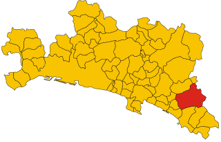
Борцонаска (Borzonasca, Borzonasca)
.svg)
- коммуна Италии
 Hiking in Борцонаска
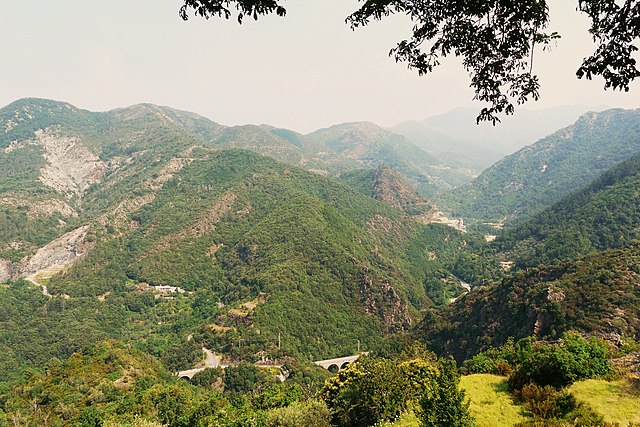
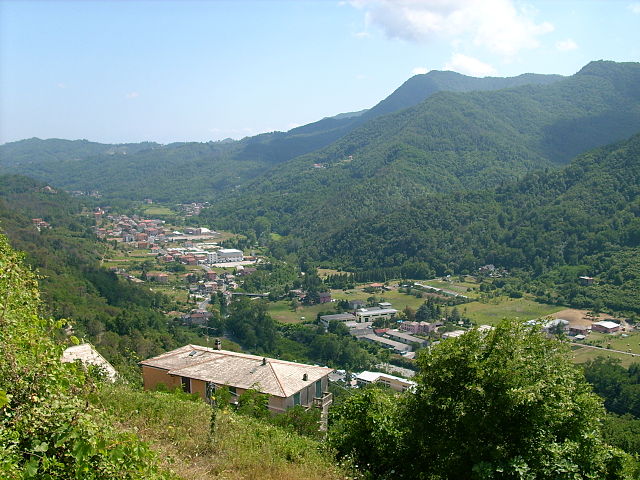
Borzonasca, located in the Liguria region of Italy, is known for its stunning natural beauty and offers a variety of hiking opportunities that showcase the picturesque landscapes of the Apennine Mountains. Here are some key points about hiking in Borzonasca:
Trails and Natural Attractions:
-
Wild Nature: The area is characterized by lush forests, beautiful valleys, and panoramic views. Hikers can expect a mix of challenging and moderate trails suitable for different skill levels.
-
Giovanni Paolo II Trail: This trail connects several villages and offers spectacular views, allowing hikers to experience the cultural heritage of the region alongside its natural beauty.
-
Val Gravesciano: This is part of the regional park and features trails that take you through varied terrains, including river valleys and rich woodlands.
-
Monte Tregin: A popular destination for hikers seeking a higher elevation and breathtaking views. The summit offers panoramic vistas of the surrounding mountains and valleys.
Wildlife and Flora:
- The area is rich in biodiversity, and you may encounter various wildlife species, including deer and several bird species. The flora includes a mix of native plants, herbs, and trees, making it a delight for nature enthusiasts.
Best Time to Hike:
- The best seasons for hiking in Borzonasca are spring (April to June) and early autumn (September to October), when the weather is mild and the landscapes are particularly vibrant. Summer can be hot, while winter hikes require proper preparation due to snow and colder temperatures.
Tips for Hikers:
- Preparation: Make sure to wear proper hiking boots and bring enough water and snacks. It's also essential to have a map or GPS device.
- Local Guidance: Consider hiring a local guide for a more informed experience about the trails and surrounding area, especially if you are unfamiliar with hiking in mountainous regions.
- Respect Nature: Stay on marked trails, carry out what you bring in, and respect local wildlife.
Cultural Experience:
- Borzonasca and the surrounding areas offer a chance to experience local culture and cuisine. Don’t miss out on trying regional dishes, such as pesto and local cheeses, at nearby restaurants or farms.
Overall, hiking in Borzonasca is an enriching experience that combines outdoor adventure with the beauty of nature and the charm of Italian culture. Whether you’re looking for a leisurely walk or a challenging trek, there’s something for everyone in this beautiful region of Liguria.
- Страна:

- Почтовый код: 16041
- Телефонный код: 0185
- Код автомобильного номера: GE
- Координаты: 44° 25' 20" N, 9° 23' 13" E


- GPS треки (wikiloc): [Ссылка]
- Высота над уровнем моря: 167 м m
- Площадь: 80.51 кв.км
- Население: 2035
- Веб сайт: http://www.comuneborzonasca.it/
- Википедия русская: wiki(ru)
- Википедия английская: wiki(en)
- Википедия национальная: wiki(it)
- Хранилище Wikidata: Wikidata: Q267134
- Катеория в википедии: [Ссылка]
- код Freebase: [/m/0gb_fm]
- код GeoNames: Альт: [6537057]
- код VIAF: Альт: [234799596]
- ID отношения в OpenStreetMap: [43132]
- код темы Quora: [Borzonasca]
- UN/LOCODE: [ITZBB]
- код ISTAT: 010005
- кадастровый код Италии: B067
Граничит с регионами:


Торноло
- коммуна Италии
Hiking in Торноло
Tornolo, located in the province of Parma in the Emilia-Romagna region of northern Italy, is a fantastic destination for hiking enthusiasts. This area offers diverse landscapes, ranging from lush forests to rocky outcrops, making it appealing for both novice and experienced hikers....
- Страна:
- Почтовый код: 43059
- Телефонный код: 0525
- Код автомобильного номера: PR
- Координаты: 44° 29' 0" N, 9° 38' 0" E
- GPS треки (wikiloc): [Ссылка]
- Высота над уровнем моря: 620 м m
- Площадь: 67.48 кв.км
- Население: 963
- Веб сайт: [Ссылка]
Не
- коммуна Италии
Hiking in Не
Hiking in Liguria, particularly in the region's northeastern part, offers stunning landscapes, charming villages, and a diverse range of trails suitable for various skill levels. The area is known for its picturesque coastline, impressive mountains, and historical sites. Here are some key highlights and recommendations for hiking in this beautiful region:...
- Страна:
- Почтовый код: 16040
- Телефонный код: 0185
- Код автомобильного номера: GE
- Координаты: 44° 20' 40" N, 9° 23' 55" E
- GPS треки (wikiloc): [Ссылка]
- Высота над уровнем моря: 68 м m
- Площадь: 63.52 кв.км
- Население: 2220
- Веб сайт: [Ссылка]


Реццоальйо
- коммуна Италии
Hiking in Реццоальйо
Rezzoaglio is a picturesque area located in the Liguria region of Italy, surrounded by the Apennine Mountains. It's an excellent destination for hikers due to its diverse landscapes, including lush forests, stunning valleys, and panoramic views. Here are some highlights and tips for hiking in Rezzoaglio:...
- Страна:
- Почтовый код: 16048
- Телефонный код: 0185
- Код автомобильного номера: GE
- Координаты: 44° 31' 35" N, 9° 23' 12" E
- GPS треки (wikiloc): [Ссылка]
- Высота над уровнем моря: 700 м m
- Площадь: 104.72 кв.км
- Население: 964
- Веб сайт: [Ссылка]


Санто-Стефано-д'Авето
- коммуна Италии
Hiking in Санто-Стефано-д'Авето
Santo Stefano d'Aveto is a picturesque village located in the Ligurian Apennines of Italy, known for its stunning landscapes and scenic hiking trails. The area offers a variety of hiking opportunities suitable for different skill levels, from easy walks to more challenging hikes. Here are some key aspects to consider when hiking in Santo Stefano d'Aveto:...
- Страна:
- Почтовый код: 16049
- Телефонный код: 0185
- Код автомобильного номера: GE
- Координаты: 44° 32' 52" N, 9° 27' 3" E
- GPS треки (wikiloc): [Ссылка]
- Высота над уровнем моря: 1012 м m
- Площадь: 54.78 кв.км
- Население: 1098
- Веб сайт: [Ссылка]

Меццанего
- коммуна Италии
Hiking in Меццанего
Mezzanego is a picturesque municipality located in the Liguria region of Italy, nestled in the hills between the coast and the Apennine mountain range. The area is well-known for its stunning natural landscapes, rich biodiversity, and charming village atmospheres....
- Страна:
- Почтовый код: 16046
- Телефонный код: 0185
- Код автомобильного номера: GE
- Координаты: 44° 23' 1" N, 9° 22' 38" E
- GPS треки (wikiloc): [Ссылка]
- Высота над уровнем моря: 83 м m
- Площадь: 28.65 кв.км
- Население: 1541
- Веб сайт: [Ссылка]

Сан-Коломбано-Чертеноли
- коммуна Италии
Hiking in Сан-Коломбано-Чертеноли
San Colombano Certénoli is a charming town located in the Liguria region of northern Italy, nestled in the hills of the Val Fontanabuona. The area is known for its beautiful landscapes, olive groves, and panoramic views, making it an appealing destination for hiking enthusiasts....
- Страна:
- Почтовый код: 16040
- Телефонный код: 0185
- Код автомобильного номера: GE
- Координаты: 44° 22' 18" N, 9° 18' 42" E
- GPS треки (wikiloc): [Ссылка]
- Высота над уровнем моря: 40 м m
- Площадь: 41.58 кв.км
- Население: 2632
- Веб сайт: [Ссылка]


Варезе-Лигуре
- коммуна Италии
Hiking in Варезе-Лигуре
Varese Ligure is a picturesque village located in the heart of the Ligurian Apennines in Italy. It’s known for its beautiful landscapes, charming architecture, and extensive network of hiking trails that cater to various skill levels. Here are some highlights if you're considering hiking in the area:...
- Страна:
- Почтовый код: 19028
- Телефонный код: 0187
- Код автомобильного номера: SP
- Координаты: 44° 22' 41" N, 9° 35' 45" E
- GPS треки (wikiloc): [Ссылка]
- Высота над уровнем моря: 353 м m
- Площадь: 137.59 кв.км
- Население: 1984
- Веб сайт: [Ссылка]