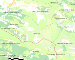
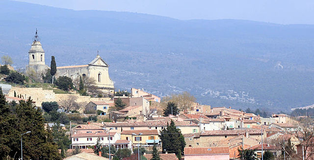
Брант (Brantes, Brantes)

- коммуна во Франции
 Hiking in Брант
Brantes is a picturesque village located in the Vaucluse department of the Provence region in France. It’s known for its stunning landscapes, charming architecture, and proximity to the Mont Ventoux area, making it a great base for hiking enthusiasts.
Hiking Trails
Brantes offers several hiking trails that cater to various skill levels, from easy walks to more challenging hikes:
-
Sentier de la Lavande:
- A beautiful trail that takes you through fields of lavender and offers lovely views of the surrounding countryside, especially during the blooming season in late June to early July.
-
Mont Ventoux:
- While Brantes is not directly on Mont Ventoux, it serves as a starting point for routes leading to the summit. The ascent is challenging but rewards hikers with panoramic views from the top.
-
Les Gorges de la Nesque:
- A stunning trail that follows the Nesque River, offering dramatic views of cliffs and lush vegetation. The route provides opportunities for photography and wildlife observation.
-
Trail to the Col de l'Homme Mort:
- This trail takes you through forests and offers breathtaking views of the mountains. It can be a strenuous hike, so it’s recommended for more experienced hikers.
Preparation and Safety
- Weather Conditions: The weather in this region can change rapidly, especially on Mont Ventoux, so always check the forecast before heading out.
- Footwear: Wear sturdy hiking boots as some trails can be rocky or uneven.
- Hydration and Snacks: Carry enough water and snacks, especially for longer hikes. There are limited facilities along many trails.
- Maps and Guides: It’s advisable to have a physical map or hiking guide, as some trails may not be well-marked.
Best Time to Hike
Spring and early fall are typically the best times for hiking in Brantes, as the weather is mild, and the natural scenery is at its most vibrant. Summer can be quite hot, particularly on exposed trails, while winter may see snow, particularly on higher elevations like Mont Ventoux.
Local Tips
- Try to engage with local hiking groups or guides for a more immersive experience and to learn about the area's flora and fauna.
- After a day of hiking, enjoy some of the local cuisine in Brantes, which often features fresh, local produce and traditional Provençal dishes.
Whether you’re looking for a casual walk or a more rigorous hike, Brantes has something to offer for everyone in a setting that showcases the natural beauty of Provence.
- Страна:

- Почтовый код: 84390
- Координаты: 44° 11' 36" N, 5° 20' 0" E


- GPS треки (wikiloc): [Ссылка]
- Площадь: 28.18 кв.км
- Население: 81
- Википедия русская: wiki(ru)
- Википедия английская: wiki(en)
- Википедия национальная: wiki(fr)
- Хранилище Wikidata: Wikidata: Q626017
- Катеория в википедии: [Ссылка]
- код Freebase: [/m/0c3b66]
- код GeoNames: Альт: [3030537]
- номер SIREN: [218400216]
- код BNF: [15278001x]
- код тезауруса PACTOLS: [pcrt1U7V5Bjqi3]
- код муниципалитета INSEE: 84021
Граничит с регионами:


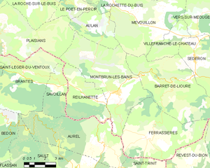
Reilhanette
- коммуна во Франции
Hiking in Reilhanette
Reilhanette, a charming village located in the heart of the Drôme region in southeastern France, offers a beautiful setting for hiking enthusiasts. The area is known for its stunning natural landscapes, including rolling hills, forests, and panoramic views of the surrounding mountains....
- Страна:
- Почтовый код: 26570
- Координаты: 44° 10' 8" N, 5° 25' 12" E
- GPS треки (wikiloc): [Ссылка]
- Площадь: 14.78 кв.км
- Население: 145

Plaisians
- коммуна во Франции
Hiking in Plaisians
Plaisians is a charming village located in the southern part of France, nestled in the picturesque region of the Vaucluse in Provence. It offers stunning landscapes, including rolling hills, vineyards, and forests, making it a fantastic destination for hiking enthusiasts....
- Страна:
- Почтовый код: 26170
- Координаты: 44° 13' 45" N, 5° 19' 3" E
- GPS треки (wikiloc): [Ссылка]
- Площадь: 29.64 кв.км
- Население: 195


Орель
Hiking in Орель
Aurel is a charming village nestled in the Vaucluse department of Provence, France. The area offers stunning landscapes, rich history, and a variety of trails for hikers of all levels. Here’s an overview of what you can expect when hiking in and around Aurel:...
- Страна:
- Почтовый код: 84390
- Координаты: 44° 7' 46" N, 5° 25' 42" E
- GPS треки (wikiloc): [Ссылка]
- Площадь: 28.9 кв.км
- Население: 207
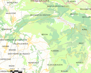
Бедуан
- коммуна во Франции
Hiking in Бедуан
Bédoin is a picturesque village located at the foot of Mont Ventoux in the Provence region of France, making it a fantastic destination for hiking enthusiasts. Here are some highlights and tips for hiking in Bédoin:...
- Страна:
- Почтовый код: 84410
- Координаты: 44° 7' 24" N, 5° 10' 47" E
- GPS треки (wikiloc): [Ссылка]
- Площадь: 91.03 кв.км
- Население: 3087
- Веб сайт: [Ссылка]


Сен-Леже-дю-Ванту
- коммуна во Франции
Hiking in Сен-Леже-дю-Ванту
Saint-Léger-du-Ventoux is a charming village located in the Vaucluse department of the Provence-Alpes-Côte d'Azur region in southern France, at the foot of the iconic Mont Ventoux. This area is known for its stunning landscapes, diverse flora and fauna, and excellent hiking opportunities....
- Страна:
- Почтовый код: 84390
- Координаты: 44° 12' 44" N, 5° 16' 32" E
- GPS треки (wikiloc): [Ссылка]
- Площадь: 19.29 кв.км
- Население: 37

Montbrun-les-Bains
- коммуна во Франции
Hiking in Montbrun-les-Bains
Montbrun-les-Bains is a charming village located in the Drôme department of southeastern France, nestled in the foothills of the Mont Ventoux. This picturesque area is known for its stunning landscapes, thermal springs, and rich history, making it a great destination for hiking enthusiasts....
- Страна:
- Почтовый код: 26570
- Координаты: 44° 10' 32" N, 5° 26' 35" E
- GPS треки (wikiloc): [Ссылка]
- Площадь: 33.26 кв.км
- Население: 433
- Веб сайт: [Ссылка]


Савуаллан
- коммуна во Франции
Hiking in Савуаллан
Savoillan is a lesser-known area located in the French Alps, known for its stunning natural beauty and diverse hiking opportunities. Hiking in Savoillan offers a chance to explore picturesque landscapes, from lush forests to alpine meadows and breathtaking mountain vistas....
- Страна:
- Почтовый код: 84390
- Координаты: 44° 10' 47" N, 5° 22' 27" E
- GPS треки (wikiloc): [Ссылка]
- Площадь: 8.81 кв.км
- Население: 77