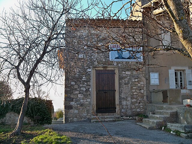
Серест (Céreste, Céreste)
- коммуна во Франции
 Hiking in Серест
Céreste is a charming village located in the Provence region of southeastern France, nestled in the Luberon mountains. It offers a variety of hiking opportunities that showcase the stunning natural beauty and rich cultural heritage of the area.
Hiking Trails
-
Luberon Regional Nature Park: Céreste is adjacent to the Luberon, a massive park filled with diverse landscapes including hills, vineyards, and forests. There are numerous well-marked trails ranging from easy walks to more challenging hikes.
-
Sentier des Plantades: This scenic loop trail starts near Céreste and takes you through orchards and vineyards, providing picturesque views of the rolling countryside. It’s suitable for families and beginner hikers.
-
Mountagne de Lure: For those seeking a more challenging hike, the nearby Mountagne de Lure offers robust trails with rewarding views of the surrounding valleys and peaks.
Flora and Fauna
The region is rich in biodiversity, with numerous opportunities for birdwatching and observing local wildlife. You'll likely encounter unique Mediterranean flora including lavender, olive trees, and various wildflowers, especially in spring and early summer.
Best Time to Hike
- Spring (April to June): This is one of the best times to hike as the weather is mild, wildflowers are blooming, and the trails are less crowded.
- Fall (September to October): Another excellent time for hiking, with cooler temperatures and beautiful autumn colors.
Practical Tips
-
What to Bring: Always wear sturdy hiking boots, bring plenty of water, snacks, and a map or GPS device. A first-aid kit and sun protection are also recommended.
-
Respect Nature: Stay on designated trails, carry out any trash, and respect local wildlife and vegetation.
-
Local Guides: If you're unfamiliar with the area, consider hiring a local guide who can provide insights into the landscapes and cultural history of the Luberon region.
-
Weather Check: Always check the local weather conditions before setting off, as they can change quickly, especially in mountainous areas.
Hiking in and around Céreste is a fantastic way to experience the natural beauty of Provence while enjoying the tranquility of the countryside.
- Страна:

- Почтовый код: 04280
- Координаты: 43° 51' 21" N, 5° 35' 14" E


- GPS треки (wikiloc): [Ссылка]
- Площадь: 32.54 кв.км
- Население: 1194
- Википедия русская: wiki(ru)
- Википедия английская: wiki(en)
- Википедия национальная: wiki(fr)
- Хранилище Wikidata: Wikidata: Q865855
- Катеория в википедии: [Ссылка]
- код Freebase: [/m/03m7w7q]
- код Freebase: [/m/03m7w7q]
- код GeoNames: Альт: [3027889]
- код GeoNames: Альт: [3027889]
- номер SIREN: [210400453]
- номер SIREN: [210400453]
- код VIAF: Альт: [125690996]
- код VIAF: Альт: [125690996]
- код Цифрового атласа Римской империи: [8041]
- код Цифрового атласа Римской империи: [8041]
- код муниципалитета INSEE: 04045
- код муниципалитета INSEE: 04045
Граничит с регионами:

Рейан
- коммуна во Франции
Hiking in Рейан
Reillanne, a charming village in the Luberon region of Provence, France, offers a delightful hiking experience set against a backdrop of stunning landscapes, vineyards, and olive groves. Here are some highlights and tips for hiking in and around Reillanne:...
- Страна:
- Почтовый код: 04110
- Координаты: 43° 52' 45" N, 5° 39' 33" E
- GPS треки (wikiloc): [Ссылка]
- Площадь: 38.55 кв.км
- Население: 1621

Сент-Круа-а-Лоз
- коммуна во Франции
Hiking in Сент-Круа-а-Лоз
Sainte-Croix-à-Lauze is a charming small commune located in the Alpes-de-Haute-Provence region of France. It is surrounded by beautiful natural landscapes, making it an appealing destination for hikers and outdoor enthusiasts....
- Страна:
- Почтовый код: 04110
- Координаты: 43° 54' 31" N, 5° 37' 2" E
- GPS треки (wikiloc): [Ссылка]
- Площадь: 8.65 кв.км
- Население: 84
Монжюстен
- коммуна во Франции
Hiking in Монжюстен
Montjustin is a charming village in the Provence-Alpes-Côte d'Azur region of France, nestled in the picturesque landscapes of the Luberon area. The region is known for its stunning natural beauty, quaint villages, and rich history, making it a wonderful destination for hiking enthusiasts....
- Страна:
- Почтовый код: 04110
- Координаты: 43° 50' 57" N, 5° 38' 5" E
- GPS треки (wikiloc): [Ссылка]
- Площадь: 10.15 кв.км
- Население: 56

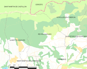
Пейпен-д'Эг
- коммуна во Франции
Hiking in Пейпен-д'Эг
Peypin-d'Aigues, located in the Vaucluse department of the Provence-Alpes-Côte d'Azur region in southeastern France, is a charming village that offers various hiking opportunities in the stunning landscapes of the Luberon region....
- Страна:
- Почтовый код: 84240
- Координаты: 43° 47' 16" N, 5° 34' 11" E
- GPS треки (wikiloc): [Ссылка]
- Площадь: 17.36 кв.км
- Население: 652

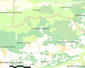
Витроль-ан-Люберон
- коммуна во Франции
Hiking in Витроль-ан-Люберон
Vitrolles-en-Luberon is a charming village located in the heart of the Luberon Regional Nature Park in Provence, France. The region is known for its stunning landscapes, rich biodiversity, and picturesque trails that cater to hikers of varying skill levels....
- Страна:
- Почтовый код: 84240
- Координаты: 43° 48' 40" N, 5° 35' 43" E
- GPS треки (wikiloc): [Ссылка]
- Площадь: 16.15 кв.км
- Население: 200


Сен-Мартен-де-Кастийон
- коммуна во Франции
Hiking in Сен-Мартен-де-Кастийон
Saint-Martin-de-Castillon is a charming village located in the Provence-Alpes-Côte d'Azur region of France, specifically in the Vaucluse department. Nestled in the heart of the Luberon Mountains, this area offers stunning landscapes, including vineyards, olive groves, and picturesque hillsides, making it a great destination for hiking enthusiasts. Here are some highlights:...
- Страна:
- Почтовый код: 84750
- Координаты: 43° 51' 34" N, 5° 30' 42" E
- GPS треки (wikiloc): [Ссылка]
- Площадь: 38.21 кв.км
- Население: 767


Вьян
- коммуна во Франции
Hiking in Вьян
Viens, located in the Vaucluse department of the Provence-Alpes-Côte d'Azur region in southern France, is a charming village surrounded by stunning natural landscapes, making it an excellent destination for hiking enthusiasts....
- Страна:
- Почтовый код: 84750
- Координаты: 43° 53' 42" N, 5° 34' 0" E
- GPS треки (wikiloc): [Ссылка]
- Площадь: 34.59 кв.км
- Население: 625
- Веб сайт: [Ссылка]