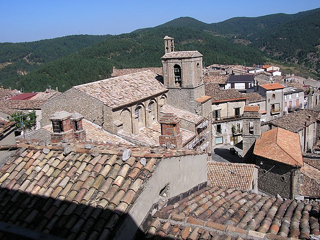
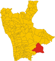
Каккури (Caccuri, Caccuri)
.svg)
- коммуна Италии
 Hiking in Каккури
Caccuri, a quaint town in the Calabria region of southern Italy, offers a unique hiking experience characterized by its scenic landscapes, historical landmarks, and rich biodiversity. Here are some details about hiking in and around Caccuri:
Hiking Trails
-
Monte Rireo: This mountain near Caccuri presents an opportunity for hikers to explore its diverse plant life and stunning panoramic views of the surrounding countryside and valleys. The trails range from moderate to challenging, making it suitable for various skill levels.
-
Ancient Pathways: Caccuri is surrounded by historical pathways that date back centuries. These trails often lead to ancient ruins and offer glimpses into the town's rich history, providing a cultural hiking experience.
-
Sila National Park: Although slightly farther from Caccuri, the Sila National Park is a must-visit for serious hikers. The park is known for its vast forests, lakes, and mountains, offering numerous trails for all difficulty levels.
What to Expect
-
Scenery: Hikers will enjoy beautiful views, including rolling hills, vineyards, and olive groves. The natural beauty of Calabria is captivating and can provide a peaceful escape.
-
Wildlife: The region is home to diverse flora and fauna, so be on the lookout for various bird species and other wildlife during your hikes.
-
Cultural Stops: Along your hiking routes, you'll find local towns and villages with historical sites, churches, and opportunities to taste local cuisine.
Tips for Hiking in Caccuri
-
Best Time to Go: The ideal months for hiking are typically from late spring to early autumn (May to October), when the weather is mild and trails are more accessible.
-
Gear Up: Ensure you wear appropriate hiking shoes, carry sufficient water, and have sun protection. Navigate with a map or a GPS device, especially if you're exploring less-marked trails.
-
Local Guidance: Consider hiring a local guide or joining a hiking group for a more enriching experience. They can provide insights into the local history, geology, and ecology.
Hiking in Caccuri provides an excellent blend of adventure, nature, and culture. Whether you are a seasoned hiker or a casual walker, you will surely find something to enjoy in this beautiful part of Italy.
- Страна:

- Почтовый код: 88833
- Телефонный код: 0984
- Код автомобильного номера: KR
- Координаты: 39° 14' 0" N, 16° 47' 0" E


- GPS треки (wikiloc): [Ссылка]
- Высота над уровнем моря: 646 м m
- Площадь: 61.38 кв.км
- Население: 1621
- Веб сайт: http://www.comune.caccuri.kr.it
- Википедия русская: wiki(ru)
- Википедия английская: wiki(en)
- Википедия национальная: wiki(it)
- Хранилище Wikidata: Wikidata: Q54496
- Галерея изображений в википедии: [Ссылка]
- Катеория в википедии: [Ссылка]
- код Freebase: [/m/0fjtkr]
- код GeoNames: Альт: [6539423]
- код VIAF: Альт: [245856436]
- ID отношения в OpenStreetMap: [39834]
- код GND: Альт: [4766626-2]
- код LCNAF: Альт: [no2010193659]
- код ISTAT: 101002
- кадастровый код Италии: B319
Граничит с регионами:
Сан-Джованни-ин-Фьоре
- коммуна Италии
Hiking in Сан-Джованни-ин-Фьоре
San Giovanni in Fiore, located in the Calabria region of southern Italy, is an excellent destination for hiking enthusiasts. Nestled in the Sila National Park, this area boasts stunning natural landscapes, diverse wildlife, and rich cultural heritage. Here are some key points to consider when planning your hiking trip in San Giovanni in Fiore:...
- Страна:
- Почтовый код: 87055
- Телефонный код: 0984
- Код автомобильного номера: CS
- Координаты: 39° 15' 51" N, 16° 42' 1" E
- GPS треки (wikiloc): [Ссылка]
- Высота над уровнем моря: 1049 м m
- Площадь: 279.45 кв.км
- Население: 17059
- Веб сайт: [Ссылка]


Кастельсилано
- коммуна Италии
Hiking in Кастельсилано
Castelsilano is a picturesque area in the Calabria region of southern Italy, known for its stunning landscapes, rich history, and diverse flora and fauna. While it may not be as famous as other hiking destinations in Italy, it offers a unique and serene hiking experience for those willing to explore its trails....
- Страна:
- Почтовый код: 88834
- Телефонный код: 0984
- Код автомобильного номера: KR
- Координаты: 39° 16' 0" N, 16° 46' 0" E
- GPS треки (wikiloc): [Ссылка]
- Высота над уровнем моря: 900 м m
- Площадь: 40.06 кв.км
- Население: 979
- Веб сайт: [Ссылка]


Черенция
- коммуна Италии
Hiking in Черенция
Cerenzia is a charming municipality located in the Calabria region of southern Italy, surrounded by picturesque landscapes and rich natural beauty. Hiking in Cerenzia offers a unique experience for outdoor enthusiasts, with various trails that cater to different skill levels....
- Страна:
- Почтовый код: 88833
- Телефонный код: 0984
- Код автомобильного номера: KR
- Координаты: 39° 15' 0" N, 16° 47' 0" E
- GPS треки (wikiloc): [Ссылка]
- Высота над уровнем моря: 900 м m
- Площадь: 21.97 кв.км
- Население: 1123
- Веб сайт: [Ссылка]


Котроней
- коммуна Италии
Hiking in Котроней
Cotronei, located in the Calabria region of southern Italy, is surrounded by the beautiful landscapes of the Sila National Park. This area offers a fantastic opportunity for hiking enthusiasts to explore its diverse terrain, with lush forests, rolling hills, and stunning mountain views....
- Страна:
- Почтовый код: 88836
- Телефонный код: 0962
- Код автомобильного номера: KR
- Координаты: 39° 10' 0" N, 16° 47' 0" E
- GPS треки (wikiloc): [Ссылка]
- Высота над уровнем моря: 502 м m
- Площадь: 79.2 кв.км
- Население: 5465
- Веб сайт: [Ссылка]
Роккабернарда
- коммуна Италии
Hiking in Роккабернарда
Roccabernarda is a charming town located in Calabria, Italy, known for its natural beauty and proximity to various hiking opportunities. The surrounding areas offer diverse landscapes, including rolling hills, mountainous terrains, and lush vegetation, making it a great destination for outdoor enthusiasts....
- Страна:
- Почтовый код: 88835
- Телефонный код: 0962
- Код автомобильного номера: KR
- Координаты: 39° 8' 0" N, 16° 52' 0" E
- GPS треки (wikiloc): [Ссылка]
- Высота над уровнем моря: 180 м m
- Площадь: 64.89 кв.км
- Население: 3374
- Веб сайт: [Ссылка]


Санто-Северина
- коммуна Италии
Hiking in Санто-Северина
Santa Severina is a charming town in the Calabria region of southern Italy, known for its historical architecture and scenic landscapes. While it may not be a prominent destination for hiking compared to some of the more well-known national parks in Italy, there are still opportunities for outdoor activities and exploration in and around the area....
- Страна:
- Почтовый код: 88832
- Телефонный код: 0962
- Код автомобильного номера: KR
- Координаты: 39° 9' 0" N, 16° 55' 0" E
- GPS треки (wikiloc): [Ссылка]
- Высота над уровнем моря: 350 м m
- Площадь: 52.31 кв.км
- Население: 2050
- Веб сайт: [Ссылка]