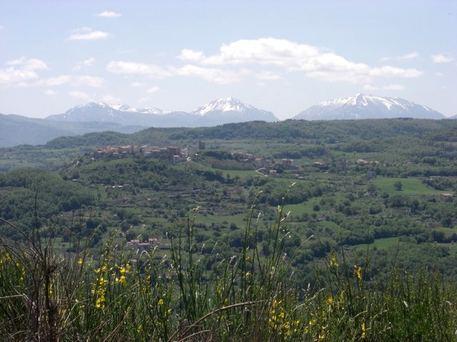
Кальвера (Calvera, Calvera)
.svg)
- коммуна Италии
 Hiking in Кальвера
Calavera, often referred to as Calavera Lake or the Calavera Nature Preserve, is a great place for hiking and exploring. Located near the town of Carlsbad in California, this area offers a blend of natural beauty, diverse ecosystems, and historical significance.
Hiking Trails
-
Calavera Lake Trail: This is one of the main trails in the area and offers a moderate hike around Calavera Lake. The trail is approximately 1.5 miles long and provides opportunities to see various local wildlife and plants.
-
Calavera Hills Loop: This loop is about 2 miles long and showcases beautiful vistas of the surrounding hills and landscape. It's a great choice for both families and solo hikers.
-
Calavera Preserve Loop: This is a more rugged trail that traverses through different terrains including some uphill sections. It’s suitable for those looking for a bit more challenge and time spent in nature.
Wildlife and Nature
The Calavera area is rich with wildlife. Hikers might see birds, small mammals, and various reptiles. The flora includes native plants such as coastal sage scrub, which provides a unique hiking experience through diverse ecosystems.
Safety Tips
- Always bring plenty of water, especially in warmer months.
- Wear sturdy footwear, as trails can be rocky and uneven.
- Keep an eye on the weather, and be prepared for sudden changes.
Accessibility
The trails in Calavera are generally well-marked and accessible for hikers of all skill levels, making it a popular destination for families, dog walkers, and more experienced hikers alike.
Other Considerations
- Be sure to check for any specific regulations regarding dogs, especially if you plan to hike with your pet.
- It’s advisable to leave no trace—pack out what you pack in to maintain the beauty of the area.
With its stunning views and variety of trails, Calavera is a fantastic hiking destination for those looking to explore the natural beauty of Southern California. Enjoy your hike!
- Страна:

- Почтовый код: 85030
- Телефонный код: 0973
- Код автомобильного номера: PZ
- Координаты: 40° 9' 0" N, 16° 9' 0" E


- GPS треки (wikiloc): [Ссылка]
- Высота над уровнем моря: 630 м m
- Площадь: 16.01 кв.км
- Население: 384
- Веб сайт: http://www.calveraweb.it/
- Википедия русская: wiki(ru)
- Википедия английская: wiki(en)
- Википедия национальная: wiki(it)
- Хранилище Wikidata: Wikidata: Q52545
- Катеория в википедии: [Ссылка]
- код Freebase: [/m/0cs78w]
- код GeoNames: Альт: [6537610]
- ID отношения в OpenStreetMap: [40308]
- место в MusicBrainz: [29100589-f365-45df-a057-da6943585705]
- код ISTAT: 076016
- кадастровый код Италии: B443
Граничит с регионами:
Карбоне
- коммуна Италии
Hiking in Карбоне
Hiking in Carbone, a small town in the Basilicata region of southern Italy, offers a unique experience surrounded by stunning landscapes, rich history, and a peaceful atmosphere. Here are some highlights of hiking in this area:...
- Страна:
- Почтовый код: 85030
- Телефонный код: 0973
- Код автомобильного номера: PZ
- Координаты: 40° 8' 0" N, 16° 5' 0" E
- GPS треки (wikiloc): [Ссылка]
- Высота над уровнем моря: 690 м m
- Площадь: 48.53 кв.км
- Население: 608
- Веб сайт: [Ссылка]
Кастронуово-ди-Сант'Андреа
- коммуна Италии
Hiking in Кастронуово-ди-Сант'Андреа
Castronuovo di Sant'Andrea is a small village located in the Basilicata region of southern Italy, surrounded by the picturesque Apennine Mountains. This area offers some beautiful hiking opportunities, with trails that showcase the natural beauty and rugged landscapes of the region....
- Страна:
- Почтовый код: 85030
- Телефонный код: 0973
- Код автомобильного номера: PZ
- Координаты: 40° 11' 0" N, 16° 11' 0" E
- GPS треки (wikiloc): [Ссылка]
- Высота над уровнем моря: 650 м m
- Площадь: 47.45 кв.км
- Население: 1016
- Веб сайт: [Ссылка]
Сан-Кирико-Рапаро
- коммуна Италии
Hiking in Сан-Кирико-Рапаро
San Chirico Raparo is a small town located in the Basilicata region of southern Italy. Nestled in the Apennine mountain range, it offers a unique blend of scenic beauty, cultural heritage, and opportunities for hiking enthusiasts. Here’s what you need to know about hiking in and around San Chirico Raparo:...
- Страна:
- Почтовый код: 85030
- Телефонный код: 0973
- Код автомобильного номера: PZ
- Координаты: 40° 11' 0" N, 16° 5' 0" E
- GPS треки (wikiloc): [Ссылка]
- Высота над уровнем моря: 780 м m
- Площадь: 84.07 кв.км
- Население: 1032
- Веб сайт: [Ссылка]

Теана
- коммуна Италии
Hiking in Теана
Teana, located in the region of Calabria in southern Italy, offers beautiful landscapes and a variety of hiking opportunities. The area is known for its natural beauty, featuring mountains, forests, and picturesque views of the surrounding valleys and the Tyrrhenian Sea. Here are some key points to consider when hiking in Teana:...
- Страна:
- Почтовый код: 85030
- Телефонный код: 0973
- Код автомобильного номера: PZ
- Координаты: 40° 7' 40" N, 16° 9' 19" E
- GPS треки (wikiloc): [Ссылка]
- Высота над уровнем моря: 806 м m
- Площадь: 19.3 кв.км
- Население: 585
- Веб сайт: [Ссылка]