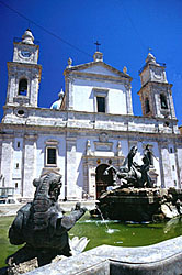
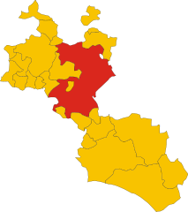
Каникатти (Canicattì, Canicattì)
- коммуна Италии
Canicattì, located in the southern part of Sicily, Italy, offers a unique landscape for hikers, with its rolling hills, rocky terrain, and rich cultural history. While it may not be as famous for hiking as some of the larger Sicilian destinations like Mount Etna or the Madonie Mountains, it does provide opportunities for outdoor enthusiasts looking for a more off-the-beaten-path experience.
Hiking Highlights in Canicattì:
-
Natural Landscapes: The area around Canicattì features diverse ecosystems, including vineyards, olive groves, and Mediterranean scrub. The terrain can vary from gentle hills to more challenging rocky trails, making it suitable for hikers of all levels.
-
Cultural Exploration: Hiking near Canicattì allows you to not only enjoy the natural beauty but also to encounter historical and archaeological sites. You may find ancient ruins, old farms, and churches scattered along the trails.
-
Local Flora and Fauna: As you hike, you'll have the chance to see various plant species native to the Mediterranean region, alongside wildlife that includes birds, small mammals, and reptiles.
-
Agricultural Trails: Many routes pass through agricultural lands, offering a glimpse into the traditional farming practices of the region, particularly viticulture (grape cultivation) and olive farming.
-
Nearby Nature Reserves: While Canicattì itself may not have designated national parks, nearby areas such as the Riserva Naturale Orientata Monte Cammarata provide more structured trails and protected environments for hiking.
Tips for Hiking in Canicattì:
-
Best Time to Hike: Spring (March to May) and fall (September to November) are ideal times for hiking, as temperatures are more pleasant, and the landscapes are typically lush and vibrant.
-
Prepare for Varied Terrain: While some trails may be easy, others can be rocky and steep. Wear appropriate footwear and carry plenty of water, especially during the hotter months.
-
Local Guidance: Consider hiring a local guide or joining hiking groups to help navigate trails and enrich your experience with knowledge about the area.
-
Respect Nature: Follow Leave No Trace principles. Be mindful of the natural vs. cultural heritage in the area, leaving trails and sites as you found them.
Overall, hiking in Canicattì offers a delightful combination of nature, culture, and adventure, perfect for those looking to explore the quieter side of Sicily.
- Страна:

- Почтовый код: 92024
- Телефонный код: 0922
- Код автомобильного номера: AG
- Координаты: 37° 21' 36" N, 13° 51' 4" E


- GPS треки (wikiloc): [Ссылка]
- Высота над уровнем моря: 465 м m
- Площадь: 91.86 кв.км
- Население: 35722
- Веб сайт: http://www.comune.canicatti.ag.it/
- Википедия русская: wiki(ru)
- Википедия английская: wiki(en)
- Википедия национальная: wiki(it)
- Хранилище Wikidata: Wikidata: Q431418
- Галерея изображений в википедии: [Ссылка]
- Катеория в википедии: [Ссылка]
- код Freebase: [/m/0gqg0x]
- код GeoNames: Альт: [6539170]
- код VIAF: Альт: [157262068]
- ID отношения в OpenStreetMap: [39227]
- код GND: Альт: [4454370-0]
- место в MusicBrainz: [5bb4f6f3-5fb5-4a6d-a662-8f1097137d59]
- код темы Quora: [Canicattì]
- UN/LOCODE: [ITZEP]
- код Цифрового атласа Римской империи: [42135]
- код ISTAT: 084011
- кадастровый код Италии: B602
Граничит с регионами:


Кальтаниссетта
- коммуна в Италии
Caltanissetta, located in the heart of Sicily, is a region rich in natural beauty, historical significance, and diverse landscapes, making it an attractive destination for hikers. Here are some highlights about hiking in Caltanissetta:...
- Страна:

- Почтовый код: 93100
- Телефонный код: 0934
- Код автомобильного номера: CL
- Координаты: 37° 29' 25" N, 14° 3' 44" E


- GPS треки (wikiloc): [Ссылка]
- Высота над уровнем моря: 568 м m
- Площадь: 421.25 кв.км
- Население: 62317
- Веб сайт: [Ссылка]


Кастрофилиппо
- коммуна Италии
Castrofilippo, a charming municipality located in the province of Agrigento, Sicily, offers various opportunities for hiking enthusiasts to explore the beautiful Sicilian landscape. Here are some highlights and tips for hiking in the area:...
- Страна:

- Почтовый код: 92020
- Телефонный код: 0922
- Код автомобильного номера: AG
- Координаты: 37° 21' 0" N, 13° 45' 4" E


- GPS треки (wikiloc): [Ссылка]
- Высота над уровнем моря: 470 м m
- Площадь: 18.08 кв.км
- Население: 2912
- Веб сайт: [Ссылка]


Равануза
- коммуна Италии
Ravanusa, a small town in Sicily, Italy, is not widely recognized as a traditional hiking destination. However, the surrounding region offers beautiful landscapes and opportunities for hiking enthusiasts. Here are some things to consider when hiking around Ravanusa:...
- Страна:

- Почтовый код: 92029
- Телефонный код: 0922
- Код автомобильного номера: AG
- Координаты: 37° 16' 4" N, 13° 58' 11" E


- GPS треки (wikiloc): [Ссылка]
- Высота над уровнем моря: 320 м m
- Площадь: 49.5 кв.км
- Население: 11471
- Веб сайт: [Ссылка]


Кампобелло-ди-Ликата
- коммуна Италии
 Hiking in Кампобелло-ди-Ликата
Campobello di Licata, located in the province of Agrigento in Sicily, Italy, offers a mix of natural beauty and cultural heritage, making it a unique destination for hiking enthusiasts. Here are some highlights and tips for hiking in and around Campobello di Licata:...
- Страна:

- Почтовый код: 92023
- Телефонный код: 0922
- Код автомобильного номера: AG
- Координаты: 37° 15' 34" N, 13° 55' 9" E


- GPS треки (wikiloc): [Ссылка]
- Высота над уровнем моря: 316 м m
- Площадь: 81.33 кв.км
- Население: 9860
- Веб сайт: [Ссылка]


Наро
- коммуна Италии
Naro, being a less commonly mentioned location, may refer to several places. However, if you're referring to Naro, Italy, it is generally known for its scenic landscapes, historical sites, and various outdoor activities, including hiking. Here are some highlights about hiking in the area:...
- Страна:

- Почтовый код: 92028
- Телефонный код: 0922
- Код автомобильного номера: AG
- Координаты: 37° 17' 33" N, 13° 47' 36" E


- GPS треки (wikiloc): [Ссылка]
- Высота над уровнем моря: 600 м m
- Площадь: 207.49 кв.км
- Население: 7580
- Веб сайт: [Ссылка]


Ракальмуто
- коммуна Италии
Racalmuto, located in Sicily, Italy, is surrounded by beautiful landscapes that are ideal for hiking enthusiasts. The terrain in and around Racalmuto features a mix of rolling hills, vineyards, and orchards, providing a variety of trails that cater to different skill levels....
- Страна:

- Почтовый код: 92020
- Телефонный код: 0922
- Код автомобильного номера: AG
- Координаты: 37° 24' 30" N, 13° 44' 5" E


- GPS треки (wikiloc): [Ссылка]
- Высота над уровнем моря: 455 м m
- Площадь: 68.1 кв.км
- Население: 8155
- Веб сайт: [Ссылка]
Делья
- коммуна в Италии
Delia, a small town in the province of Caltanissetta in Sicily, is surrounded by beautiful landscapes that offer hiking opportunities for those looking to explore the natural beauty of the region. Here are some key points about hiking in and around Delia:...
- Страна:

- Почтовый код: 93010
- Телефонный код: 0922
- Код автомобильного номера: CL
- Координаты: 37° 21' 0" N, 13° 56' 0" E


- GPS треки (wikiloc): [Ссылка]
- Высота над уровнем моря: 420 м m
- Площадь: 12.4 кв.км
- Население: 4150
- Веб сайт: [Ссылка]

Монтедоро
- коммуна в Италии
Montedoro, located in Sicily, Italy, offers a range of hiking opportunities that cater to various skill levels and preferences. The landscape is characterized by rolling hills, olive groves, and scenic views of the surrounding countryside, providing a beautiful backdrop for outdoor activities....
- Страна:

- Почтовый код: 93010
- Телефонный код: 0934
- Код автомобильного номера: CL
- Координаты: 37° 27' 16" N, 13° 49' 1" E


- GPS треки (wikiloc): [Ссылка]
- Высота над уровнем моря: 450 м m
- Площадь: 14.53 кв.км
- Население: 1557
- Веб сайт: [Ссылка]


Серрадифалько
- коммуна в Италии
Serradifalco is a small town located in Sicily, Italy, known for its beautiful landscapes and rich history. Hiking in and around Serradifalco offers a wonderful opportunity to explore the natural beauty of the Sicilian countryside, along with its cultural heritage....
- Страна:

- Почтовый код: 93010
- Телефонный код: 0934
- Код автомобильного номера: CL
- Координаты: 37° 27' 14" N, 13° 52' 50" E


- GPS треки (wikiloc): [Ссылка]
- Высота над уровнем моря: 504 м m
- Площадь: 41.94 кв.км
- Население: 5959
- Веб сайт: [Ссылка]
