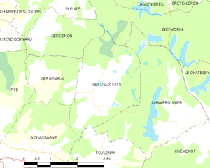
canton of Chaumergy (canton de Chaumergy)
 Hiking in canton of Chaumergy
Canton de Chaumergy, located in the Jura region of France, offers an array of scenic hiking opportunities. The area is known for its lush landscapes, rolling hills, forests, and picturesque villages, which provide a beautiful backdrop for outdoor enthusiasts.
Hiking Trails:
-
Variety of Trails: There are numerous marked trails catering to different skill levels, ranging from easy scenic walks to more challenging hikes for experienced hikers. The trails often take you through forests, alongside rivers, and over hills, allowing for varied terrain.
-
Natural Features: Hikers can enjoy natural features like the Jura mountain range, where you might encounter stunning views, rock formations, and diverse flora and fauna. The region is also home to numerous waterfalls and streams, adding to the charm of the hikes.
-
Historical Sites: Some trails might lead you to historical or cultural sites, such as ancient ruins or traditional villages, giving you a glimpse into the local history and culture as you hike.
Preparation Tips:
-
Trail Maps: It’s a good idea to have a detailed trail map or a hiking app that includes the local trails to help you navigate the area.
-
Seasonal Considerations: The best time to hike in Canton de Chaumergy is typically during late spring to early autumn (May to October), when the weather is generally more favorable. Always check the weather conditions before your hike.
-
Equipment: Ensure you have suitable hiking gear, including sturdy shoes, water, snacks, and possibly trekking poles if you’re taking on a more rigorous trail.
-
Stay Safe: Be aware of your physical limits, always inform someone of your hiking plans, and if you’re hiking in remote areas, consider going with a group or experienced guide.
Ecological Respect:
- Leave No Trace: Help preserve the natural beauty of the area by following the Leave No Trace principles; stay on marked trails, pack out what you bring in, and respect wildlife.
In summary, hiking in Canton de Chaumergy can be a rewarding and enriching experience, offering beautiful landscapes, varying difficulties, and an opportunity to connect with nature and history. Be sure to prepare adequately, respect the environment, and enjoy your adventure!
- Страна:

- Столица: Chaumergy
- Координаты: 46° 50' 39" N, 5° 28' 29" E


- GPS треки (wikiloc): [Ссылка]
- Хранилище Wikidata: Wikidata: Q1724892
- код кантона INSEE: [3907]
Включает регионы:


Chaumergy
- коммуна во Франции
Hiking in Chaumergy
Chaumergy, a small village in the Jura region of France, offers a unique hiking experience surrounded by natural beauty, rolling hills, and rich biodiversity. Although it’s lesser-known compared to some more popular hiking destinations, it attracts outdoor enthusiasts looking for tranquility and stunning landscapes....
- Страна:
- Почтовый код: 39230
- Координаты: 46° 50' 46" N, 5° 28' 40" E
- GPS треки (wikiloc): [Ссылка]
- Площадь: 6.14 кв.км
- Население: 481


La Chassagne
- коммуна во Франции
- Страна:
- Почтовый код: 39230
- Координаты: 46° 51' 49" N, 5° 27' 7" E
- GPS треки (wikiloc): [Ссылка]
- Площадь: 5.67 кв.км
- Население: 123

Les Deux-Fays
- коммуна во Франции
- Страна:
- Почтовый код: 39230
- Координаты: 46° 52' 56" N, 5° 28' 56" E
- GPS треки (wikiloc): [Ссылка]
- Площадь: 6.77 кв.км
- Население: 95


Rye
- Страна:
- Почтовый код: 39230
- Координаты: 46° 52' 15" N, 5° 25' 45" E
- GPS треки (wikiloc): [Ссылка]
- Площадь: 11.84 кв.км
- Население: 217


Froideville
- коммуна во Франции
Hiking in Froideville
Froideville, located in the Jura mountain range in Switzerland, offers a variety of hiking opportunities characterized by its stunning natural landscapes, diverse ecosystems, and picturesque views. Here are some details to keep in mind if you're planning to hike in this area:...
- Страна:
- Почтовый код: 39230
- Координаты: 46° 48' 35" N, 5° 29' 6" E
- GPS треки (wikiloc): [Ссылка]
- Площадь: 2.97 кв.км
- Население: 68


Francheville
Hiking in Francheville
Francheville in the Jura region of France is a delightful hiking destination that offers a variety of trails with stunning views, diverse landscapes, and rich flora and fauna. If you're planning to hike in this area, here are some key points to consider:...
- Страна:
- Почтовый код: 39230
- Координаты: 46° 50' 18" N, 5° 29' 57" E
- GPS треки (wikiloc): [Ссылка]
- Площадь: 1.46 кв.км
- Население: 47


Foulenay
- коммуна во Франции
- Страна:
- Почтовый код: 39230
- Координаты: 46° 51' 49" N, 5° 29' 7" E
- GPS треки (wikiloc): [Ссылка]
- Площадь: 4.16 кв.км
- Население: 84


Chêne-Sec
- коммуна во Франции
- Страна:
- Почтовый код: 39230
- Координаты: 46° 51' 2" N, 5° 26' 28" E
- GPS треки (wikiloc): [Ссылка]
- Площадь: 0.76 кв.км
- Население: 34


Bois-de-Gand
- коммуна во Франции
Hiking in Bois-de-Gand
Bois-de-Gand, or "Gand Forest," is a beautiful natural area in Belgium, known for its scenic trails and rich biodiversity. While it may not be as famous as some larger national parks, it offers a wonderful escape for hikers looking to enjoy lush greenery, peaceful surroundings, and a variety of flora and fauna....
- Страна:
- Почтовый код: 39230
- Координаты: 46° 49' 36" N, 5° 29' 59" E
- GPS треки (wikiloc): [Ссылка]
- Площадь: 3.25 кв.км
- Население: 57


Commenailles
- коммуна во Франции
Hiking in Commenailles
Commenailles, a small commune in the Jura department of France, is a picturesque location for hiking enthusiasts. The surrounding Jura Mountains offer a variety of trails that cater to different skill levels, from easy scenic walks to more challenging hikes....
- Страна:
- Почтовый код: 39140
- Координаты: 46° 48' 11" N, 5° 27' 7" E
- GPS треки (wikiloc): [Ссылка]
- Площадь: 21.52 кв.км
- Население: 848
- Веб сайт: [Ссылка]


Le Villey
- коммуна во Франции
Hiking in Le Villey
Le Villey is a beautiful area in France, often celebrated for its stunning natural landscapes and hiking opportunities. Here’s a quick overview of what to expect when hiking in Le Villey:...
- Страна:
- Почтовый код: 39230
- Координаты: 46° 50' 42" N, 5° 30' 28" E
- GPS треки (wikiloc): [Ссылка]
- Площадь: 3.57 кв.км
- Население: 86


Sergenaux
- коммуна во Франции
- Страна:
- Почтовый код: 39230
- Координаты: 46° 53' 12" N, 5° 27' 27" E
- GPS треки (wikiloc): [Ссылка]
- Площадь: 3.24 кв.км
- Население: 74


Sergenon
- коммуна во Франции
- Страна:
- Почтовый код: 39120
- Координаты: 46° 54' 14" N, 5° 27' 23" E
- GPS треки (wikiloc): [Ссылка]
- Площадь: 3.88 кв.км
- Население: 56


Recanoz
- коммуна во Франции
Hiking in Recanoz
It seems there might be a misspelling or confusion regarding "Recanoz." If you meant "Reconoz," or perhaps another specific location, please clarify. However, if you're referring to a general area known for hiking, I can provide basic tips and guidelines for hiking in mountainous or remote regions....
- Страна:
- Почтовый код: 39230
- Координаты: 46° 48' 26" N, 5° 30' 22" E
- GPS треки (wikiloc): [Ссылка]
- Площадь: 3.01 кв.км
- Население: 89


La Chaux-en-Bresse
- коммуна во Франции
Hiking in La Chaux-en-Bresse
La Chaux-en-Bresse is a charming commune located in the Jura region of France, known for its picturesque landscapes and outdoor recreational opportunities, including hiking. If you're planning to hike in this area, here are a few highlights and tips:...
- Страна:
- Почтовый код: 39230
- Координаты: 46° 49' 35" N, 5° 28' 49" E
- GPS треки (wikiloc): [Ссылка]
- Площадь: 2.05 кв.км
- Население: 37


Vincent
- коммуна во Франции
Hiking in Vincent
Vincent, located in the Jura mountain range of France, offers a fantastic setting for hiking enthusiasts. The Jura mountains are known for their stunning landscapes, dense forests, and diverse flora and fauna, providing a variety of trails suitable for different levels of hikers....
- Страна:
- Почтовый код: 39230
- Координаты: 46° 47' 6" N, 5° 29' 28" E
- GPS треки (wikiloc): [Ссылка]
- Площадь: 8.72 кв.км
- Население: 317