canton of Clairvaux-les-Lacs (canton de Clairvaux-les-Lacs)
 Hiking in canton of Clairvaux-les-Lacs
Canton de Clairvaux-les-Lacs, located in the Jura region of France, offers a stunning natural landscape ideal for hiking enthusiasts. Known for its picturesque lakes, lush forests, and rolling hills, this area provides a variety of trails suitable for different skill levels, from leisurely walks to more challenging treks.
Here are some highlights and recommendations for hiking in the area:
Trails:
-
Lac de Clairvaux: A popular loop trail around the lake, this path allows hikers to enjoy the scenery, observe local wildlife, and take in the breathtaking views of the surrounding landscape. The trail is relatively flat, making it accessible for families and casual hikers.
-
Les Cascades du Hérisson: A bit further from Clairvaux-les-Lacs, this hike showcases beautiful waterfalls and scenic viewpoints. The trail is moderately challenging, offering a wonderful opportunity to experience the region's natural beauty.
-
Mont de la Grosse Roche: For those looking for a more strenuous hike, the ascent to this viewpoint provides rewarding panoramic views over the Jura mountains and the nearby lakes. The trail involves some elevation gain, so be prepared for a workout.
Flora and Fauna:
Hikers can expect to encounter diverse flora and fauna along the trails. The region is rich in biodiversity, with many species of trees, plants, and wildlife. Keep an eye out for birds, deer, and other animals that inhabit the area.
Best Time to Hike:
The best time for hiking in Canton de Clairvaux-les-Lacs is during the spring (April to June) and fall (September to October) when the weather is mild, and the landscapes are especially vibrant. Summer can be warm, while winter brings snow, which may limit access to some trails.
Preparation:
- Gear: Ensure you have sturdy hiking boots, appropriate clothing for the weather, and enough water and snacks.
- Maps: While many trails are marked, having a map or trail app can be helpful, especially for less well-known paths.
- Safety: Always let someone know your hiking plans, and consider checking the weather before heading out.
Local Amenities:
After a day on the trails, you can enjoy local cuisine in Clairvaux-les-Lacs, with several restaurants offering traditional Jura dishes. There are also opportunities for accommodation if you're planning an extended stay.
Hiking in Canton de Clairvaux-les-Lacs is a fantastic way to explore the natural beauty of the Jura region, and it offers a range of experiences for hikers of all levels. Enjoy your adventure!
- Страна:

- Столица: Clairvaux-les-Lacs
- Координаты: 46° 33' 52" N, 5° 45' 17" E


- GPS треки (wikiloc): [Ссылка]
- Хранилище Wikidata: Wikidata: Q1724969
- код кантона INSEE: [3910]
Включает регионы:

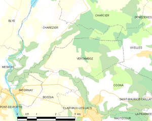
Vertamboz
- коммуна во Франции
Hiking in Vertamboz
Vertamboz, located in the Ain department in the Auvergne-Rhône-Alpes region of France, is a beautiful destination for hiking enthusiasts. While it may not be as widely recognized as some of the more famous hiking areas in France, it offers stunning landscapes and a chance to immerse yourself in nature....
- Страна:
- Почтовый код: 39130
- Координаты: 46° 35' 45" N, 5° 44' 29" E
- GPS треки (wikiloc): [Ссылка]
- Площадь: 6.66 кв.км
- Население: 90


Largillay-Marsonnay
- коммуна во Франции
Hiking in Largillay-Marsonnay
Largillay-Marsonnay, a small commune located in the Jura department in France, is a picturesque destination for hiking enthusiasts. The area offers beautiful landscapes characterized by rolling hills, dense forests, and charming rural vistas. Here are some key points to consider if you're planning a hiking trip in Largillay-Marsonnay:...
- Страна:
- Почтовый код: 39130
- Координаты: 46° 33' 16" N, 5° 40' 31" E
- GPS треки (wikiloc): [Ссылка]
- Площадь: 6.98 кв.км
- Население: 173


Mesnois
- коммуна во Франции
Hiking in Mesnois
Mesnois is a small commune in the Aube department in the Grand Est region of France. While it's not a well-known hiking destination like some of France’s larger national parks or mountainous areas, it does offer a glimpse of the picturesque rural landscape of the region....
- Страна:
- Почтовый код: 39130
- Координаты: 46° 36' 4" N, 5° 41' 23" E
- GPS треки (wikiloc): [Ссылка]
- Площадь: 11.47 кв.км
- Население: 194


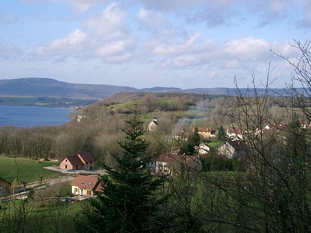
Clairvaux-les-Lacs
- коммуна во Франции
Hiking in Clairvaux-les-Lacs
Clairvaux-les-Lacs is a picturesque commune located in the Jura department in eastern France, known for its beautiful landscapes, lakes, and abundant nature. The region is a great destination for hiking enthusiasts, offering a variety of trails that cater to different skill levels and preferences....
- Страна:
- Почтовый код: 39130
- Координаты: 46° 34' 30" N, 5° 44' 57" E
- GPS треки (wikiloc): [Ссылка]
- Высота над уровнем моря: 541 м m
- Площадь: 12.29 кв.км
- Население: 1438
- Веб сайт: [Ссылка]


Patornay
- коммуна во Франции
Hiking in Patornay
Patornay is a small village located in the Jura region of France, known for its stunning natural landscapes, scenic trails, and outdoor recreational opportunities. Hiking in and around Patornay offers a chance to explore the beautiful Jura mountains, characterized by rolling hills, lush forests, and picturesque views....
- Страна:
- Почтовый код: 39130
- Координаты: 46° 35' 11" N, 5° 42' 15" E
- GPS треки (wikiloc): [Ссылка]
- Площадь: 1.8 кв.км
- Население: 140


Soucia
- коммуна во Франции
Hiking in Soucia
It seems there may be a bit of confusion with the name "Soucia." There is no widely recognized hiking destination or park by that name as of my last update in October 2023. However, if you meant a specific location or area—perhaps a region known for outdoor activities—I'd be happy to provide information about popular hiking destinations around the world, or specific areas you might be interested in....
- Страна:
- Почтовый код: 39130
- Координаты: 46° 32' 31" N, 5° 44' 57" E
- GPS треки (wikiloc): [Ссылка]
- Площадь: 12.37 кв.км
- Население: 189


Charcier
- коммуна во Франции
Hiking in Charcier
Charcier is a charming destination for hiking enthusiasts, particularly for those who enjoy exploring natural landscapes and discovering quaint villages. Nestled in the scenic regions, hiking in Charcier offers various trails that cater to different skill levels, making it suitable for both beginners and seasoned hikers....
- Страна:
- Почтовый код: 39130
- Координаты: 46° 37' 38" N, 5° 45' 3" E
- GPS треки (wikiloc): [Ссылка]
- Высота над уровнем моря: 525 м m
- Площадь: 12.91 кв.км
- Население: 116


Marigny
Hiking in Marigny
Hiking in the Marigny region of the Jura Mountains offers a unique opportunity to experience stunning landscapes, rich biodiversity, and picturesque villages. Located in eastern France, the Jura is characterized by its rolling hills, ridges, deep valleys, and beautiful lakes....
- Страна:
- Почтовый код: 39130
- Координаты: 46° 40' 55" N, 5° 47' 0" E
- GPS треки (wikiloc): [Ссылка]
- Площадь: 11.99 кв.км
- Население: 192


Le Frasnois
- коммуна во Франции
Hiking in Le Frasnois
Le Frasnois is a beautiful area located within the Jura region of France, known for its lush landscapes, stunning lakes, and diverse hiking trails. Here are some highlights and tips for hiking in Le Frasnois:...
- Страна:
- Почтовый код: 39130
- Координаты: 46° 38' 8" N, 5° 53' 51" E
- GPS треки (wikiloc): [Ссылка]
- Площадь: 14.56 кв.км
- Население: 155


Chevrotaine
- коммуна во Франции
Hiking in Chevrotaine
Chevrotaine, nestled in beautiful landscapes, offers a variety of hiking trails suitable for all levels of hikers. Here are some key points to consider when planning a hike there:...
- Страна:
- Почтовый код: 39130
- Координаты: 46° 39' 25" N, 5° 51' 10" E
- GPS треки (wikiloc): [Ссылка]
- Площадь: 5.33 кв.км
- Население: 33


La Frasnée
- коммуна во Франции
Hiking in La Frasnée
La Frasnée is known for its beautiful natural landscapes and hiking opportunities, situated within the picturesque region of the French Ardennes. This area is characterized by dense forests, rolling hills, and meandering rivers, providing a variety of terrains for hikers to explore....
- Страна:
- Почтовый код: 39130
- Координаты: 46° 33' 24" N, 5° 48' 39" E
- GPS треки (wikiloc): [Ссылка]
- Площадь: 3.19 кв.км
- Население: 37


Doucier
- коммуна во Франции
Hiking in Doucier
Doucier is a picturesque village located in the Jura region of France, known for its stunning natural landscapes and outdoor activities, including hiking. The area offers a variety of trails that cater to different skill levels, from easy walks to more challenging hikes....
- Страна:
- Почтовый код: 39130
- Координаты: 46° 39' 17" N, 5° 46' 44" E
- GPS треки (wikiloc): [Ссылка]
- Площадь: 12.52 кв.км
- Население: 305


Hautecour
- коммуна во Франции
Hiking in Hautecour
Hautecour, located in the Jura Mountains of France, is a beautiful destination for hiking enthusiasts seeking a mix of serene landscapes, lush forests, and panoramic views. The Jura region is known for its diverse terrain that includes rolling hills, deep valleys, and more rugged areas, providing trails suitable for all levels of hikers....
- Страна:
- Почтовый код: 39130
- Координаты: 46° 34' 6" N, 5° 45' 56" E
- GPS треки (wikiloc): [Ссылка]
- Площадь: 5.19 кв.км
- Население: 190


Charézier
- коммуна во Франции
Hiking in Charézier
Charézier is a small area in France, often known for its beautiful landscapes and outdoor activities, including hiking. While specific trails may vary based on seasonal conditions and maintenance, here are some general tips and insights about hiking in the Charézier region:...
- Страна:
- Почтовый код: 39130
- Координаты: 46° 36' 39" N, 5° 43' 39" E
- GPS треки (wikiloc): [Ссылка]
- Площадь: 9.26 кв.км
- Население: 166


Barésia-sur-l'Ain
- коммуна во Франции
Hiking in Barésia-sur-l'Ain
Barésia-sur-l'Ain is a picturesque commune located in the Ain department of the Auvergne-Rhône-Alpes region in France. It offers a charming rural setting that is conducive to hiking and outdoor activities....
- Страна:
- Почтовый код: 39130
- Координаты: 46° 32' 57" N, 5° 42' 41" E
- GPS треки (wikiloc): [Ссылка]
- Площадь: 9.39 кв.км
- Население: 157


Cogna
- коммуна во Франции
Hiking in Cogna
Cogna, located in the heart of the Alps, offers a variety of hiking opportunities suitable for all skill levels. The region is characterized by its stunning landscapes, including majestic mountains, lush valleys, and pristine lakes. Here are some key highlights for hiking in Cogna:...
- Страна:
- Почтовый код: 39130
- Координаты: 46° 34' 51" N, 5° 45' 28" E
- GPS треки (wikiloc): [Ссылка]
- Площадь: 6.6 кв.км
- Население: 253

Fontenu
- коммуна во Франции
Hiking in Fontenu
Fontenu is a beautiful destination located in the Jura region of France. The area is known for its stunning natural landscapes, including rolling hills, lush forests, and numerous lakes. Hiking in Fontenu offers a range of trails suited for various skill levels, from leisurely walks to more challenging hikes....
- Страна:
- Почтовый код: 39130
- Координаты: 46° 40' 5" N, 5° 49' 20" E
- GPS треки (wikiloc): [Ссылка]
- Площадь: 6.71 кв.км
- Население: 74


Saffloz
- коммуна во Франции
Hiking in Saffloz
Saffloz is not widely known as a hiking destination, and information may be limited. However, if you are referring to a specific region or place that may have alternative or local names, please provide more details....
- Страна:
- Почтовый код: 39130
- Координаты: 46° 40' 9" N, 5° 50' 53" E
- GPS треки (wikiloc): [Ссылка]
- Площадь: 8.65 кв.км
- Население: 108


Menétrux-en-Joux
- коммуна во Франции
Hiking in Menétrux-en-Joux
Menétrux-en-Joux is a charming village located in the Jura region of France, known for its beautiful natural landscapes that make it an excellent destination for hiking enthusiasts. The area is characterized by rolling hills, dense forests, and scenic viewpoints, offering a variety of hiking trails suitable for different skill levels....
- Страна:
- Почтовый код: 39130
- Координаты: 46° 37' 27" N, 5° 49' 43" E
- GPS треки (wikiloc): [Ссылка]
- Площадь: 8.78 кв.км
- Население: 58


Uxelles
- коммуна во Франции
Hiking in Uxelles
Uxelles is a charming commune in the Jura department of France, known for its scenic landscapes and outdoor activities, including hiking. Here are some highlights and tips for hiking in the Uxelles area:...
- Страна:
- Почтовый код: 39130
- Координаты: 46° 36' 10" N, 5° 47' 29" E
- GPS треки (wikiloc): [Ссылка]
- Площадь: 5.27 кв.км
- Население: 52


Thoiria
- коммуна во Франции
Hiking in Thoiria
Thoiria, a picturesque region often associated with breathtaking landscapes and a network of trails, offers hikers a variety of experiences ranging from easy walks to more challenging treks. Here are some highlights to consider if you're planning a hiking trip there:...
- Страна:
- Почтовый код: 39130
- Координаты: 46° 32' 1" N, 5° 44' 11" E
- GPS треки (wikiloc): [Ссылка]
- Площадь: 12.24 кв.км
- Население: 205


Pont-de-Poitte
- коммуна во Франции
Hiking in Pont-de-Poitte
Pont-de-Poitte is a charming village located in the Jura region of France, known for its beautiful landscapes, lakes, and outdoor recreational opportunities, making it an excellent base for hiking enthusiasts. Here’s what you need to know about hiking in the area:...
- Страна:
- Почтовый код: 39130
- Координаты: 46° 35' 1" N, 5° 41' 42" E
- GPS треки (wikiloc): [Ссылка]
- Площадь: 7.02 кв.км
- Население: 652


Songeson
- коммуна во Франции
Hiking in Songeson
It seems there may be a typo or misunderstanding in the name "Songeson," as it’s not a widely recognized hiking destination. However, if you're referring to a specific location that has a similar name, please clarify!...
- Страна:
- Почтовый код: 39130
- Координаты: 46° 39' 3" N, 5° 49' 13" E
- GPS треки (wikiloc): [Ссылка]
- Площадь: 8.42 кв.км
- Население: 72

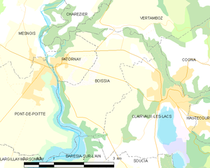
Boissia
- коммуна во Франции
Hiking in Boissia
Boissia, a small town located in the Val d'Aosta region of Italy, offers a range of hiking opportunities that cater to various skill levels. The surrounding mountains and natural landscapes provide stunning views, rich biodiversity, and a chance to explore the region’s beautiful alpine terrain....
- Страна:
- Почтовый код: 39130
- Координаты: 46° 35' 33" N, 5° 44' 5" E
- GPS треки (wikiloc): [Ссылка]
- Высота над уровнем моря: 484 м m
- Площадь: 5.67 кв.км
- Население: 129