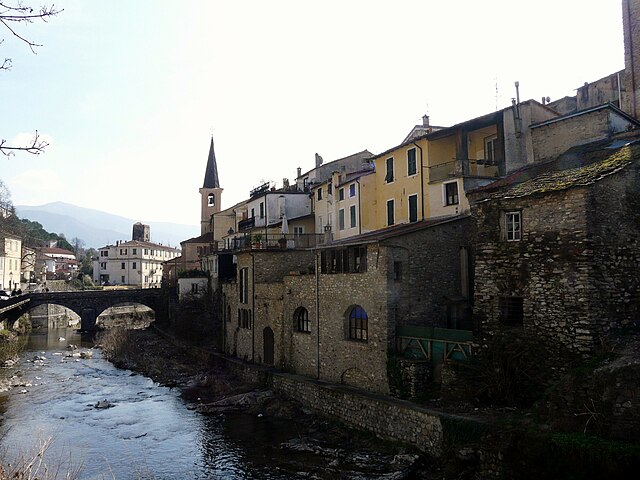
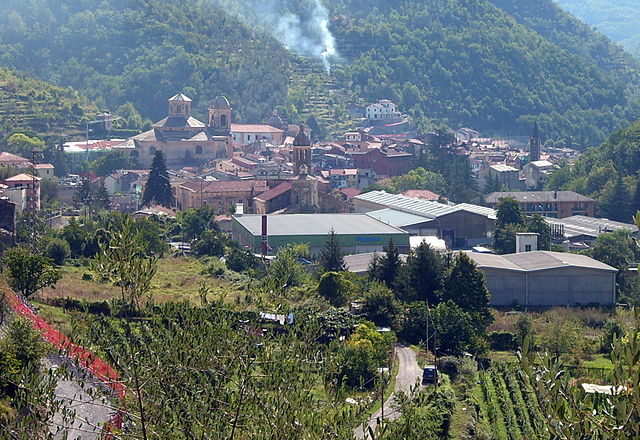
Каравоника (Caravonica, Caravonica)
.svg)
- коммуна Италии
 Hiking in Каравоника
Caravonica, located in Queensland, Australia, is a charming area near Cairns that offers various hiking opportunities, particularly in the surrounding natural landscapes. Here are some key points to consider for hiking in Caravonica:
1.
- Barron Gorge National Park: This park is close to Caravonica and features several scenic trails. The walks here take you through lush rainforest and offer stunning views of the Barron River and waterfalls. The Stoney Creek Walk and Barron Falls Walk are popular routes.
- Kuranda Scenic Railway: While not a hike in the traditional sense, many hikers enjoy combining a train ride with the surrounding nature trails once they arrive in Kuranda.
2.
- The trails in the area vary in difficulty, making them suitable for both beginners and experienced hikers. Always check trail markers and signage to ensure you're on the right path for your skill level.
3.
- Weather: Tropical weather can be unpredictable. Be sure to check the forecast before your hike and prepare for sudden rain.
- Gear: Wear comfortable hiking boots with good traction, and bring plenty of water, snacks, and sun protection (like hats and sunscreen).
- Wildlife: Keep an eye out for local wildlife, but be cautious. While many animals are harmless, it's best to observe them from a distance.
4.
- Inform someone of your hiking plans and expected return time.
- Stay on marked trails to preserve the environment and for your safety.
5.
- After your hike, consider visiting attractions in the Cairns region, including waterfalls, Kuranda markets, and the Daintree Rainforest.
6.
- There are local hiking groups and guided tours that can enhance your experience, especially if you're unfamiliar with the area.
Hiking in Caravonica and the surrounding regions can be an enjoyable experience, allowing you to immerse yourself in Queensland’s natural beauty. Always prioritize safety and environmental respect during your adventures!
- Страна:

- Почтовый код: 18020
- Телефонный код: 0183
- Код автомобильного номера: IM
- Координаты: 43° 59' 32" N, 7° 57' 31" E


- GPS треки (wikiloc): [Ссылка]
- Высота над уровнем моря: 360 м m
- Площадь: 4.47 кв.км
- Население: 266
- Веб сайт: http://www.comune.caravonica.im.it
- Википедия русская: wiki(ru)
- Википедия английская: wiki(en)
- Википедия национальная: wiki(it)
- Хранилище Wikidata: Wikidata: Q268279
- Катеория в википедии: [Ссылка]
- код Freebase: [/m/0gbybd]
- код GeoNames: Альт: [6540142]
- ID отношения в OpenStreetMap: [42794]
- UN/LOCODE: [ITVOX]
- код ISTAT: 008012
- кадастровый код Италии: B734
Граничит с регионами:

Боргомаро
- коммуна Италии
Hiking in Боргомаро
Borgomaro is a picturesque village located in the Liguria region of Italy, nestled in the foothills of the Maritime Alps. The area offers beautiful hiking opportunities, featuring lush landscapes, charming villages, and stunning views of the surrounding mountains and valleys....
- Страна:
- Почтовый код: 18021
- Телефонный код: 0183
- Код автомобильного номера: IM
- Координаты: 43° 58' 32" N, 7° 56' 41" E
- GPS треки (wikiloc): [Ссылка]
- Высота над уровнем моря: 200 м m
- Площадь: 23.44 кв.км
- Население: 881
- Веб сайт: [Ссылка]


Чезио
- коммуна Италии
Hiking in Чезио
Cesio is a small town located in the Liguria region of Italy, nestled in the Val Nervia valley. It offers several hiking opportunities that showcase the stunning natural beauty of the surrounding area, characterized by lush landscapes, hills, and proximity to the Mediterranean coast....
- Страна:
- Почтовый код: 18022
- Телефонный код: 0183
- Код автомобильного номера: IM
- Координаты: 44° 0' 29" N, 7° 58' 32" E
- GPS треки (wikiloc): [Ссылка]
- Высота над уровнем моря: 512 м m
- Площадь: 8.86 кв.км
- Население: 283
- Веб сайт: [Ссылка]


Кьюзанико
- коммуна Италии
Hiking in Кьюзанико
Chiusanico is a picturesque village located in the Liguria region of Italy, near the stunning coastline of the Italian Riviera. The area offers various hiking opportunities that cater to different skill levels, with trails that showcase the natural beauty of the region, including hills, vineyards, olive groves, and breathtaking views of the Ligurian Sea....
- Страна:
- Почтовый код: 18027
- Телефонный код: 0183
- Код автомобильного номера: IM
- Координаты: 43° 58' 16" N, 7° 59' 36" E
- GPS треки (wikiloc): [Ссылка]
- Высота над уровнем моря: 380 м m
- Площадь: 13.51 кв.км
- Население: 578
- Веб сайт: [Ссылка]

Пьеве-ди-Теко
- коммуна Италии
Hiking in Пьеве-ди-Теко
Pieve di Teco, located in the region of Liguria in northern Italy, offers a picturesque setting for hiking enthusiasts. This charming village, nestled in the Valle Arroscia, is surrounded by stunning landscapes, including rolling hills, terraced vineyards, and lush woodlands....
- Страна:
- Почтовый код: 18026
- Телефонный код: 0183
- Код автомобильного номера: IM
- Координаты: 44° 2' 53" N, 7° 54' 58" E
- GPS треки (wikiloc): [Ссылка]
- Высота над уровнем моря: 240 м m
- Площадь: 40.51 кв.км
- Население: 1339
- Веб сайт: [Ссылка]