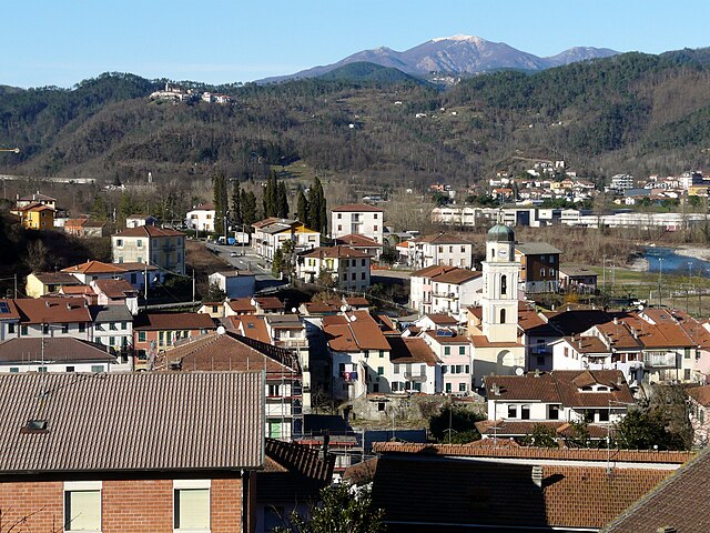
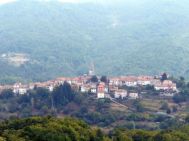
Карродано (Carrodano, Carrodano)
.svg)
- коммуна Италии
 Hiking in Карродано
Carrodano is a charming municipality located in the Liguria region of Italy, nestled in the picturesque landscape of the Italian Riviera. It offers a variety of hiking opportunities, showcasing lush forests, stunning views, and the rich biodiversity of the area. Here are some key points to consider if you want to hike in Carrodano:
Trails and Routes
-
Natural Parks: Carrodano is near the Cinque Terre National Park and the Montemarcello-Magra Regional Park. While not directly within Carrodano, these parks are easily accessible and offer numerous trails with breathtaking coastal views.
-
Local Trails: There are several local trails that connect Carrodano with nearby villages and towns, often through vineyards and olive groves. These paths can lead you to scenic overlooks and historical sites.
-
Difficulty Levels: The area has trails of varying difficulty, suitable for both beginners and experienced hikers. Make sure to check the trail difficulty before setting out.
Flora and Fauna
- The area is home to diverse ecosystems. Hikers can expect to see a mix of Mediterranean vegetation, including chestnut trees, oaks, and various wildflowers. Wildlife may include birds, deer, and other small animals.
Recommendations
-
Best Time to Hike: Spring and early autumn are generally the best times to hike in this region. The weather is milder, and the landscapes are particularly beautiful with blooming flowers and vibrant autumn colors.
-
Guided Tours: If you're unfamiliar with the area, consider booking a guided hiking tour. Local guides can provide insights into the area’s natural and cultural history, ensuring you get the most out of your experience.
-
Gear: Wear sturdy hiking shoes, carry enough water, and pack snacks. It's also advisable to bring a map or a GPS device, as some trails may not be well-marked.
-
Respect Nature: Remember to follow Leave No Trace principles to preserve the natural beauty of the area. Stay on designated trails and be mindful of local wildlife.
-
Cultural Aspects: Explore local villages for a taste of Ligurian culture and cuisine. Don’t miss out on trying regional specialties, such as pesto and focaccia, after a day of hiking.
Accessibility
Carrodano is easily reached by road and is also accessible from nearby towns like La Spezia and Levanto, making it a convenient base for your hiking adventures.
Overall, hiking in Carrodano can be a delightful experience, offering both natural beauty and cultural richness. Enjoy your exploration of this beautiful corner of Italy!
- Страна:

- Почтовый код: 19020
- Телефонный код: 0187
- Код автомобильного номера: SP
- Координаты: 44° 14' 31" N, 9° 39' 22" E


- GPS треки (wikiloc): [Ссылка]
- Высота над уровнем моря: 215 м m
- Площадь: 21.86 кв.км
- Население: 488
- Веб сайт: http://www.comune.carrodano.sp.it/
- Википедия русская: wiki(ru)
- Википедия английская: wiki(en)
- Википедия национальная: wiki(it)
- Хранилище Wikidata: Wikidata: Q201412
- Катеория в википедии: [Ссылка]
- код Freebase: [/m/0ghx80]
- код GeoNames: Альт: [3180410]
- ID отношения в OpenStreetMap: [42960]
- код ISTAT: 011010
- кадастровый код Италии: B839
Граничит с регионами:


Леванто
- коммуна Италии
Hiking in Леванто
Levanto, located on the beautiful Italian Riviera in Liguria, is a fantastic destination for hiking enthusiasts. Nestled between the Mediterranean Sea and the rugged hills, Levanto serves as a gateway to both the Cinque Terre National Park and the surrounding coastal trails. Here are some highlights about hiking in and around Levanto:...
- Страна:
- Почтовый код: 19015
- Телефонный код: 0187
- Код автомобильного номера: SP
- Координаты: 44° 10' 11" N, 9° 36' 44" E
- GPS треки (wikiloc): [Ссылка]
- Высота над уровнем моря: 3 м m
- Площадь: 36.81 кв.км
- Население: 5403
- Веб сайт: [Ссылка]

Боргетто-ди-Вара
- коммуна Италии
Hiking in Боргетто-ди-Вара
Borghetto di Vara is a picturesque village located in the Liguria region of Italy, nestled in the foothills of the Apennines, near the Cinque Terre. It offers stunning landscapes, rich history, and a variety of hiking opportunities for outdoor enthusiasts....
- Страна:
- Почтовый код: 19020
- Телефонный код: 0187
- Код автомобильного номера: SP
- Координаты: 44° 13' 26" N, 9° 43' 17" E
- GPS треки (wikiloc): [Ссылка]
- Высота над уровнем моря: 104 м m
- Площадь: 27.34 кв.км
- Население: 920
- Веб сайт: [Ссылка]

Карро
- коммуна Италии
Hiking in Карро
Carro, a charming town in the region of Liguria, Italy, is known for its stunning landscapes, rich history, and beautiful hiking trails. The area around Carro offers a variety of hiking opportunities suitable for different skill levels, and hikers can expect picturesque views of the surrounding hills, lush vegetation, and the nearby Mediterranean coastline....
- Страна:
- Почтовый код: 19012
- Телефонный код: 0187
- Код автомобильного номера: SP
- Координаты: 44° 16' 0" N, 9° 36' 0" E
- GPS треки (wikiloc): [Ссылка]
- Высота над уровнем моря: 418 м m
- Площадь: 31.79 кв.км
- Население: 528
- Веб сайт: [Ссылка]


Дейва-Марина
- коммуна Италии
Hiking in Дейва-Марина
Deiva Marina, located in the Liguria region of Italy, is a picturesque coastal town nestled between the hills and the Mediterranean Sea. It's a great starting point for hikers looking to explore the beautiful landscapes of the surrounding area. Here are some highlights and tips for hiking in and around Deiva Marina:...
- Страна:
- Почтовый код: 19013
- Телефонный код: 0187
- Код автомобильного номера: SP
- Координаты: 44° 13' 0" N, 9° 31' 0" E
- GPS треки (wikiloc): [Ссылка]
- Высота над уровнем моря: 18 м m
- Площадь: 14.09 кв.км
- Население: 1338
- Веб сайт: [Ссылка]


Фрамура
- коммуна Италии
Hiking in Фрамура
Framura is a stunning coastal village located in the Liguria region of Italy, situated between the famous Cinque Terre National Park and the Gulf of Poets. It offers a unique hiking experience, characterized by breathtaking views, charming villages, and diverse terrains....
- Страна:
- Почтовый код: 19014
- Телефонный код: 0187
- Код автомобильного номера: SP
- Координаты: 44° 12' 31" N, 9° 33' 16" E
- GPS треки (wikiloc): [Ссылка]
- Высота над уровнем моря: 76 м m
- Площадь: 19.26 кв.км
- Население: 653
- Веб сайт: [Ссылка]


Сеста-Годано
- коммуна Италии
Hiking in Сеста-Годано
Sesta Godano is a charming village located in the heart of the Ligurian region of Italy, surrounded by the beautiful landscapes of the Ligurian Apennines. It offers a variety of hiking opportunities for all levels, making it an excellent destination for outdoor enthusiasts....
- Страна:
- Почтовый код: 19020
- Телефонный код: 0187
- Код автомобильного номера: SP
- Координаты: 44° 17' 37" N, 9° 40' 32" E
- GPS треки (wikiloc): [Ссылка]
- Высота над уровнем моря: 242 м m
- Площадь: 67.78 кв.км
- Население: 1339
- Веб сайт: [Ссылка]