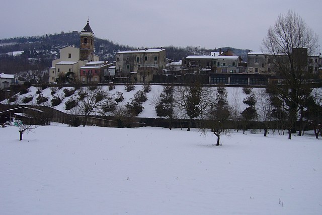
Казакандителла (Casacanditella, Casacanditella)
.svg)
- коммуна Италии
 Hiking in Казакандителла
Casacanditella, a charming village in the Abruzzo region of Italy, offers stunning natural landscapes, making it an excellent destination for hiking enthusiasts. Nestled in the foothills of the Apennines, the area is characterized by rolling hills, lush forests, and picturesque views.
Hiking Opportunities
-
Scenic Trails: The trails around Casacanditella vary from easy walks to more challenging hikes. Many paths provide views of the surrounding countryside, vineyards, and ancient olive groves.
-
Parco Nazionale della Majella: Located nearby, this national park is home to a vast network of trails. The park features dramatic landscapes, including rugged mountains, deep gorges, and a rich diversity of flora and fauna. Popular routes may lead to sites like the Gole di Fara San Martino or Monte Amaro.
-
Historical Routes: Some trails pass by historical sites, including old churches and ruins, adding a cultural aspect to your hiking experience.
Recommended Hiking Tips
- Safety First: Always let someone know your hiking plans, and consider carrying a map or using a GPS device to navigate the trails.
- Appropriate Gear: Wear proper hiking shoes, and bring water, snacks, sunscreen, and a first-aid kit.
- Best Time to Hike: Spring (April to June) and early fall (September to October) are ideal times for hiking in this region, as the weather is generally mild and the landscapes are vibrant.
Wildlife and Nature
The region is home to diverse wildlife, including deer, foxes, and various bird species. Pay attention to your surroundings, as you may spot unique plants and flowers, especially during the bloom in spring.
Local Culture
Don’t miss the chance to explore the village itself; enjoy local cuisine, including regional dishes made with fresh ingredients from the surrounding countryside.
In summary, hiking in and around Casacanditella offers a wonderful combination of natural beauty, outdoor adventures, and cultural experiences, making it worth a visit for any hiking enthusiast.
- Страна:

- Почтовый код: 66010
- Телефонный код: 0871
- Код автомобильного номера: CH
- Координаты: 42° 14' 51" N, 14° 12' 0" E


- GPS треки (wikiloc): [Ссылка]
- Высота над уровнем моря: 432 м m
- Площадь: 12.54 кв.км
- Население: 1262
- Веб сайт: http://www.comune.carpinetosinello.ch.it/
- Википедия русская: wiki(ru)
- Википедия английская: wiki(en)
- Википедия национальная: wiki(it)
- Хранилище Wikidata: Wikidata: Q51194
- Катеория в википедии: [Ссылка]
- код Freebase: [/m/0fg292]
- код GeoNames: Альт: [6537473]
- код VIAF: Альт: [235691260]
- ID отношения в OpenStreetMap: [41896]
- код ISTAT: 069013
- кадастровый код Италии: B859
Граничит с регионами:


Буккианико
- коммуна Италии
Hiking in Буккианико
Bucchianico is a charming town located in the Abruzzo region of Italy, known for its picturesque landscapes and historical significance. The surrounding area offers various hiking opportunities that cater to different levels of experience. Here are some highlights for hiking in and around Bucchianico:...
- Страна:
- Почтовый код: 66011
- Телефонный код: 0871
- Код автомобильного номера: CH
- Координаты: 42° 18' 16" N, 14° 10' 50" E
- GPS треки (wikiloc): [Ссылка]
- Высота над уровнем моря: 360 м m
- Площадь: 38.08 кв.км
- Население: 5126
- Веб сайт: [Ссылка]

Фара-Фильорум-Петри
- коммуна Италии
Hiking in Фара-Фильорум-Петри
Fara Filiorum Petri is a charming village located in the Abruzzo region of Italy, known for its picturesque landscapes and rich natural beauty. Hiking in and around Fara Filiorum Petri offers a range of trails that cater to different skill levels, allowing hikers to experience the stunning scenery typical of the Apennine Mountains....
- Страна:
- Почтовый код: 66010
- Телефонный код: 0871
- Код автомобильного номера: CH
- Координаты: 42° 14' 54" N, 14° 11' 9" E
- GPS треки (wikiloc): [Ссылка]
- Высота над уровнем моря: 227 м m
- Площадь: 14.96 кв.км
- Население: 1986
- Веб сайт: [Ссылка]
Филетто
- коммуна Италии
Hiking in Филетто
Filletto is a charming destination located in the Liguria region of Italy, known for its picturesque landscapes and outdoor activities. While the area isn't as widely known as some major hiking hotspots in Italy, it does offer some beautiful trails and opportunities for nature lovers....
- Страна:
- Почтовый код: 66030
- Телефонный код: 0871
- Код автомобильного номера: CH
- Координаты: 42° 13' 46" N, 14° 14' 42" E
- GPS треки (wikiloc): [Ссылка]
- Высота над уровнем моря: 403 м m
- Площадь: 13.53 кв.км
- Население: 918
- Веб сайт: [Ссылка]
Сан-Мартино-сулла-Марручина
- коммуна Италии
Hiking in Сан-Мартино-сулла-Марручина
San Martino sulla Marrucina, located in the Abruzzo region of Italy, offers beautiful hiking opportunities amidst stunning natural landscapes. The area is characterized by its rolling hills, lush forests, and panoramic views of the surrounding countryside, making it a great destination for both novice and experienced hikers....
- Страна:
- Почтовый код: 66010
- Телефонный код: 0871
- Код автомобильного номера: CH
- Координаты: 42° 13' 30" N, 14° 12' 52" E
- GPS треки (wikiloc): [Ссылка]
- Высота над уровнем моря: 420 м m
- Площадь: 7.41 кв.км
- Население: 920
- Веб сайт: [Ссылка]


Вакри
- коммуна Италии
Hiking in Вакри
Vacri is a charming village located in the Abruzzo region of Italy, offering a variety of stunning landscapes and opportunities for hiking enthusiasts. The area is characterized by its rolling hills, olive groves, and scenic views of the surrounding mountains....
- Страна:
- Почтовый код: 66010
- Телефонный код: 0871
- Код автомобильного номера: CH
- Координаты: 42° 17' 52" N, 14° 13' 58" E
- GPS треки (wikiloc): [Ссылка]
- Высота над уровнем моря: 310 м m
- Площадь: 12.27 кв.км
- Население: 1631
- Веб сайт: [Ссылка]