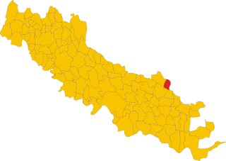
Казальромано (Casalromano, Casalromano)
.svg)
- коммуна Италии
 Hiking in Казальромано
Casalromano is a small village located in the Lombardy region of Italy, surrounded by beautiful landscapes that are great for hiking enthusiasts. While it may not be as well-known as larger towns or national parks, the area does offer some charming trails and scenic vistas that capture the essence of the Italian countryside.
Hiking Trails
-
Local Nature Trails: The immediate area around Casalromano features various paths and nature trails that allow you to explore the picturesque countryside. These trails often lead through fields, forests, and along rivers, providing an authentic Italian rural experience.
-
Monte Netto: A more challenging option nearby is Monte Netto, which offers steeper climbs and stunning views from its summit. The hike can be more strenuous, making it suitable for experienced hikers looking for a rewarding experience.
-
Riverside Walks: The region is also home to beautiful riverbanks, where you can enjoy leisurely walks while taking in the tranquillity of the flowing water. These paths are often easier and ideal for families or casual hikers.
Tips for Hiking in Casalromano
-
Best Time to Hike: The best time for hiking in this area is typically from spring to early autumn when the weather is pleasant and the landscapes are lush and vibrant.
-
Local Wildlife: Keep an eye out for local flora and fauna along the trails. The area may host a variety of bird species and small mammals.
-
Navigation: Although many trails are marked, carrying a map or using a GPS app is advisable, especially on less frequented paths.
-
Equipment: Wear sturdy hiking boots, and consider bringing trekking poles for added support on uneven terrain. It's also essential to carry plenty of water, snacks, and sunscreen.
-
Respect Nature: As with all hiking, it's important to respect nature. Stay on marked trails, pack out any trash, and be mindful of local wildlife.
Nearby Attractions
While in Casalromano, you may also want to explore nearby towns and attractions. The larger city of Cremona is not far and offers additional cultural experiences, including beautiful architecture and historical sites.
Overall, hiking in Casalromano can be a delightful way to experience the natural beauty of Lombardy, away from the crowds often found in more popular hiking destinations.
- Страна:

- Почтовый код: 46040
- Телефонный код: 0376
- Код автомобильного номера: MN
- Координаты: 45° 12' 0" N, 10° 22' 0" E


- GPS треки (wikiloc): [Ссылка]
- Высота над уровнем моря: 42 м m
- Площадь: 12.03 кв.км
- Население: 1510
- Веб сайт: http://www.comune.casalromano.mn.it
- Википедия русская: wiki(ru)
- Википедия английская: wiki(en)
- Википедия национальная: wiki(it)
- Хранилище Wikidata: Wikidata: Q42127
- Катеория в википедии: [Ссылка]
- код Freebase: [/m/0gj_tr]
- код GeoNames: Альт: [6536586]
- ID отношения в OpenStreetMap: [44433]
- UN/LOCODE: [ITZFU]
- код ISTAT: 020012
- кадастровый код Италии: B911
Граничит с регионами:

Фьессе
- коммуна Италии
Hiking in Фьессе
Fiesse is a small town located in the province of Brescia, Lombardy, Italy. While it may not be a well-known hiking destination compared to some of the larger national parks or regions in Italy, it is situated within a beautiful area that offers access to various hiking opportunities in the surrounding countryside and the larger Lombardy region....
- Страна:
- Почтовый код: 25020
- Телефонный код: 030
- Код автомобильного номера: BS
- Координаты: 45° 13' 57" N, 10° 19' 31" E
- GPS треки (wikiloc): [Ссылка]
- Высота над уровнем моря: 39 м m
- Площадь: 16.02 кв.км
- Население: 2041
- Веб сайт: [Ссылка]


Азола
- коммуна Италии
Hiking in Азола
Asola, located in the Lombardy region of Italy, offers various hiking opportunities that beautifully showcase the area's natural landscapes and cultural heritage. While it may not be as renowned as some of the bigger hiking destinations in Italy, it provides a more tranquil and less crowded experience for those who wish to explore the countryside....
- Страна:
- Почтовый код: 46041
- Телефонный код: 0376
- Код автомобильного номера: MN
- Координаты: 45° 13' 0" N, 10° 25' 0" E
- GPS треки (wikiloc): [Ссылка]
- Высота над уровнем моря: 42 м m
- Площадь: 73.48 кв.км
- Население: 10069
- Веб сайт: [Ссылка]


Каннето-сулл'Ольйо
- коммуна Италии
Hiking in Каннето-сулл'Ольйо
Canneto sull'Oglio is a charming town located in the Lombardy region of Italy, and while it may not be as well-known for hiking as some other Italian destinations, it offers scenic landscapes and opportunities for outdoor activities. Here are some tips and information for hiking in and around Canneto sull'Oglio:...
- Страна:
- Почтовый код: 46013
- Телефонный код: 0376
- Код автомобильного номера: MN
- Координаты: 45° 9' 0" N, 10° 23' 0" E
- GPS треки (wikiloc): [Ссылка]
- Высота над уровнем моря: 34 м m
- Площадь: 25.87 кв.км
- Население: 4388
- Веб сайт: [Ссылка]


Изола-Доварезе
- коммуна Италии
Hiking in Изола-Доварезе
Isola Dovarese is a charming village located in the province of Cremona in the Lombardy region of Italy. Surrounded by the picturesque landscape of the Po Valley, it offers a less-traveled yet beautiful hiking experience....
- Страна:
- Почтовый код: 26031
- Телефонный код: 0375
- Код автомобильного номера: CR
- Координаты: 45° 10' 33" N, 10° 18' 44" E
- GPS треки (wikiloc): [Ссылка]
- Высота над уровнем моря: 35 м m
- Площадь: 9.47 кв.км
- Население: 1158
- Веб сайт: [Ссылка]

Волонго
- коммуна Италии
Hiking in Волонго
Volongo isn't a widely recognized hiking destination, and it seems there might be some confusion regarding its location or its prominence in hiking circles. However, if you're looking for information about hiking in a specific place—perhaps a region, a park, or a mountain range in a country—please provide more details so I can assist you better....
- Страна:
- Почтовый код: 26030
- Телефонный код: 0372
- Код автомобильного номера: CR
- Координаты: 45° 12' 42" N, 10° 18' 9" E
- GPS треки (wikiloc): [Ссылка]
- Высота над уровнем моря: 43 м m
- Площадь: 8.12 кв.км
- Население: 525
- Веб сайт: [Ссылка]