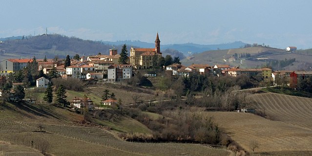
Кастель-Больоне (Castel Boglione, Castel Boglione)

- коммуна Италии
 Hiking in Кастель-Больоне
Castel Boglione is a charming village located in the Piedmont region of northern Italy. Surrounded by the scenic hills of the Langhe and Monferrato, it offers a variety of hiking opportunities that appeal to outdoor enthusiasts and nature lovers alike.
Hiking Trails
-
Local Trails: The region boasts a network of well-marked trails that wind through vineyards, rolling hills, and picturesque landscapes. Some paths may lead to panoramic viewpoints, historical sites, or serene nature spots.
-
Wine Trails: Since Castel Boglione is situated in a renowned wine-producing area, there are trails that offer both hiking and wine-tasting experiences. These often connect small wineries and allow hikers to stop and sample local wines.
-
Nature Reserves: Nearby natural reserves may provide organized hiking trails with varying levels of difficulty. These areas often feature local flora and fauna, making them ideal for nature observation.
Best Times to Hike
- Spring (April to June): The weather is mild, and the surrounding landscapes come to life with blooming flowers, making it an excellent time for hiking.
- Fall (September to October): This is grape harvest season, and the hills are particularly beautiful with fall colors, plus numerous local festivals celebrating the harvest.
Preparation Tips
- Gear Up: Wear comfortable hiking shoes and clothes suitable for the weather. A good backpack with water, snacks, and a first-aid kit is essential.
- Navigation: While many trails are well-marked, it's a good idea to carry a map or GPS device, especially if you plan on exploring less familiar paths.
- Respect the Environment: Follow Leave No Trace principles to keep the area pristine for future hikers.
Local Attractions
Besides hiking, Castel Boglione offers charming local architecture, including historic buildings and community events. After a day on the trails, you might enjoy visiting a local trattoria to sample Piedmontese cuisine.
Whether you're looking for an intense hike, leisurely strolls, or a blend of both with cultural experiences, Castel Boglione has something to offer every hiking enthusiast.
- Страна:

- Почтовый код: 14040
- Телефонный код: 0141
- Код автомобильного номера: AT
- Координаты: 44° 43' 22" N, 8° 22' 52" E


- GPS треки (wikiloc): [Ссылка]
- Высота над уровнем моря: 260 м m
- Площадь: 11.86 кв.км
- Население: 602
- Веб сайт: http://www.comune.castelboglione.at.it
- Википедия русская: wiki(ru)
- Википедия английская: wiki(en)
- Википедия национальная: wiki(it)
- Хранилище Wikidata: Wikidata: Q17775
- код Freebase: [/m/0gbg3y]
- код GeoNames: Альт: [6542384]
- код VIAF: Альт: [150435018]
- ID отношения в OpenStreetMap: [43517]
- UN/LOCODE: [ITCBO]
- код ISTAT: 005024
- кадастровый код Италии: C064
Граничит с регионами:


Каламандрана
- коммуна Италии
Hiking in Каламандрана
Calamandrana is a quaint town located in the Piedmont region of Italy, surrounded by picturesque landscapes that make it a great spot for hiking enthusiasts. The area is known for its stunning vineyards, rolling hills, and rich cultural heritage, which adds to the hiking experience....
- Страна:
- Почтовый код: 14042
- Телефонный код: 0141
- Код автомобильного номера: AT
- Координаты: 44° 44' 17" N, 8° 20' 23" E
- GPS треки (wikiloc): [Ссылка]
- Высота над уровнем моря: 151 м m
- Площадь: 12.79 кв.км
- Население: 1745
- Веб сайт: [Ссылка]

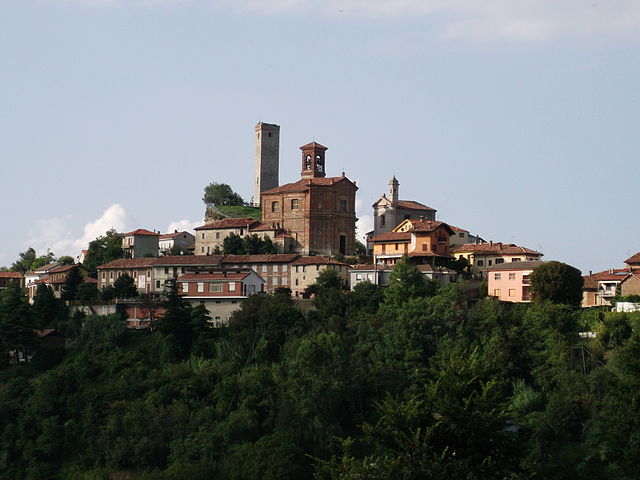
Кастель-Роккеро
- коммуна Италии
Hiking in Кастель-Роккеро
Castel Rocchero is a beautiful area located in the Piedmont region of Italy, known for its stunning landscapes, rolling hills, and vineyards. Hiking in Castel Rocchero is a fantastic way to explore the natural beauty of this region. Here are some key points to consider when planning your hike:...
- Страна:
- Почтовый код: 14040
- Телефонный код: 0141
- Код автомобильного номера: AT
- Координаты: 44° 43' 9" N, 8° 24' 59" E
- GPS треки (wikiloc): [Ссылка]
- Высота над уровнем моря: 414 м m
- Площадь: 5.63 кв.км
- Население: 396
- Веб сайт: [Ссылка]


Фонтаниле
- коммуна Италии
Hiking in Фонтаниле
Fontanile is a small area located in Italy, often characterized by its picturesque landscapes and natural beauty. While specific hiking trails may not be extensively documented, the surrounding regions, like the hills and countryside of Italy, offer fantastic opportunities for hikers....
- Страна:
- Почтовый код: 14044
- Телефонный код: 0141
- Код автомобильного номера: AT
- Координаты: 44° 45' 11" N, 8° 25' 17" E
- GPS треки (wikiloc): [Ссылка]
- Высота над уровнем моря: 276 м m
- Площадь: 8.13 кв.км
- Население: 560
- Веб сайт: [Ссылка]


Монтабоне
- коммуна Италии
Hiking in Монтабоне
Montabone is a picturesque area located in the Piedmont region of Italy, known for its beautiful landscapes, rolling hills, and vineyards. If you're considering hiking in Montabone, here are some key points to keep in mind:...
- Страна:
- Почтовый код: 14040
- Телефонный код: 0141
- Код автомобильного номера: AT
- Координаты: 44° 41' 59" N, 8° 23' 30" E
- GPS треки (wikiloc): [Ссылка]
- Высота над уровнем моря: 454 м m
- Площадь: 8.54 кв.км
- Население: 342
- Веб сайт: [Ссылка]


Ницца-Монферрато
- Коммуна в Италии, располагается в регионе Пьемонт, подчиняется административному центру Асти.
Hiking in Ницца-Монферрато
Nizza Monferrato, located in the Piedmont region of Italy, is known for its beautiful landscapes, rolling hills, vineyards, and rich cultural heritage. It's a fantastic area for hiking, offering a variety of trails suitable for different skill levels, with options for both leisurely walks and more challenging hikes....
- Страна:
- Почтовый код: 14049
- Телефонный код: 0141
- Код автомобильного номера: AT
- Координаты: 44° 46' 29" N, 8° 21' 18" E
- GPS треки (wikiloc): [Ссылка]
- Высота над уровнем моря: 137 м m
- Площадь: 30.36 кв.км
- Население: 10313
- Веб сайт: [Ссылка]

Роккетта-Палафеа
- коммуна Италии
Hiking in Роккетта-Палафеа
Rocchetta Palafea is a charming village located in the Piedmont region of Italy, surrounded by beautiful landscapes that make it an excellent destination for hiking enthusiasts. Here are some key points to consider if you're planning a hiking trip in and around Rocchetta Palafea:...
- Страна:
- Почтовый код: 14040
- Телефонный код: 0141
- Код автомобильного номера: AT
- Координаты: 44° 42' 30" N, 8° 20' 47" E
- GPS треки (wikiloc): [Ссылка]
- Высота над уровнем моря: 423 м m
- Площадь: 7.84 кв.км
- Население: 346
- Веб сайт: [Ссылка]