
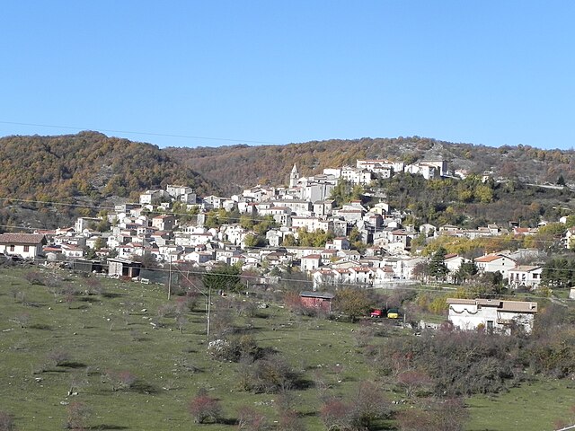
Кастель-ди-Сангро (Castel di Sangro, Castel di Sangro)

.svg)
- коммуна Италии
 Hiking in Кастель-ди-Сангро
Castel di Sangro is located in the Abruzzo region of Italy and is known for its stunning natural landscapes, rich history, and proximity to the Abruzzo, Lazio, and Molise National Park. Hiking in this area offers a variety of trails that cater to different skill levels, making it a great destination for both novice and experienced hikers.
Trails and Areas to Explore:
-
Parco Nazionale d’Abruzzo, Lazio e Molise:
- This national park is a treasure trove for hikers, with numerous trails ranging from easy walks to challenging treks. You can encounter diverse wildlife, including wolves, bears, and various bird species. Popular hikes in the park lead to scenic viewpoints, dense forests, and open meadows.
-
Piani di Vaccio:
- A beautiful plateau that provides some fantastic hiking routes. Trails here often lead to stunning panoramic views and may take you through picturesque valleys and alpine landscapes.
-
Camerelle Viewpoint:
- This is a rewarding hike that offers breathtaking views of the surrounding mountains and valleys. The trail is well-marked and suitable for most hikers.
-
Roccaraso and Rivisondoli:
- Nearby towns like Roccaraso and Rivisondoli also offer access to various hiking trails. These routes are set in beautiful landscapes and can lead you to scenic spots ideal for picnicking.
Tips for Hiking in Castel di Sangro:
- Preparation: Always check the weather forecast before you head out. The weather can change rapidly in the mountains.
- Gear: Wear appropriate footwear, and ensure you have sufficient water, snacks, a map or GPS, and a first aid kit.
- Respect Nature: Stay on marked trails, do not disturb wildlife, and follow the Leave No Trace principles to protect the environment.
- Local Guides: If you're unfamiliar with the area or want to enhance your hiking experience, consider hiring a local guide. They can provide insights into the region’s natural history and culture.
Local Culture:
Enjoying Castel di Sangro isn't just about the hikes; immerse yourself in the local culture by trying traditional cuisine and visiting historic sites in the town. The area is known for its hearty dishes, including those made with local game, cheeses, and homemade pasta.
Hiking in Castel di Sangro allows you to connect with nature while exploring one of Italy's lesser-known yet stunning regions. Whether you're on a short day hike or planning a more extended trekking adventure, you're sure to enjoy the spectacular scenery and fresh mountain air.
- Страна:

- Почтовый код: 67031
- Телефонный код: 0864
- Код автомобильного номера: AQ
- Координаты: 41° 47' 3" N, 14° 6' 31" E


- GPS треки (wikiloc): [Ссылка]
- Высота над уровнем моря: 805 м m
- Площадь: 84.44 кв.км
- Население: 6705
- Веб сайт: http://www.comune.casteldisangro.aq.it/
- Википедия русская: wiki(ru)
- Википедия английская: wiki(en)
- Википедия национальная: wiki(it)
- Хранилище Wikidata: Wikidata: Q50073
- Галерея изображений в википедии: [Ссылка]
- Катеория в википедии: [Ссылка]
- код Freebase: [/m/05ld7b]
- код GeoNames: Альт: [6540706]
- код VIAF: Альт: [296879872]
- ID отношения в OpenStreetMap: [41519]
- код GND: Альт: [4216284-1]
- идентификатор местоположения ArchINFORM: [14913]
- код LCNAF: Альт: [n87882007]
- WOEID: [713227]
- UN/LOCODE: [ITCS5]
- Google Maps Customer ID: [5558366881411460093]
- код ISTAT: 066028
- кадастровый код Италии: C096
Граничит с регионами:


Черро-аль-Вольтурно
- коммуна Италии
Hiking in Черро-аль-Вольтурно
Cerro al Volturno is a picturesque area located in the province of Isernia, in the Molise region of Italy. This destination is particularly popular among hikers and nature enthusiasts due to its stunning landscapes, rich biodiversity, and cultural heritage. Here’s what you can expect when hiking in and around Cerro al Volturno:...
- Страна:
- Почтовый код: 86072
- Телефонный код: 0865
- Код автомобильного номера: IS
- Координаты: 41° 39' 0" N, 14° 8' 0" E
- GPS треки (wikiloc): [Ссылка]
- Высота над уровнем моря: 572 м m
- Площадь: 23.79 кв.км
- Население: 1250
- Веб сайт: [Ссылка]

Монтенеро-Валь-Коккьяра
- коммуна Италии
Hiking in Монтенеро-Валь-Коккьяра
Montenero Val Cocchiara is a beautiful, lesser-known destination in the Italian region of Molise. Nestled in the Apennine Mountains, it offers a range of hiking opportunities surrounded by stunning natural scenery, quaint villages, and rich history. Here’s what you can expect when hiking in this area:...
- Страна:
- Почтовый код: 86080
- Телефонный код: 0865
- Код автомобильного номера: IS
- Координаты: 41° 43' 0" N, 14° 4' 0" E
- GPS треки (wikiloc): [Ссылка]
- Высота над уровнем моря: 893 м m
- Площадь: 22.02 кв.км
- Население: 514
- Веб сайт: [Ссылка]
Рьонеро-Саннитико
- коммуна Италии
Hiking in Рьонеро-Саннитико
Rionero Sannitico is a picturesque village located in the Molise region of Italy, surrounded by the stunning landscapes of the Apennine Mountains. Hiking in and around Rionero Sannitico offers a unique opportunity to explore both the natural beauty and the cultural heritage of this lesser-known area....
- Страна:
- Почтовый код: 86087
- Телефонный код: 0865
- Код автомобильного номера: IS
- Координаты: 41° 43' 0" N, 14° 8' 0" E
- GPS треки (wikiloc): [Ссылка]
- Высота над уровнем моря: 1051 м m
- Площадь: 29.22 кв.км
- Население: 1130
- Веб сайт: [Ссылка]


Сан-Пьетро-Авеллана
- коммуна Италии
Hiking in Сан-Пьетро-Авеллана
San Pietro Avellana is a charming village located in the Molise region of Italy, surrounded by the scenic landscapes of the Apennines. The area offers numerous opportunities for hiking enthusiasts to explore its natural beauty, rich flora and fauna, and stunning views....
- Страна:
- Почтовый код: 86088
- Телефонный код: 0865
- Код автомобильного номера: IS
- Координаты: 41° 47' 31" N, 14° 10' 53" E
- GPS треки (wikiloc): [Ссылка]
- Высота над уровнем моря: 960 м m
- Площадь: 44.95 кв.км
- Население: 515
- Веб сайт: [Ссылка]


Вастоджирарди
- коммуна Италии
Hiking in Вастоджирарди
Vastogirardi is a delightful hidden gem located in the Molise region of Italy, known for its stunning landscapes, rich history, and outdoor recreational opportunities. Here are some highlights of hiking in Vastogirardi:...
- Страна:
- Почтовый код: 86089
- Телефонный код: 0865
- Код автомобильного номера: IS
- Координаты: 41° 46' 0" N, 14° 16' 0" E
- GPS треки (wikiloc): [Ссылка]
- Высота над уровнем моря: 1200 м m
- Площадь: 60.71 кв.км
- Население: 684
- Веб сайт: [Ссылка]

Ривизондоли
- коммуна Италии
Hiking in Ривизондоли
Rivisondoli is a picturesque village located in the Abruzzo region of Italy, nestled in the stunning Apennine mountains. It's known for its natural beauty, making it an excellent destination for hiking enthusiasts. Here’s what you need to know about hiking in Rivisondoli:...
- Страна:
- Почтовый код: 67036
- Телефонный код: 0864
- Код автомобильного номера: AQ
- Координаты: 41° 52' 16" N, 14° 4' 3" E
- GPS треки (wikiloc): [Ссылка]
- Высота над уровнем моря: 1320 м m
- Площадь: 32 кв.км
- Население: 688
- Веб сайт: [Ссылка]


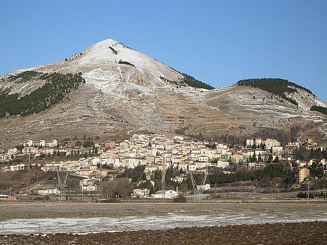
Роккаразо
- коммуна Италии
Hiking in Роккаразо
Roccaraso is a charming destination in the Apennine Mountains, located in the Abruzzo region of central Italy. Famous for its ski resorts in winter, it's also a fantastic location for hiking during the warmer months. Here are some key points to consider if you’re planning a hiking adventure in Roccaraso:...
- Страна:
- Почтовый код: 67037
- Телефонный код: 0864
- Код автомобильного номера: AQ
- Координаты: 41° 50' 48" N, 14° 4' 43" E
- GPS треки (wikiloc): [Ссылка]
- Высота над уровнем моря: 1236 м m
- Площадь: 49.91 кв.км
- Население: 1702
- Веб сайт: [Ссылка]
Сконтроне
- коммуна Италии
Hiking in Сконтроне
Scontrone is a charming town located in the Abruzzo region of Italy, surrounded by stunning natural landscapes, making it an excellent destination for hiking enthusiasts. The area offers a variety of trails that cater to different skill levels, from beginners to experienced hikers....
- Страна:
- Почтовый код: 67030
- Телефонный код: 0864
- Код автомобильного номера: AQ
- Координаты: 41° 44' 54" N, 14° 2' 25" E
- GPS треки (wikiloc): [Ссылка]
- Высота над уровнем моря: 1038 м m
- Площадь: 21.36 кв.км
- Население: 582
- Веб сайт: [Ссылка]