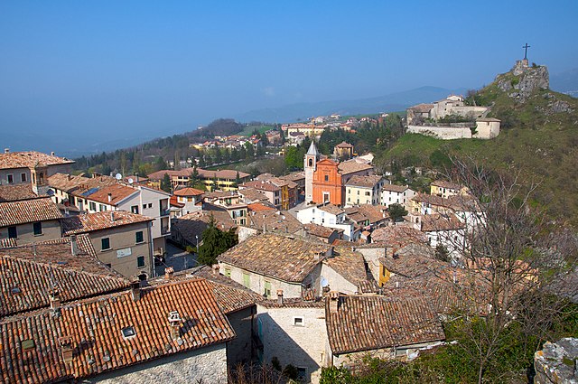
Кастельдельчи (Casteldelci, Casteldelci)
.svg)
- коммуна Италии
 Hiking in Кастельдельчи
Casteldelci is a charming village located in the Emilia-Romagna region of Italy, nestled in the beautiful hills of the Appennine Mountains. Known for its stunning landscapes and rich natural diversity, the area offers a variety of hiking opportunities for all levels of experience. Here are some key aspects to consider when hiking in Casteldelci:
Trails and Routes
-
Scenic Views: Many hiking trails around Casteldelci provide breathtaking views of the surrounding mountains, valleys, and forests. You can expect to encounter beautiful landscapes, including lush greenery and rocky terrain.
-
Difficulty Levels: The hikes in the area range from easy walks suitable for families to challenging routes for experienced hikers. Make sure to choose a trail that suits your fitness level and experience.
-
Parks and Reserves: The nearby Sasso Simone and Simoncello Regional Park features several marked trails. This park is known for its rich biodiversity, including flora and fauna unique to the region.
Hiking Experience
-
Cultural Aspects: Hiking in Casteldelci allows you to immerse yourself in local culture. You'll encounter traditional stone villages, ancient churches, and culinary delights at local eateries.
-
Wildlife Spotting: The area is a habitat for various wildlife species. Hikers may spot deer, wild boar, and numerous bird species along the trails.
-
Seasonal Changes: Each season offers a different experience. Spring brings blooming flowers, summer has vibrant green landscapes, autumn showcases beautiful foliage, and winter can offer a different adventure if there's snow.
Preparation and Safety
-
Gear: Depending on the season, proper hiking gear is essential. Sturdy hiking boots, weather-appropriate clothing, and plenty of water are recommended.
-
Maps and Guides: While many trails are well-marked, carrying a map or a guidebook can help navigate more challenging areas.
-
Local Guidance: Consider joining a local hiking group or hiring a guide, especially if you’re unfamiliar with the area or looking for specific trails.
Accessibility
-
Transportation: Ensure you have transportation to the trailheads, as public transport options may be limited in rural areas.
-
Accommodations: Casteldelci has various lodging options, from rustic agriturismi to more modern accommodations, making it convenient for hikers wanting to explore the region over several days.
Conclusion
Hiking in Casteldelci is an enriching experience, merging adventure with the beauty of nature and the charm of Italian culture. Whether you’re an experienced hiker or just starting, the trails here offer something for everyone. Always remember to leave no trace and respect the natural environment while enjoying your hike!
- Страна:

- Почтовый код: 47861
- Телефонный код: 0541
- Код автомобильного номера: RN
- Координаты: 43° 47' 29" N, 12° 9' 19" E


- GPS треки (wikiloc): [Ссылка]
- Высота над уровнем моря: 632 м m
- Площадь: 49.68 кв.км
- Население: 389
- Веб сайт: http://www.comune.casteldelci.pu.it/
- Википедия русская: wiki(ru)
- Википедия английская: wiki(en)
- Википедия национальная: wiki(it)
- Хранилище Wikidata: Wikidata: Q111796
- Катеория в википедии: [Ссылка]
- код Freebase: [/m/0gl42h]
- код GeoNames: Альт: [6543019]
- код VIAF: Альт: [137554477]
- ID отношения в OpenStreetMap: [42606]
- код ISTAT: 099021
- кадастровый код Италии: C080
Граничит с регионами:

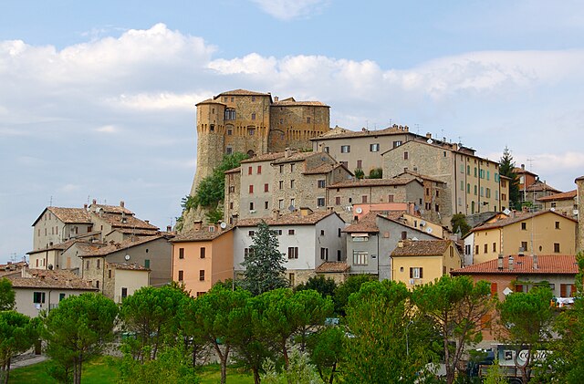
Пеннабилли
- коммуна Италии
Hiking in Пеннабилли
Pennabilli is a picturesque town located in the Emilia-Romagna region of Italy, known for its stunning landscapes, historical significance, and rich natural beauty. It’s an excellent destination for hiking enthusiasts who seek to explore the outdoors while enjoying cultural heritage....
- Страна:
- Почтовый код: 47864
- Телефонный код: 0541
- Код автомобильного номера: RN
- Координаты: 43° 49' 8" N, 12° 16' 0" E
- GPS треки (wikiloc): [Ссылка]
- Высота над уровнем моря: 629 м m
- Площадь: 69.66 кв.км
- Население: 2772
- Веб сайт: [Ссылка]

Сант'Агата-Фельтрия
- коммуна Италии
Hiking in Сант'Агата-Фельтрия
Sant'Agata Feltria is a charming town located in the Emilia-Romagna region of Italy, surrounded by beautiful natural landscapes, making it an excellent destination for hiking enthusiasts. Here’s what you should know about hiking in this area:...
- Страна:
- Почтовый код: 47866
- Телефонный код: 0547
- Код автомобильного номера: RN
- Координаты: 43° 51' 50" N, 12° 12' 31" E
- GPS треки (wikiloc): [Ссылка]
- Высота над уровнем моря: 606 м m
- Площадь: 79.74 кв.км
- Население: 2121
- Веб сайт: [Ссылка]


Бадия-Тедальда
- коммуна Италии
Hiking in Бадия-Тедальда
Badia Tedalda is a beautiful destination located in the province of Arezzo in Tuscany, Italy. Nestled in the Valtiberina valley, this area is known for its stunning landscapes, rich history, and natural beauty, making it an excellent spot for hiking enthusiasts....
- Страна:
- Почтовый код: 53032
- Телефонный код: 0575
- Код автомобильного номера: AR
- Координаты: 43° 42' 29" N, 12° 11' 14" E
- GPS треки (wikiloc): [Ссылка]
- Высота над уровнем моря: 700 м m
- Площадь: 119.03 кв.км
- Население: 1075
- Веб сайт: [Ссылка]


Сестино
- коммуна Италии
Hiking in Сестино
Sestino, a charming town located in the Emilia-Romagna region of Italy, offers a wonderful backdrop for hiking enthusiasts. Nestled in the picturesque hills of the Apennines, it boasts scenic landscapes, historical sites, and a variety of trails that cater to hikers of all skill levels....
- Страна:
- Почтовый код: 52038
- Телефонный код: 0575
- Код автомобильного номера: AR
- Координаты: 43° 42' 38" N, 12° 17' 56" E
- GPS треки (wikiloc): [Ссылка]
- Высота над уровнем моря: 456 м m
- Площадь: 80.22 кв.км
- Население: 1309
- Веб сайт: [Ссылка]
Вергерето
- коммуна регионе Эмилия-Романья, Италия
Hiking in Вергерето
Verghereto, located in the province of Forlì-Cesena in Emilia-Romagna, Italy, is an excellent destination for hiking enthusiasts. Nestled in the Apennine Mountains, the region is characterized by its stunning landscapes, lush forests, and a variety of trails suitable for different skill levels....
- Страна:
- Почтовый код: 47028
- Телефонный код: 0543
- Код автомобильного номера: FC
- Координаты: 43° 48' 0" N, 11° 58' 0" E
- GPS треки (wikiloc): [Ссылка]
- Высота над уровнем моря: 812 м m
- Площадь: 117.9 кв.км
- Население: 1860
- Веб сайт: [Ссылка]