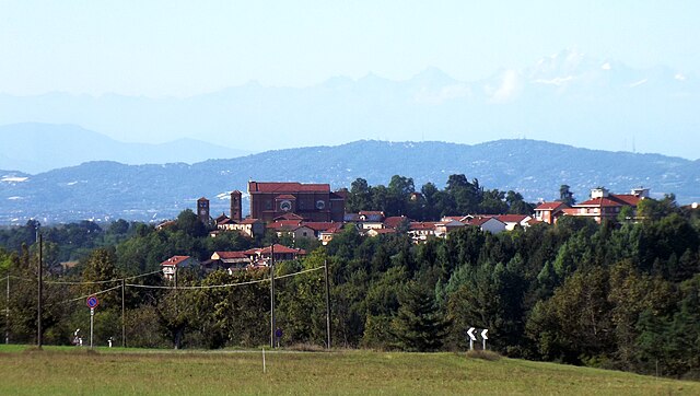
Челларенго (Cellarengo, Cellarengo)

- коммуна Италии
 Hiking in Челларенго
Cellarengo is a small town located in the Piedmont region of Italy, and while it might not be widely known for hiking specifically, there are opportunities to explore the natural beauty of the surrounding area. The region is characterized by rolling hills, vineyards, and picturesque landscapes typical of Piedmont.
Here are some points to consider if you are planning to hike in or near Cellarengo:
-
Local Trails: While the town itself may not have dedicated hiking trails, you’re likely to find “sentieri” (paths) that wind through the countryside, connecting Cellarengo to neighboring towns and scenic vistas. Exploring these may require some research or local guidance.
-
Nearby Parks: You could venture to nearby natural parks and reserves such as the Riserva Naturale Speciale delle Baragge or the Parco Naturale dei Gessi Bolognesi to find more structured hiking opportunities. These parks offer a variety of trails suitable for different skill levels.
-
Wine and Food: The Piedmont region is famous for its wine and cuisine, so consider merging your hiking experience with visits to local vineyards or agriturismi (farm stays), where you can also enjoy local delicacies after your hike.
-
Preparation: Since Cellarengo is not a major tourist destination, ensure you bring along a detailed map or GPS device and check local guidelines and trail conditions before you head out.
-
Weather Considerations: The best time to hike in this region is during the spring and fall, when temperatures are typically mild. Summer can be quite hot, while winter may bring snow in higher altitudes.
-
Cultural Sites: Combine your hiking with visits to local landmarks such as churches and historical buildings, enriching your hike with cultural insights.
For a fulfilling hiking experience in Cellarengo, be sure to plan ahead, consider the local terrain, and enjoy the beautiful backdrops that this charming region offers!
- Страна:

- Почтовый код: 14010
- Телефонный код: 0141
- Код автомобильного номера: AT
- Координаты: 44° 51' 55" N, 7° 56' 47" E


- GPS треки (wikiloc): [Ссылка]
- Высота над уровнем моря: 321 м m
- Площадь: 10.85 кв.км
- Население: 700
- Веб сайт: http://www.comune.cellarengo.at.it
- Википедия русская: wiki(ru)
- Википедия английская: wiki(en)
- Википедия национальная: wiki(it)
- Хранилище Wikidata: Wikidata: Q17786
- код Freebase: [/m/0gbgdm]
- код GeoNames: Альт: [6542387]
- ID отношения в OpenStreetMap: [43725]
- код ISTAT: 005033
- кадастровый код Италии: C438
Граничит с регионами:

Пойрино
- коммуна Италии
Hiking in Пойрино
Poirino, located in the Piedmont region of Italy, is surrounded by rolling hills, vineyards, and beautiful landscapes that make it a great destination for hiking. While Poirino itself may not have an extensive network of hiking trails, its proximity to the surrounding areas offers plenty of options for outdoor enthusiasts....
- Страна:
- Почтовый код: 10046
- Телефонный код: 011
- Код автомобильного номера: TO
- Координаты: 44° 55' 0" N, 7° 51' 0" E
- GPS треки (wikiloc): [Ссылка]
- Высота над уровнем моря: 249 м m
- Площадь: 75.62 кв.км
- Население: 10576
- Веб сайт: [Ссылка]

Пралормо
- коммуна Италии
Hiking in Пралормо
Pralormo is a charming village located in the Piedmont region of Italy, known for its beautiful landscapes and rich cultural heritage. While it may not be as widely recognized as other hiking destinations in Italy, it offers some lovely opportunities for outdoor enthusiasts....
- Страна:
- Почтовый код: 10040
- Телефонный код: 011
- Код автомобильного номера: TO
- Координаты: 44° 52' 0" N, 7° 54' 0" E
- GPS треки (wikiloc): [Ссылка]
- Высота над уровнем моря: 303 м m
- Площадь: 29.85 кв.км
- Население: 1948
- Веб сайт: [Ссылка]
Вальфенера
- коммуна Италии
Hiking in Вальфенера
Valfenera, located in the Piedmont region of Italy, offers scenic landscapes and a variety of outdoor activities, including hiking. Although it may not be as widely known as some other hiking hotspots, it has its own charm with rolling hills, vineyards, and picturesque rural settings....
- Страна:
- Почтовый код: 14017
- Телефонный код: 0141
- Код автомобильного номера: AT
- Координаты: 44° 54' 10" N, 7° 57' 55" E
- GPS треки (wikiloc): [Ссылка]
- Высота над уровнем моря: 282 м m
- Площадь: 22.04 кв.км
- Население: 2464
- Веб сайт: [Ссылка]

Монта
- коммуна Италии
Hiking in Монта
Montà, located in the Piedmont region of Italy, is known for its picturesque landscapes, rolling hills, and vineyards, making it a charming destination for hiking enthusiasts. Here are some highlights and tips for hiking in Montà:...
- Страна:
- Почтовый код: 12046
- Телефонный код: 0173
- Код автомобильного номера: CN
- Координаты: 44° 48' 53" N, 7° 57' 17" E
- GPS треки (wikiloc): [Ссылка]
- Высота над уровнем моря: 316 м m
- Площадь: 26.82 кв.км
- Население: 4712
- Веб сайт: [Ссылка]
Изолабелла
- коммуна Италии
Hiking in Изолабелла
Isolabella, located in the province of Turin, offers a picturesque backdrop for hiking enthusiasts. While Isolabella itself is a small municipality, it's within proximity to various trails and natural areas in the surrounding region, particularly in the Susa Valley and the nearby Olympic Mountains....
- Страна:
- Почтовый код: 10046
- Телефонный код: 011
- Код автомобильного номера: TO
- Координаты: 44° 54' 0" N, 7° 55' 0" E
- GPS треки (wikiloc): [Ссылка]
- Высота над уровнем моря: 256 м m
- Площадь: 4.77 кв.км
- Население: 380
- Веб сайт: [Ссылка]