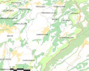
Cernay-l'Église (Cernay-l'Église)

- коммуна во Франции
 Hiking in Cernay-l'Église
Cernay-l'Église, located in the northeastern part of France, is surrounded by beautiful natural landscapes that offer various hiking opportunities for enthusiasts. While it may not be as well-known as some other hiking destinations in the country, its rural charm and proximity to nature make it a lovely spot for outdoor activities.
Hiking Trails
-
Local Paths: There are several local trails that wind through the countryside, featuring serene views of fields, forests, and small streams. These paths are often suitable for all skill levels and can be explored on foot or by bike.
-
Nearby Nature Reserves: The area around Cernay-l'Église may offer access to local nature reserves or forests. These areas typically have marked trails with varying levels of difficulty.
-
Regional Hiking Routes: Cernay-l'Église is not far from larger natural parks, such as the Parc Naturel Régional de la Haute Vallée de Chevreuse. Here, you can find a network of well-maintained hiking trails that offer stunning views, picnic spots, and the chance to see local wildlife.
Best Practices
- Preparation: Always check the weather forecast before heading out and dress in layers. Good hiking shoes are essential due to varied terrain.
- Maps and GPS: It's a good idea to carry a map or download reliable hiking apps to navigate the trails, especially in less populated areas.
- Leave No Trace: Follow the principles of Leave No Trace to preserve the beauty of nature for future hikers.
Accessibility
Cernay-l'Église is generally accessible by road, and you may need to drive to reach specific trails or nature reserves. Public transport options may be limited in rural areas, so planning ahead is crucial.
Local Tips
- Explore Local Flora and Fauna: Take some time to learn about the local wildlife and plants, which can enhance your hiking experience.
- Cultural Sites: Consider combining your hike with visits to local cultural or historical sites in and around the village for a more enriching experience.
Overall, hiking in and around Cernay-l'Église offers a peaceful retreat into nature, perfect for appreciating the tranquility of the French countryside.
- Страна:

- Почтовый код: 25120
- Координаты: 47° 15' 26" N, 6° 49' 51" E


- GPS треки (wikiloc): [Ссылка]
- Площадь: 5.95 кв.км
- Население: 304
- Википедия английская: wiki(en)
- Википедия национальная: wiki(fr)
- Хранилище Wikidata: Wikidata: Q574730
- Катеория в википедии: [Ссылка]
- код Freebase: [/m/03mgrr6]
- код Freebase: [/m/03mgrr6]
- код GeoNames: Альт: [6429696]
- код GeoNames: Альт: [6429696]
- номер SIREN: [212501084]
- номер SIREN: [212501084]
- код BNF: [15252334v]
- код BNF: [15252334v]
- код муниципалитета INSEE: 25108
- код муниципалитета INSEE: 25108
Граничит с регионами:


Charquemont
- коммуна во Франции
Hiking in Charquemont
Charquemont is a picturesque village located in the Franche-Comté region of eastern France, known for its beautiful landscapes and outdoor opportunities, making it an excellent destination for hiking enthusiasts. Here are some highlights about hiking in and around Charquemont:...
- Страна:
- Почтовый код: 25140
- Координаты: 47° 12' 51" N, 6° 49' 18" E
- GPS треки (wikiloc): [Ссылка]
- Площадь: 21.44 кв.км
- Население: 2644
- Веб сайт: [Ссылка]


Maîche
- коммуна во Франции
Hiking in Maîche
Maîche is a charming town located in the Doubs department of France, nestled in the Jura Mountains. This region is known for its stunning landscapes, rich biodiversity, and various outdoor activities, including hiking. Here are some highlights about hiking in and around Maîche:...
- Страна:
- Почтовый код: 25120
- Координаты: 47° 15' 4" N, 6° 48' 13" E
- GPS треки (wikiloc): [Ссылка]
- Площадь: 17.42 кв.км
- Население: 4273
- Веб сайт: [Ссылка]

Damprichard
- коммуна во Франции
Hiking in Damprichard
Damprichard is a charming commune located in the Doubs department of the Bourgogne-Franche-Comté region in eastern France. It offers a picturesque setting for outdoor enthusiasts, especially hikers. Here are some highlights about hiking in and around Damprichard:...
- Страна:
- Почтовый код: 25450
- Координаты: 47° 14' 40" N, 6° 52' 53" E
- GPS треки (wikiloc): [Ссылка]
- Площадь: 21.9 кв.км
- Население: 1872
- Веб сайт: [Ссылка]


Thiébouhans
- коммуна во Франции
Hiking in Thiébouhans
Thiébouhans is a charming village located in the Doubs department of the Bourgogne-Franche-Comté region in eastern France. While it may not be as widely known as some other hiking destinations, it offers picturesque landscapes and opportunities for outdoor activities....
- Страна:
- Почтовый код: 25470
- Координаты: 47° 16' 51" N, 6° 50' 47" E
- GPS треки (wikiloc): [Ссылка]
- Площадь: 5.81 кв.км
- Население: 253