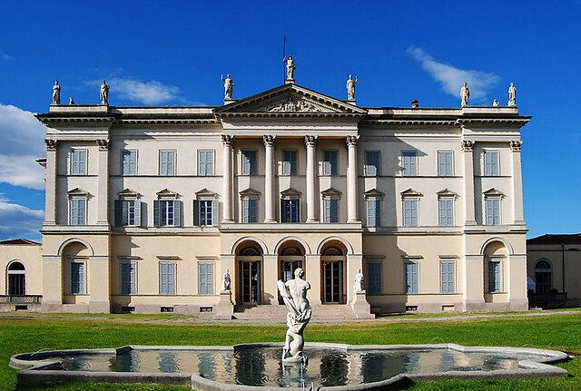
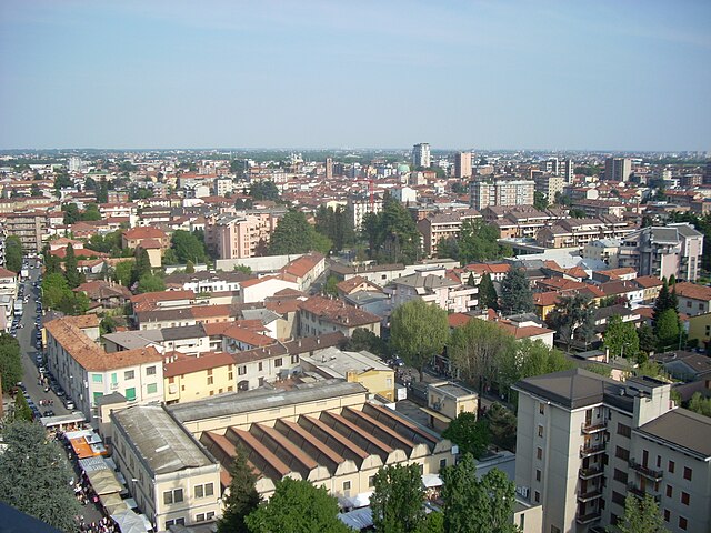
Чезано-Мадерно (Cesano Maderno, Cesano Maderno)
.svg)
- коммуна Италии
 Hiking in Чезано-Мадерно
Cesano Maderno, located in the Lombardy region of Italy, offers a range of hiking opportunities that showcase both its natural beauty and cultural heritage. The area is characterized by rolling hills, lush forests, and scenic views, making it an attractive destination for outdoor enthusiasts.
Hiking Trails:
-
Parco della Brughiera Briantea: This nearby natural park features various trails suitable for all skill levels. Hikers can enjoy meandering paths through woodlands, and fields, and by small streams. Look for the diverse flora and fauna native to this area.
-
Sentiero dei Cacciatori: This trail offers a more rugged experience through the hills surrounding Cesano Maderno. It's a lovely way to explore the local landscape, with opportunities for spotting wildlife and enjoying panoramic views.
-
Trail to the Monastery of San Francesco: A cultural hike that leads to this historic site. The route is relatively easy and provides the chance to learn more about the region's history while enjoying the natural surroundings.
Tips for Hiking in Cesano Maderno:
- Best Time to Hike: The ideal months for hiking are in the spring (April to June) and autumn (September to October) when the weather is pleasant, and the scenery is vibrant.
- Equipment: Make sure to wear sturdy hiking boots and bring sufficient water, snacks, and a map or GPS device.
- Local Guides: Consider hiring a local guide if you want to learn more about the area’s ecology and history.
- Wildlife Respect: Be mindful of local wildlife; keep a safe distance and do not feed animals.
Additional Activities:
- After a hike, you might enjoy visiting local restaurants to sample traditional Lombard cuisine.
- Explore historical landmarks within Cesano Maderno, including old churches and palazzos.
Whether you're looking for a tranquil walk in nature or a more strenuous hike, Cesano Maderno has something to offer for every hiker.
- Страна:

- Почтовый код: 20811
- Телефонный код: 0362
- Код автомобильного номера: MB
- Координаты: 45° 37' 38" N, 9° 8' 50" E


- GPS треки (wikiloc): [Ссылка]
- Высота над уровнем моря: 198 м m
- Площадь: 11.51 кв.км
- Население: 38614
- Веб сайт: http://www.comune.cesano-maderno.mb.it
- Википедия русская: wiki(ru)
- Википедия английская: wiki(en)
- Википедия национальная: wiki(it)
- Хранилище Wikidata: Wikidata: Q39973
- Катеория в википедии: [Ссылка]
- код Freebase: [/m/0dzx10]
- код GeoNames: Альт: [6541989]
- код VIAF: Альт: [157071046]
- ID отношения в OpenStreetMap: [45557]
- идентификатор местоположения ArchINFORM: [16449]
- место в MusicBrainz: [6c095e58-1c6b-4fbe-a6e4-0131b1718258]
- WOEID: [12678558]
- код темы Quora: [Cesano-Maderno]
- UN/LOCODE: [ITCEM]
- код в Большой каталанской энциклопедии: [0017206]
- код ISTAT: 108019
- кадастровый код Италии: C566
Граничит с регионами:
Кольяте
- коммуна Италии
Hiking in Кольяте
Cogliate is a charming area located in the Lombardy region of Italy, not far from the beautiful town of Monza and the vibrant city of Milan. While it may not be as famous as some other hiking destinations in Italy, it offers a variety of outdoor activities and natural beauty....
- Страна:
- Почтовый код: 20815
- Телефонный код: 02
- Код автомобильного номера: MB
- Координаты: 45° 38' 0" N, 9° 5' 0" E
- GPS треки (wikiloc): [Ссылка]
- Высота над уровнем моря: 236 м m
- Площадь: 6.96 кв.км
- Население: 8558
- Веб сайт: [Ссылка]

Дезио
- коммуна Италии
Hiking in Дезио
Desio is a town located in the Lombardy region of Italy, in the province of Monza and Brianza, not far from Milan. While Desio itself is mainly an urban area, it serves as a good starting point for exploring nearby natural attractions and hiking trails in the surrounding areas....
- Страна:
- Почтовый код: 20832
- Телефонный код: 0362
- Код автомобильного номера: MB
- Координаты: 45° 37' 0" N, 9° 13' 0" E
- GPS треки (wikiloc): [Ссылка]
- Высота над уровнем моря: 196 м m
- Площадь: 14.76 кв.км
- Население: 42031
- Веб сайт: [Ссылка]


Бовизио-Машиаго
- коммуна Италии
Hiking in Бовизио-Машиаго
Bovisio-Masciago is a charming town located in the Lombardy region of Italy, not far from Milan. While it's not primarily known for traditional hiking trails, it is situated near several natural areas and parks that offer great opportunities for outdoor activities, including walking and hiking....
- Страна:
- Почтовый код: 20813
- Телефонный код: 0362
- Код автомобильного номера: MB
- Координаты: 45° 37' 0" N, 9° 9' 0" E
- GPS треки (wikiloc): [Ссылка]
- Высота над уровнем моря: 188 м m
- Площадь: 4 кв.км
- Население: 17047
- Веб сайт: [Ссылка]

Сереньо
- коммуна Италии
Hiking in Сереньо
Seregno, located in the Lombardy region of Italy, offers beautiful landscapes and opportunities for hiking, especially in the surrounding areas. While Seregno itself is more urban, the nearby Brianza region is known for its scenic hills, forests, and walking trails. Here are some highlights for hiking in and around Seregno:...
- Страна:
- Почтовый код: 20831
- Телефонный код: 0362
- Код автомобильного номера: MB
- Координаты: 45° 39' 0" N, 9° 12' 0" E
- GPS треки (wikiloc): [Ссылка]
- Высота над уровнем моря: 222 м m
- Площадь: 13.05 кв.км
- Население: 44962
- Веб сайт: [Ссылка]


Севезо
- коммуна Италии
Hiking in Севезо
Seveso is a small town located in the Lombardy region of Italy, near Milan. While it's not particularly known as a hiking destination, there are some areas nearby where you can enjoy outdoor activities, including hiking....
- Страна:
- Почтовый код: 20822
- Телефонный код: 0362
- Код автомобильного номера: MB
- Координаты: 45° 38' 51" N, 9° 8' 19" E
- GPS треки (wikiloc): [Ссылка]
- Высота над уровнем моря: 211 м m
- Площадь: 7.4 кв.км
- Население: 23474
- Веб сайт: [Ссылка]


Чериано-Лагетто
- коммуна Италии
Hiking in Чериано-Лагетто
Ceriano Laghetto is a small town in the Lombardy region of Italy, not widely known for extensive hiking trails compared to more mountainous areas. However, it does offer some opportunities for outdoor activities, including hiking, particularly in the surrounding areas....
- Страна:
- Почтовый код: 20816
- Телефонный код: 02
- Код автомобильного номера: MB
- Координаты: 45° 38' 0" N, 9° 5' 0" E
- GPS треки (wikiloc): [Ссылка]
- Высота над уровнем моря: 216 м m
- Площадь: 7.08 кв.км
- Население: 6519
- Веб сайт: [Ссылка]