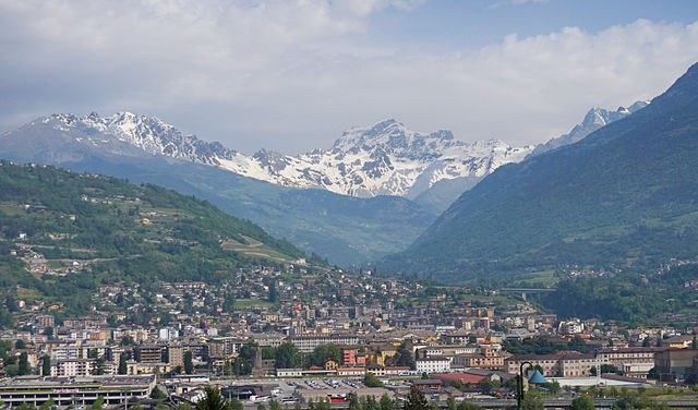
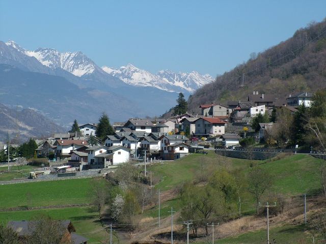
Шарвансо (Charvensod, Charvensod)
.svg)
- коммуна Италии
 Hiking in Шарвансо
Charvensod, a charming commune located in the Aosta Valley region of Italy, offers a variety of hiking opportunities that cater to all levels of hikers. Nestled at the foot of the impressive Mont Emilius, Charvensod is surrounded by stunning alpine scenery, making it an ideal base for outdoor activities.
Trails and Routes
-
Mont Emilius Trail: One of the more popular hikes starts from Charvensod and ascends towards Mont Emilius. It offers breathtaking views of Aosta and the surrounding valleys. The trail is moderately challenging but rewards hikers with panoramic vistas.
-
Valle del Rutor: This pathway takes you deeper into the untouched beauty of the Aosta Valley, showcasing lush forests and mountainous landscapes. It is suitable for various skill levels, so you can enjoy a leisurely hike or push for a more strenuous adventure.
-
Sentiero del Rame: The Copper Trail is a scenic route that highlights the local history and culture of the area, leading you through charming villages and past historical sites.
-
Charvensod Circuit: A loop trail around Charvensod that provides a gentle trek while enjoying the local flora and fauna. Perfect for families and casual walkers.
Best Time to Visit
While hiking can be enjoyed from late spring to early fall, summer (June to September) is the best time for hiking in Charvensod. During this season, the weather is warmer, the trails are clear of snow, and the mountain flowers are in bloom.
Preparation Tips
- Footwear: Sturdy hiking boots are recommended for the rocky trails.
- Weather: Always check the weather forecast before heading out, as conditions can change rapidly in the mountains.
- Hydration: Carry enough water, especially on longer hikes, as some trails may not have nearby water sources.
- Maps and Navigation: While trails are often well-marked, carrying a map or using a GPS device is wise, especially for more remote trails.
Local Amenities
Charvensod offers various accommodations, ranging from hotels to guesthouses. Local restaurants serve delicious regional cuisine, making it a great place to relax after a day of hiking.
Conclusion
Hiking in Charvensod provides an excellent opportunity to explore the natural beauty of the Aosta Valley. Whether you're an experienced hiker or just starting, the area offers something for everyone. Enjoy your adventure!
- Страна:

- Почтовый код: 11020
- Телефонный код: 0165
- Код автомобильного номера: AO
- Координаты: 45° 43' 0" N, 7° 19' 0" E


- GPS треки (wikiloc): [Ссылка]
- Высота над уровнем моря: 749 м m
- Площадь: 25.86 кв.км
- Население: 2428
- Веб сайт: http://comune.charvensod.ao.it
- Википедия русская: wiki(ru)
- Википедия английская: wiki(en)
- Википедия национальная: wiki(it)
- Хранилище Wikidata: Wikidata: Q34962
- Катеория в википедии: [Ссылка]
- Карты в википедии: [Ссылка]
- код Freebase: [/m/0fs_xc]
- код GeoNames: Альт: [6536458]
- ID отношения в OpenStreetMap: [45688]
- код ISTAT: 007019
- кадастровый код Италии: C598
Граничит с регионами:

Аоста
- коммуна Италии
Hiking in Аоста
Aosta, the capital of the Aosta Valley in Italy, is a fantastic destination for hiking enthusiasts. Nestled in the Italian Alps, the region offers stunning landscapes, charming villages, and a mix of both easy and challenging hiking trails. Here are some key points to consider for hiking in Aosta:...
- Страна:
- Почтовый код: 11100
- Телефонный код: 0165
- Код автомобильного номера: AO
- Координаты: 45° 44' 14" N, 7° 19' 14" E
- GPS треки (wikiloc): [Ссылка]
- Высота над уровнем моря: 583 м m
- Площадь: 21 кв.км
- Население: 34324
- Веб сайт: [Ссылка]


Бриссонь
- коммуна Италии
Hiking in Бриссонь
Brissogne is a charming small village located in the Aosta Valley region of Italy. It's known for its stunning natural scenery, including the surrounding mountains and lush landscapes, making it an excellent destination for hiking enthusiasts of all levels....
- Страна:
- Почтовый код: 11020
- Телефонный код: 0165
- Код автомобильного номера: AO
- Координаты: 45° 44' 0" N, 7° 24' 0" E
- GPS треки (wikiloc): [Ссылка]
- Высота над уровнем моря: 839 м m
- Площадь: 25.51 кв.км
- Население: 969
- Веб сайт: [Ссылка]


Конь
- коммуна Италии
Hiking in Конь
Cogne is a stunning valley located in the Aosta region of northern Italy, surrounded by the majestic Grand Paradiso National Park. It offers a variety of hiking opportunities that cater to different skill levels and preferences, from leisurely walks to challenging treks....
- Страна:
- Почтовый код: 11012
- Телефонный код: 0165
- Код автомобильного номера: AO
- Координаты: 45° 36' 27" N, 7° 21' 29" E
- GPS треки (wikiloc): [Ссылка]
- Высота над уровнем моря: 1534 м m
- Площадь: 213.04 кв.км
- Население: 1370
- Веб сайт: [Ссылка]


Грессан
- коммуна Италии
Hiking in Грессан
Gressan is a beautiful municipality in the Aosta Valley region of Italy. Located near the town of Aosta, it's an excellent destination for hiking enthusiasts, offering a variety of trails suitable for different skill levels. Here are some highlights about hiking in Gressan:...
- Страна:
- Почтовый код: 11020
- Телефонный код: 0165
- Код автомобильного номера: AO
- Координаты: 45° 43' 0" N, 7° 17' 0" E
- GPS треки (wikiloc): [Ссылка]
- Высота над уровнем моря: 626 м m
- Площадь: 25.3 кв.км
- Население: 3378
- Веб сайт: [Ссылка]

Поллен
- коммуна Италии
Hiking in Поллен
Pollein is a charming municipality located in the Aosta Valley region of Italy, surrounded by stunning Alpine scenery. It's known for its picturesque landscapes and offers various hiking opportunities suitable for different skill levels. Here’s an overview of what you can expect when hiking in and around Pollein:...
- Страна:
- Почтовый код: 11020
- Телефонный код: 0165
- Код автомобильного номера: AO
- Координаты: 45° 43' 41" N, 7° 21' 25" E
- GPS треки (wikiloc): [Ссылка]
- Высота над уровнем моря: 551 м m
- Площадь: 15.33 кв.км
- Население: 1527
- Веб сайт: [Ссылка]