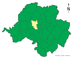
Altendorf (Altendorf)
Chemnitz-Altendorf is a district in the city of Chemnitz, located in the state of Saxony, Germany. While Altendorf itself might not be primarily recognized as a hiking destination, it’s located near several beautiful natural areas and trails that can offer great hiking experiences.
Nearby Hiking Opportunities:
-
Erzgebirge (Ore Mountains):
- Located just a short drive from Chemnitz, this mountain range offers a variety of trails suited for all skill levels. The area is known for its picturesque landscapes, dense forests, and charming villages.
- Popular trails include the Kammweg Erzgebirge (Ore Mountain Ridge Path), which provides stunning views and varied terrain.
-
Chemnitz City Parks:
- Within Chemnitz, there are several parks and green spaces where you can enjoy shorter hikes or walks, such as the Küchentreff Park and the Sachsenallee.
-
Zschopau Valley:
- The Zschopau River offers scenic trails along its banks, providing both gentle walks and more challenging hikes depending on the chosen path.
-
Lichtenwalde Baroque Garden:
- While primarily a garden, the surrounding areas offer trails for a pleasant hike amid well-maintained landscapes.
Tips for Hiking in the Area:
- Trail Maps: Always carry a good map or a GPS device with trail information, as some paths can be less clearly marked.
- Weather Preparedness: The weather in Saxony can change quickly, so wear appropriate clothing, layer up, and bring rain gear if needed.
- Hydration and Snacks: Ensure you have enough water and snacks, particularly for longer hikes.
- Local Regulations: Be aware of any local rules regarding trail use, particularly in protected areas.
Conclusion:
While Chemnitz-Altendorf might not be a major hiking hub on its own, its proximity to the Ore Mountains and other natural sites provides ample opportunities for outdoor enthusiasts. Whether you're looking for a leisurely stroll or a challenging hike, the surrounding region has plenty to offer. Happy hiking!
- Страна:

- Координаты: 50° 50' 12" N, 12° 53' 5" E


- GPS треки (wikiloc): [Ссылка]
- Площадь: 4.41 кв.км
- Хранилище Wikidata: Wikidata: Q1069494
- Катеория в википедии: [Ссылка]
- код VIAF: Альт: [247864726]
- ID отношения в OpenStreetMap: [414879]
- идентификатор местоположения ArchINFORM: [43537]

