Киуро (Chiuro, Chiuro)
.svg)
- коммуна Италии
 Hiking in Киуро
Chiuro, located in the Valtellina region of northern Italy, is surrounded by stunning landscapes that make it a great destination for hiking enthusiasts. Here’s what you can expect when hiking in and around Chiuro:
Scenic Trails
-
Valtellina Trail: This long-distance trail runs through the entire Valtellina valley, offering various stages and routes that you can explore. Enjoy scenic views of vineyards, mountains, and charming villages.
-
Monte Falso: A popular hike that offers a panoramic view of the surrounding valleys and peaks. The trail is suitable for various skill levels and provides a chance to experience local flora and fauna.
-
Val di Mello: Although a bit further from Chiuro, this valley is highly recommended for its breathtaking beauty. The trails here lead you through stunning granite formations, crystal-clear waters, and lush forests.
Tips for Hiking in Chiuro
- Prepare for Weather: The weather can change rapidly in the mountains, so layering and checking forecasts before heading out is essential.
- Stay Hydrated: Carry enough water, especially during summer months when temperatures can rise.
- Navigation: Make sure to carry a map or GPS device, as some trails might not be well-marked.
- Safety Gear: Wear sturdy hiking boots and consider bringing trekking poles for stability on uneven terrain.
Local Highlights
- Gastronomy: After a day of hiking, indulge in local dishes such as pizzoccheri (a type of pasta) and regional wines, which are also a highlight of the Valtellina area.
- Cultural Sites: Chiuro itself is rich in history, with beautiful architecture and churches. You can explore the village and enjoy its cultural offerings.
Best Time to Visit
- Spring and Fall: These seasons offer mild temperatures and stunning natural colors. Early summer can also be excellent, but it’s essential to check trail conditions as snow may linger in higher areas.
Hiking in Chiuro provides a blend of natural beauty and cultural experiences, making it a rewarding destination for all levels of hikers. Enjoy your adventure!
- Страна:

- Почтовый код: 23030
- Телефонный код: 0342
- Код автомобильного номера: SO
- Координаты: 46° 10' 0" N, 9° 59' 0" E


- GPS треки (wikiloc): [Ссылка]
- Высота над уровнем моря: 390 м m
- Площадь: 51.76 кв.км
- Население: 2552
- Веб сайт: http://www.comune.chiuro.so.it
- Википедия русская: wiki(ru)
- Википедия английская: wiki(en)
- Википедия национальная: wiki(it)
- Хранилище Wikidata: Wikidata: Q39914
- Галерея изображений в википедии: [Ссылка]
- Катеория в википедии: [Ссылка]
- код Freebase: [/m/0gj2wg]
- код GeoNames: Альт: [6536125]
- код VIAF: Альт: [238775693]
- ID отношения в OpenStreetMap: [46960]
- WOEID: [714029]
- UN/LOCODE: [ITCHU]
- код ISTAT: 014020
- кадастровый код Италии: C651
Граничит с регионами:


Монтанья-ин-Вальтеллина
- коммуна Италии
Hiking in Монтанья-ин-Вальтеллина
Montagna in Valtellina, located in the Sondrio province of Lombardy, Italy, is an excellent destination for hiking enthusiasts. This area is part of the Valtellina Valley, which is known for its stunning landscapes, charming villages, and rich cultural heritage....
- Страна:
- Почтовый код: 23020
- Телефонный код: 0342
- Код автомобильного номера: SO
- Координаты: 46° 11' 0" N, 9° 54' 0" E
- GPS треки (wikiloc): [Ссылка]
- Высота над уровнем моря: 567 м m
- Площадь: 44.97 кв.км
- Население: 3041
- Веб сайт: [Ссылка]


Кастелло-делл'Аккуа
- коммуна Италии
Hiking in Кастелло-делл'Аккуа
Castello dell'Acqua, located in the province of Sondrio in Lombardy, Italy, offers stunning hiking opportunities with breathtaking views of the surrounding Alps. Nestled in the heart of the Valtellina valley, it’s a great spot for those seeking both scenic beauty and outdoor adventure....
- Страна:
- Почтовый код: 23030
- Телефонный код: 0342
- Код автомобильного номера: SO
- Координаты: 46° 9' 0" N, 10° 1' 0" E
- GPS треки (wikiloc): [Ссылка]
- Высота над уровнем моря: 664 м m
- Площадь: 14.07 кв.км
- Население: 629
- Веб сайт: [Ссылка]
Понте-ин-Вальтеллина
- коммуна Италии
Hiking in Понте-ин-Вальтеллина
Ponte in Valtellina is a picturesque town located in the Valtellina Valley in northern Italy, known for its stunning alpine scenery and a variety of outdoor activities, including hiking. Here are some key points about hiking in and around Ponte in Valtellina:...
- Страна:
- Почтовый код: 23026
- Телефонный код: 0342
- Код автомобильного номера: SO
- Координаты: 46° 11' 0" N, 9° 59' 0" E
- GPS треки (wikiloc): [Ссылка]
- Высота над уровнем моря: 500 м m
- Площадь: 67.73 кв.км
- Население: 2294
- Веб сайт: [Ссылка]
Ланцада
- коммуна Италии
Hiking in Ланцада
Lanzada, located on the beautiful Galician coast in Spain, is known for its stunning beaches, picturesque landscapes, and vibrant natural surroundings, making it a great destination for hiking enthusiasts. Here’s an overview of what to expect when hiking in the Lanzada area:...
- Страна:
- Почтовый код: 23020
- Телефонный код: 0342
- Код автомобильного номера: SO
- Координаты: 46° 16' 0" N, 9° 52' 0" E
- GPS треки (wikiloc): [Ссылка]
- Высота над уровнем моря: 1000 м m
- Площадь: 117.17 кв.км
- Население: 1335
- Веб сайт: [Ссылка]


Тельо
- коммуна Италии
Hiking in Тельо
Teglio, a charming town located in the Valtellina valley of northern Italy, is surrounded by stunning alpine landscapes, making it a fantastic destination for hiking enthusiasts. The area is known for its rich natural beauty, with a diverse range of trails suitable for various skill levels, from leisurely strolls to challenging hikes....
- Страна:
- Почтовый код: 23036
- Телефонный код: 0342
- Код автомобильного номера: SO
- Координаты: 46° 10' 0" N, 10° 4' 0" E
- GPS треки (wikiloc): [Ссылка]
- Высота над уровнем моря: 851 м m
- Площадь: 115.32 кв.км
- Население: 4534
- Веб сайт: [Ссылка]


Брусио
Hiking in Брусио
Brusio, located in the Graubünden region of Switzerland, offers stunning landscapes and a variety of hiking trails suitable for different skill levels. Here are some highlights and tips for hiking in and around Brusio:...
- Страна:

- Почтовый код: 7743; 7748; 7747; 7744
- Телефонный код: 081
- Код автомобильного номера: GR
- Координаты: 46° 15' 20" N, 10° 7' 8" E
- GPS треки (wikiloc): [Ссылка]
- Высота над уровнем моря: 1042 м m
- Площадь: 46.29 кв.км
- Население: 1135
- Веб сайт: [Ссылка]
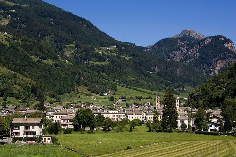
Поскьяво
Hiking in Поскьяво
Poschiavo is a picturesque valley located in the eastern part of Switzerland, with stunning landscapes that make it an excellent destination for hiking enthusiasts. The valley is part of the canton of Graubünden and is known for its blend of Swiss and Italian cultures, reflected in its charming villages and local cuisine....
- Страна:
- Почтовый код: 7742; 7746; 7741; 7710; 7745
- Телефонный код: 081
- Код автомобильного номера: GR
- Координаты: 46° 20' 0" N, 10° 2' 59" E
- GPS треки (wikiloc): [Ссылка]
- Высота над уровнем моря: 1014 м m
- Площадь: 191.01 кв.км
- Население: 3516
- Веб сайт: [Ссылка]